Körle
Körle is a community in the Schwalm-Eder district in Hesse, Germany. It lies about 20 km south of Kassel near the turn-off for Guxhagen on Autobahn A 7.
Körle | |
|---|---|
 Coat of arms | |
Location of Körle within Schwalm-Eder-Kreis district 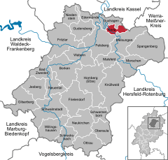  | |
 Körle  Körle | |
| Coordinates: 51°10′N 09°31′E | |
| Country | Germany |
| State | Hesse |
| Admin. region | Kassel |
| District | Schwalm-Eder-Kreis |
| Government | |
| • Mayor | Mario Gerhold (SPD) |
| Area | |
| • Total | 17.51 km2 (6.76 sq mi) |
| Elevation | 188 m (617 ft) |
| Population (2018-12-31)[1] | |
| • Total | 2,959 |
| • Density | 170/km2 (440/sq mi) |
| Time zone | CET/CEST (UTC+1/+2) |
| Postal codes | 34327 |
| Dialling codes | 05665 |
| Vehicle registration | HR |
| Website | www.koerle.de |
History
Körle was first mentioned in 1074 in a donation document from the Fulda monastery.
The community, as it is now, came into being as part of Hesse's municipal reforms, when the communities of Empfershausen, Lobenhausen and Wagenfurth were amalgamated with Körle on 1 February 1971.
Partnership
The community of Körle has maintained since 1991 a partnership with Floh-Seligenthal in Thuringia.
References
- "Bevölkerungsstand am 31.12.2018". Hessisches Statistisches Landesamt (in German). July 2019.
External links
Towns and municipalities in the district of Schwalm-Eder | ||
|---|---|---|
Schwalm-Eder district's coat of arms | ||
| Authority control |
|
|---|
This article is issued from Wikipedia. The text is licensed under Creative Commons - Attribution - Sharealike. Additional terms may apply for the media files.