Joondalup
Joondalup (/ˈdʒuːndəlʌp/) is a northern suburb of Perth, Western Australia, approximately 26 kilometres (16 mi) north of Perth's central business district. It acts as the primary urban centre in Perth's northern suburbs.
| Joondalup Western Australia | |
|---|---|
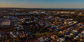 Arial view of Joondalup | |
 Joondalup | |
| Coordinates | 31°44′42″S 115°45′58″E |
| Population | 49,675 (2006 census)[1] |
| • Density | 1,267.2/km2 (3,282/sq mi) |
| Established | 1980s |
| Postcode(s) | 6027 |
| Area | 39.2 km2 (15.1 sq mi) |
| Location | 26 km (16 mi) from Perth |
| LGA(s) | City of Joondalup |
| State electorate(s) | Joondalup |
| Federal Division(s) | Moore |
History
During the latter part of the 1960s, the Metropolitan Regional Planning Authority developed the Corridor Plan for Perth which was published and adopted in 1970.[2] The plan called for the creation of five "sub-regional" retail centres (Fremantle, Joondalup, Midland, Armadale and Rockingham) which would form the commercial and economic focus of each "node", and take the retail burden away from the CBD.[3] The Corridor Plan was not endorsed by Parliament until 1973.[4][5]
In order to grow both the five "sub-regional" retail centres and these off-corridor regional shopping centres, a Retail Shopping Policy was developed by MRPA in 1976, and a Perth Metropolitan Region Retail Structure Plan was put in place to regulate the industry. This Plan was amended as new centres were required.[4] A review of the Corridor Plan in 1987 found that the sub-regional centres had failed to adequately compete against the regional shopping centres in the middle-distance suburbs.[4]
Most of the land in the area remained largely undeveloped until the 1960s, and Joondalup started to become the "city of the north" towards the late 1980s to the early 1990s when houses and businesses were established in the area. Joondalup is the key regional hub for the north of Perth, a status confirmed by the Western Australian State Government's new Directions 2031 strategy which names Joondalup town centre as one of two Primary Centres for the Perth metropolitan area.
The city is named after Lake Joondalup. The name Joondalup is a Noongar word, first recorded in 1837 and possibly meaning either "place of whiteness or glistening", or "place of a creature that can only move backwards".[6]
Geography
Joondalup as a centre has no statutory boundaries. The Australian Bureau of Statistics has determined a statistical area that covers all of the City of Joondalup north of Ocean Reef Road, which uses Lakeside Joondalup as a regional shopping centre and uses Joondalup railway station as a public transport hub. This area is bounded by the Indian Ocean to the west, Lake Joondalup to the east and the city boundary to the north, and encompasses the following suburbs
|
Demographics
Religion
Joondalup has a large Christian majority, comprising 49% of the city's religious following, with the two largest denominations being Anglican (12,208 or 24.6%) and Catholic (12,154, 24.1%). 21.6% of Joondalup's population professed no religion.
Age structure
Joondalup contains a fairly youthful population, with a median age of 28, compared to the Australian national average of 37 in 2006.
Governance

Joondalup is governed by the City of Joondalup local government area, which covers the whole city area and extends southwards to the suburbs of Sorrento, Duncraig and Greenwood. Until 1998, the area was entirely governed by the neighbouring City of Wanneroo.
Culture
Retail
Joondalup's central business district, centred on Grand Boulevard, is largely a shopping and retail area lined with townhouses and apartments. Lakeside Joondalup Shopping City is located adjacent to the Joondalup railway station and backs onto Grand Boulevard.
Events and festivals
Joondalup is home to the Joondalup Festival, an annual event that takes place in the CBD featuring markets, music, fashion, street arts, fairground rides and street parades.[7] The festival is free-of-charge and attracts people from all over the Perth metropolitan area. Kaleidoscope Festival has also been held in the city since 2016, featuring various art and light installations. The festival attracted over 50,000 people in its inaugural year.[8]
Parks and beaches
The city has a number of parks including Central Park and Neil Hawkins Park in the Yellagonga Regional Park. The Neil Hawkins Park is home to many parrots, including the Australian ringneck, cockatoos and kangaroos. The park is located alongside Lake Joondalup and wetlands which stretches out between Burns Beach Road to the north and Ocean Reef Road to the south. These wetlands provide refuge for migratory birds.
Joondalup's coastal front consists of Burns Beach in the north and Beaumaris Beach in Ocean Reef, running onto the Ocean Reef Boat Harbour in the south.
Sports

Joondalup is home to ECU Joondalup SC, Joondalup United FC and Sorrento FC who play in the National Premier Leagues which is Australia's second tier association football league. Sorrento FC is one of Joondalup's most successful clubs and their derbies with ECU Joondalup are always eagerly anticipated.
Arena Joondalup, located northwest of Lakeside Shopping Centre, is the home venue of West Perth Football Club and Wanneroo Basketball Association. The Arena also hosts music events and festivals during the year, as well as the Home and Lifestyle Expo, an annual exhibition held in late March to early April.
Furthermore, in the early 1990s with the addition of the Western Reds to the National Rugby League, the Joondalup Giants was established playing home games from Admiral Park in WARL completion.
Nightlife
Joondalup is a popular city for nightlife on weekends and Friday nights, with most of its pubs and nightclubs located in close proximity to each other in the CBD. The city was granted the status of "tourism precinct" by the State Government in 2009, allowing extended retail trading hours.
Other
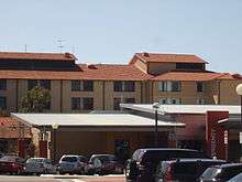
The council chambers for the City of Joondalup are located in Joondalup's central business district. The complex includes Joondalup Library, which serves as the central library and local history centre for both the City of Joondalup and the City of Wanneroo local authorities. The Joondalup Health Campus, the major public hospital for Perth's northern suburbs, a major police station and the Joondalup offices of the Australian Electoral Commission are also located in the CBD.
Education
Joondalup contains the following significant tertiary institutions or campuses in its central business district:
- North Metropolitan TAFE
- Edith Cowan College
- Edith Cowan University
- West Australian Institute of Further Studies
- Australian Institute for University Studies (co-located with Curtin University of Technology)
- Western Australia Police Academy
The following secondary colleges are scattered around the Joondalup urban area and cover large catchment areas:
- Ocean Reef Senior High School (Years 8–12)
- Belridge Senior High School (Years 8–12)
- Kinross College (Years 6–10)
- Lake Joondalup Baptist College (Years K-12, private)
- Prendiville Catholic College (Years 7–12, private)
- Mater Dei College (Years 7–12, private)
Infrastructure
Health
Joondalup contains a major public hospital, Joondalup Health Campus, which serves as the main health facility for most of Perth's northern suburbs, as far north as Two Rocks. Joondalup Private Hospital is also incorporated into the public Health Campus, and both facilities are owned and operated by Ramsay Health Care.
Utilities
The Joondalup region's primary potable water supply comes from the nearby Gnangara Mound. The water is treated at the Wanneroo Groundwater Treatment Plant and, as in most of Western Australia, is managed by the Water Corporation.
Road transport
Joondalup is situated on the Mitchell Freeway and forms the northern terminus of the road. The freeway links Joondalup to Perth and further south and has the following exits in the city:
- Ocean Reef Road, Heathridge & Edgewater
- Hodges Drive, Connolly & Joondalup CBD
- Shenton Avenue, Currambine & Joondalup CBD
- Burns Beach Road, Currambine & Joondalup (suburb)
Two lesser arterial roads, Joondalup Drive and Marmion Avenue, run parallel to the freeway through the eastern and western suburbs respectively, with all three roads sharing the same major exits in the urban area. Joondalup Drive links Joondalup east to Wanneroo Road and the suburbs of the City of Wanneroo, while Marmion Avenue follows the course of the freeway south, to West Coast Highway and Perth's inner coastal suburbs.
Public transport
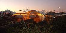
The city contains three railway stations on the Joondalup line, at Edgewater, Currambine and the Joondalup CBD, providing a direct rail link to the Perth CBD, as well as Butler in the north. The Joondalup interchange acts as a large public transport hub, providing bus links to all surrounding suburbs in the City of Joondalup LGA, as well as Banksia Grove in the City of Wanneroo.
Joondalup is one of three urban precincts in Perth to have free CAT bus services (the other two being Fremantle and the Perth CBD). CAT Routes 10 and 11 travel around Joondalup's central precinct, ferrying passengers to Lakeside Joondalup Shopping Centre, Joondalup Health Campus, Edith Cowan University, West Coast Institute of Training and various stops around the CBD.
References
- Australian Bureau of Statistics (25 October 2007). "Joondalup (C) – North (Statistical Local Area)". 2006 Census QuickStats. Retrieved 26 August 2011.
- Metropolitan Region Planning Authority (1970). The corridor plan for Perth. OCLC 521177.
- Stephenson, Gordon (1975). The Design of central Perth: Some Problems and Possible Solutions. A Study made for the Perth Central Area Design Co-ordinating Committee. UWA. p. 44. ISBN 0-85564-107-X.
chap. 7 item 3 Regional shopping centres have been established in several suburbs. ..., and generally take the form of a pedestrian precinct surrounded by large car parks. [see also 7.2 & 7.4.]
- Ministry for Planning. "Evolution of the Spatial Distribution of Commercial Development". Commercial Land Use Survey 1997. Archived from the original on 6 October 2007. Retrieved 17 July 2007.
- Gentilli, Joseph (1979). Western Landscapes. University of Western Australia. p. 459. ISBN 0-85564-155-X.
- Western Australian Land Information Authority. "History of metropolitan suburb names – J". Retrieved 17 January 2007..
- "Tens of thousands turn out for 2018 Joondalup Festival". Community News Group. 29 March 2018. Retrieved 29 January 2019.
- "Kaleidoscope attracts more than 50,000 to inaugural event". Community News Group. 17 November 2016. Retrieved 29 January 2019.
External links
| Wikimedia Commons has media related to Joondalup, Western Australia. |