John Kilpatrick Turnpike
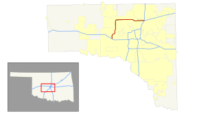
The John Kilpatrick Turnpike is a toll road in Oklahoma City, Oklahoma. The turnpike forms a partial loop that runs from State Highway 152 (SH-152) in the west to an interchange with Interstate 35 (I-35) and I-44 in the east. At the eastern terminus, traffic continuing east merges with I-44 traffic, forming the Turner Turnpike. The Kilpatrick Turnpike is 25.3 miles (40.7 km) long.
| |
|---|---|
 | |
| Route information | |
| Maintained by OTA | |
| Existed | September 1, 1991–present |
| Major junctions | |
| West end | |
| |
| East end | |
| Location | |
| Counties | Canadian, Oklahoma |
| Highway system | |
Oklahoma State Highway System
| |

Route description
The Kilpatrick Turnpike's entire route lies within the city limits of Oklahoma City. There are no exit numbers assigned to any of the turnpike's interchanges.[1]
The Kilpatrick Turnpike begins at an at-grade intersection with S.W. 15th Street just west of Sara Road in far western Oklahoma City. The turnpike heads north from this intersection to an interchange with I-40/US-270. Not all movements are possible at this interchange; I-40 is not accessible from the northbound Kilpatrick Turnpike, and the southbound turnpike is not accessible from I-40. Another partial interchange is located at N.W. 10th Street, with ramps allowing drivers to join the northbound turnpike and exit the southbound turnpike. The turnpike continues north, passing just east of the Yukon city limits, before making an S-curve to the east, running west of Lake Overholser. The turnpike's first full interchange is with State Highway 66 (SH-66), which runs along N.W. 39th Expressway. North of this interchange, the Kilpatrick Turnpike crosses the North Canadian River. The next interchange is with Wilshire Boulevard. Immediately north of Wilshire Boulevard is the first barrier toll plaza. The highway's next interchange is with SH-3, also known as the Northwest Expressway. The turnpike curves to the east north of here, entering Oklahoma County.[1]
East of the county line, the Kilpatrick Turnpike follows the route of Memorial Road; Memorial splits into a pair of one-way frontage roads during this stretch. The next interchange, at Council Road, allows eastbound traffic to exit and westbound to enter the turnpike. The two interchanges to the east of here, at Rockwell Avenue and MacArthur Road, allow full access. At Meridian Avenue, traffic can exit the turnpike westbound and enter it eastbound. To the east lies an interchange with SH-74. This is the northern terminus of the Lake Hefner Parkway freeway; north of here, SH-74 follows Portland Avenue.[1] The interchange only allows direct access from the westbound Kilpatrick Turnpike to southbound SH-74 and from northbound SH-74 to the eastbound turnpike; all other movements must be completed via Memorial Road.[2] The turnpike continues east, with full interchanges at May and Pennsylvania (Penn) avenues. East of Penn, the highway curves southeast, leaving the Memorial Road corridor. The next interchange is at Western Avenue. To the east of here is the second barrier toll plaza. After the toll plaza is the interchange with US-77, a freeway also known as the Broadway Extension. The turnpike then has an interchange at Eastern Avenue. The turnpike then comes to an end at I-35/I-44. Eastbound I-44 splits away from northbound I-35 at this interchange to form the Turner Turnpike, and the eastbound Kilpatrick Turnpike mainline merges into the Turner Turnpike toward Tulsa.[1]
Law enforcement along the John Kilpatrick Turnpike is provided by Oklahoma Highway Patrol Troop YE, a special troop assigned to the turnpike.[3]
History
In 1987, the Oklahoma Legislature authorized construction of the first phase of the turnpike, between I-35 and Lake Hefner Parkway. It was completed in 1991. In 2001, an extension of the turnpike to I-40 was completed.[4]
Future
On October 29, 2015, Governor Mary Fallin announced that the Kilpatrick Turnpike would be extended south to end at SH-152 near Will Rogers World Airport as part of Driving Forward, a $892 million turnpike package. The project began on January 20, 2018.[5]
The extension was opened January 9, 2020.[6]
Tolls
It costs $1.30 x 2 to drive the entire turnpike; customers using the Pikepass electronic toll system receive a slight discount.
Exit list
All exits are unnumbered.
| County | Location | mi[2] | km | Destinations | Notes |
|---|---|---|---|---|---|
| Oklahoma | Oklahoma City | 0.00 | 0.00 | Council Road | Westbound entrance only |
| Counterclockwise terminus,[7] freeway continues east as SH-152 (Airport Road) | |||||
| Canadian | Morgan Road | ||||
| Mustang | SW 29th Street | Northbound exit and Southbound entrance | |||
| Yukon | Sara Road | Northbound entrance and Southbound exit | |||
| SW 15th Street | Southbound exit and northbound entrance[7] | ||||
| 0.8 | 1.3 | I-40 exits 138B-139[7] | |||
| 2.0 | 3.2 | NW 10th Street | Southbound exit and northbound entrance | ||
| 4.8 | 7.7 | ||||
| 7.4 | 11.9 | Wilshire Boulevard | |||
| 9.4 | 15.1 | ||||
| Oklahoma | Oklahoma City | 12.7 | 20.4 | Council Road | Eastbound exit and westbound entrance |
| 13.7 | 22.0 | Rockwell Avenue | |||
| 14.7 | 23.7 | MacArthur Boulevard | |||
| 15.7 | 25.3 | Meridian Avenue | Westbound exit and eastbound entrance | ||
| 16.7 | 26.9 | Signed as one single exit eastbound | |||
| 17.7 | 28.5 | May Avenue | |||
| 18.7 | 30.1 | Penn Avenue | Full name "Pennsylvania" | ||
| 19.7 | 31.7 | Western Avenue | |||
| 21.4 | 34.4 | No direct access from US-77 south to the turnpike east | |||
| 22.9 | 36.9 | Eastern Avenue | |||
| Edmond | 25.2 | 40.6 | Eastbound exit and westbound entrance | ||
| 25.3 | 40.7 | Left exit eastbound; no westbound exit | |||
| 25.6 | 41.2 | Turner Tpk. (I-44 east) continues beyond clockwise terminus | |||
1.000 mi = 1.609 km; 1.000 km = 0.621 mi
| |||||
See also
References
- Official State Map (PDF) (Map) (2013–14 ed.). Oklahoma Department of Transportation. Oklahoma City inset. Retrieved November 30, 2013.
- Google Maps
- "Oklahoma Highway Patrol". Retrieved 2008-04-05.
- https://www.pikepass.com/about/History.aspx
- "Driving Forward OK". Oklahoma Turnpike Authority. Retrieved 2015-11-19.
- https://www.drivingforwardok.com/sw-kilpatrick-extension
- "Southwest JKT Extension" (PDF). Driving Forward OK. Oklahoma Turnpike Authority. Retrieved April 13, 2018.