Jatikramat River
Jatikramat River (Kali Jatikramat or Kali Jati Kramat) is a river in the Bekasi, West Java and eastern part of the Special Capital Region of Jakarta, Indonesia.[1] The lower portions of the original river have been channelized and directed into the eastern flood canal, "Banjir Kanal Timur", which continues to flow to the Java Sea in the district of Marunda, Cilincing, North Jakarta.[2] The river regularly causes flooding in the city of Bekasi[3] and Jakarta.[4]
| Jatikramat River Kali Djatikramat, Kali Jati Kramat | |
|---|---|
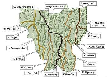 Jatikramat River ("K. Jati Kramat"), middle right in the map of rivers and canals of Jakarta (2012) | |
| Native name | Kali Jatikramat |
| Location | |
| Country | Indonesia |
| State | Jakarta |
| Physical characteristics | |
| Source | |
| ⁃ location | Bekasi, West Java |
| Mouth | Banjir Kanal Timur |
| Length | 14.5 km (9.0 mi) |
History
Jatikramat and the other two nearby rivers: Cakung dan Buaran, flow from Bekasi and interconnect until draining into the Jakarta Bay in the district of Marunda through Cakung Drain and currently through Banjir Kanal Timur. In the past, the three rivers supplied water for drinking and agriculture in the area.[5] Due to continuous erosion and accumulation of trash, the average width of Jatikramat was reduced from the original 10 meter to only 3 meter in 1990.[6]
The river often causes flooding to the surrounding area. A research by Pieter J Kunu and H Lelolterry of the Pattimura University, Ambon, showed that the development of the city changed 85% land of Jakarta to be waterproof, unable to absorb surface water and resulted in regular floods. One of the solutions was by constructing a flood-control canal, Banjir Kanal Timur.[5] The flow of Cakung, Buaran, Jati Kramat, Sunter, and Cipinang rivers was cut to drain into the canal, and thereby reducing the occurrence of flood.[5] However, one little part of Jatikramat river is now still connected to Buaran River at a length of almost 50 meter.[7]
Hydrology
The watershed of Jatikramat in the city of Bekasi comprises the flow of Cileungsi, Cikeas and Bekasi rivers.[3]
Jatikramat river has a length of 14.50 kilometres (9.01 mi), with the watershed area (Indonesian: Daerah Pengaliran Sungai) of 16.50 km².[8] The average daily rainfall is 154 mm, with the peak debit at 45 m³.[8]
Geography
The river flows in the northwest area of Java with predominantly tropical rainforest climate (designated as Af in the Köppen-Geiger climate classification).[9] The annual average temperature in the area is 28 °C. The warmest month is September, when the average temperature is around 31 °C, and the coldest is May, at 26 °C.[10] The average annual rainfall is 3674 mm. The wettest month is December, with an average of 456 mm rainfall, and the driest is September, with 87 mm rainfall.[11]
Normalisation
In early 2000, the flow of Jati Kramat was straightened; the river was dredged and the banks were strengthened with concrete, to yield a width of 5 meter with the depth of more than 3 meter.[6] The normalisation in Pondok Kelapa, Duren Sawit, East Jakarta, was performed since 2015.[12] This normalisation resulted a width of around 10 meter, to control annual flooding. The project was to be completed until the river mouth at Kanal Banjir Timur (KBT).[13]
References
- Kali Jatikramat - Geonames.org.
- (in Indonesian) Wujudkan Wisata Sungai, Kemenpar Dukung Sport Tourism BKT 5K - Nofie Tessar, Liputan6, 13 Sep 2017.
- Walikota Bekasi Bakal Relokasi Warga Bantaran Kali Jatikramat - PosKota News - 8 Desember 2015
- Kali Buaran Meluap, Permukiman di Taman Malaka Selatan Tergenang, Robertus Belarminus, Kompas.com - 21 Feb 2017.
- Tiga Sungai Menghidupkan Timur Jakarta, Kompas.com - 28 Mei 2016.
- (in Indonesian) Kesadaran Menjaga Sungai yang Semakin Runtuh. Kompas.com - 08 Jun 2016.
- (in Indonesian) Kanal Timur yang Mengubah Alur Sungai. Kompas.com - 24 Mei 2016.
- (in Indonesian) BBWS Ciliwung Cisadane. Pengendalian Banjir dan Perbaikan Sungai Ciliwung Cisadane (PBPS CC). https://konservasidasciliwung.wordpress.com/kebijakan-tentang-ciliwung/bbws-ciliwung-cisadane/ Archived in Konservasi DAS Ciliwung] - April 2012.
- Peel, M C; Finlayson, B L; McMahon, T A (2007). "Updated world map of the Köppen-Geiger climate classification". Hydrology and Earth System Sciences. 11. doi:10.5194/hess-11-1633-2007.
- "NASA Earth Observations Data Set Index". NASA. 30 January 2016.
- "NASA Earth Observations: Rainfall (1 month - TRMM)". NASA/Tropical Rainfall Monitoring Mission. 30 January 2016.
- Normalisasi Kali Rutin, Rawan Banjir Berkurang. PosKota News. 22 November 2015
- (in Indonesian) Sudin Tata Air Jaktim Bakal Normalisasi Kali Jati Kramat - Tribun News- Warta Kota, 14 Jun 2015.