Jarvisfield, Queensland
Jarvisfield is a coastal locality in the Shire of Burdekin, Queensland, Australia.[1]
| Jarvisfield Queensland | |||||||||||||||
|---|---|---|---|---|---|---|---|---|---|---|---|---|---|---|---|
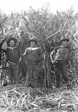 The Olsen brothers, Sugarcane farmers in Jarvisfield, circa 1920 | |||||||||||||||
 Jarvisfield | |||||||||||||||
| Coordinates | 19.5753°S 147.4911°E | ||||||||||||||
| Postcode(s) | 4807 | ||||||||||||||
| Area | 111.1 km2 (42.9 sq mi) | ||||||||||||||
| LGA(s) | Shire of Burdekin | ||||||||||||||
| State electorate(s) | Burdekin | ||||||||||||||
| Federal Division(s) | Dawson | ||||||||||||||
| |||||||||||||||
Geography
Jarvisfield is bounded by the Coral Sea to the east, the Burdekin River to the south and Plantation Creek to the north.[2]
The locality is flat low-lying land (below 10 metres above sea level). Most of the locality is freehold and used for growing sugarcane. However, the most eastern coastal parts of the locality are not developed and are at risk of coastal erosion from storms and from sea levels rising.[2][3]
A cane tramway through the locality carries harvested sugarcane to the local sugar mills, Pioneer Sugar Mill and Kalamia Sugar Mill, both located in Brandon.[2]
History
The Budekin River was explored by John Clements Wickham in HMS Beagle in 1839. In 1859 the lower Burdekin River was explored by Captain Sinclair and James Gordon from Bowen. After the Separation of Queensland in December 1859, the newly established Queensland Parliament sent further expeditions to assess the potential of the Burdekin River for settlement, leading to the area being officially opened for settlement from 1 January 1861, leading to the "Great Land Grab".[4] One of the larger properties established was Jarvisfield Station owned by Robert Towns and Alexander Stewart, both of Sydney. The present day locality takes its name from the Jarvisfield Station (although it is not as large in area as that pastoral run).[5]
In 1863–1864 there was an attempt to establish a port called Wickham on the north bank of the Burdekin River near the Jarvisfield Estate, despite Captain Wickham himself being dubious as to its viability noting that the river had two entrances, both very shallow, and that the river banks were vulnerable to flooding. However, the project proceeded but ultimately failed due to constant problems with mosquitoes, difficulties in navigating to upper reaches of the Burdekin through much of the year and problems with coastal erosion from storms.[6]
Initially Jarvisfield Station was used for cattle grazing. In 1869, Alexander Stuart attempted to grow sugar as did a number of other local farmers but inconsistent rainfall was a problem, so cattle grazing was the most common use of the land in the area. It was only when it was realised that the freshwater lagoons in the Burdekin Delta could be used for irrigation that the reliable cultivation of sugarcane became possible and far more profitable than cattle grazing. It was possible for a farmer to make a good living from a small block of land with sugarcane compared with a large parcel of land needed to make a good living from cattle. This raised the value of land and larger estates, such as Jarvisfield Station, were subdivided. This brought more farmers into the area and with them the extra labour needed to grown sugarcane. This increase in population led to the development of towns and service industries in the Burdekin district.[7]
Jarvisfield State School opened on 29 March 1915.[8] It celebrated its centenary on 3 October 2015.[9]
Education
Jarvisfield State School is a primary (P-6) school for boys and girls operated by the Queensland Government on the corner of Rita Island Road and Loram Road. In 2016, the school had an enrolment of 13 students with 2 teachers (1 full-time equivalent) and 5 non-teaching staff (2 full-time equivalent).[10] The school opened on 29 March 1915.[11]
References
- "Jarvisfield - locality in Shire of Burdekin (entry 42291)". Queensland Place Names. Queensland Government. Retrieved 28 September 2017.
- "Queensland Globe". State of Queensland. Retrieved 9 October 2017.
- "Coastal Hazard Areas" (PDF). Queensland Government. 2015.
- "LAND ORDERS TO NEW COMERS". The Moreton Bay Courier. XV (955). Queensland, Australia. 11 December 1860. p. 2. Retrieved 12 October 2017 – via National Library of Australia.
- "History of the Burdekin". Burdekin Shire Council. Archived from the original on 12 October 2017. Retrieved 12 October 2017.
- Bell, Peter (2000), A short history of Thuringowa (PDF), Thuringowa City Council, p. 34, ISBN 978-0-9577305-3-3, archived (PDF) from the original on 12 October 2017, retrieved 12 October 2017
- Bell, Peter (2000), A short history of Thuringowa (PDF), Thuringowa City Council, p. 37, ISBN 978-0-9577305-3-3, archived (PDF) from the original on 12 October 2017, retrieved 12 October 2017
- Queensland Family History Society (2010), Queensland schools past and present (Version 1.01 ed.), Queensland Family History Society, ISBN 978-1-921171-26-0
- "Jarvisfield State School 100 Years Centenary Celebration". Burdekin Shire Council. 27 August 2015. Archived from the original on 12 October 2017. Retrieved 12 October 2017.
- "Annual Report 2016" (PDF). Jarvisfield State School. Archived (PDF) from the original on 11 October 2017. Retrieved 11 October 2017.
- "Opening and closing dates of Queensland Schools". Queensland Government. Retrieved 18 April 2019.
Further reading
- Hall, W. H; Jarvisfield State School (1965), Jarvisfield School golden jubilee 1915–1965, Jarvisfield School Jubilee Committee], retrieved 11 October 2017
External links
![]()
- "Jarvisfield". Queensland Places. Centre for the Government of Queensland, University of Queensland.