Jab'a
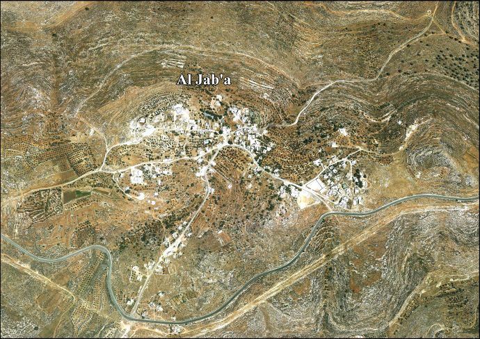
Jab'a (Arabic: الجبعة) is a Palestinian village in the central West Bank, located 17 kilometers north of Hebron and 15 kilometers southwest of Bethlehem. Located three kilometers east of the Green Line, it is located in the Seam Zone, surrounded by the Israeli settlements in the Gush Etzion Regional Council and the Israeli West Bank barrier. Nearby Palestinian towns and villages include Surif adjacent to the Jaba'a, Wadi Fukin and Nahalin to the north. It is the northernmost locality in the Hebron Governorate. According to the Palestinian Central Bureau of Statistics, Jab'a had a population of approximately 896 in 2007.[2] Jab'a has a total land area of 10,099 dunams, of which 1,002 dunams as built-up area.[3]
al-Jab'a | |
|---|---|
Local Development Committee | |
| Arabic transcription(s) | |
| • Arabic | الجبعة |
| • Latin | Jaba'a (official) Jab'aa (unofficial) |
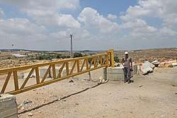 Road block between Jab'a and neighbouring Surif | |
 al-Jab'a Location of al-Jab'a within Palestine | |
| Coordinates: 31°40′29″N 35°04′40″E | |
| Palestine grid | 157/120 |
| State | State of Palestine |
| Governorate | Bethlehem |
| Government | |
| • Type | Local Development Committee |
| • Head of Municipality | No'man Hamdan |
| Area | |
| • Total | 10,099 dunams (10.1 km2 or 3.9 sq mi) |
| Population (2007) | |
| • Total | 896 |
| • Density | 89/km2 (230/sq mi) |
| Name meaning | "Hill"[1] |
History
Jab'a dates back to the Canaanites. The village is mentioned in Eusebius' renowned work, Onomasticon, as Gabatha [Gava'ot] (Γαβαθα),[4] believed by historical geographer, Samuel Klein, to be Jab'a southeast of Bayt Nattif. Jab'a has been identified by Conder as the biblical site of Gibeah,[5] mentioned in Joshua 15:57. Although not conclusive, it is said to be the burial-site of Habakuk the prophet. Elsewhere Eusebius purports that Habakuk was buried near a place called Ενκηλα (`Ain Qe'ilah), seven miles from Bayt Jibrin, and which place is now called Khirbet Qila.[6] Byzantine ceramics have been found here.[7]
Ottoman era
In 1596, Jaba appeared in Ottoman tax registers as being in the Nahiya of Quds of the Liwa of Quds, with a population of 3 Muslim households. The villagers paid a fixed tax-rate of 33.3% on wheat, barley, olives, and goats or beehives; a total of 1,110 akçe.[8]
In 1863, the French explorer Victor Guérin found Jab'a reduced to a hundred souls,[9] while the Palestine Exploration Fund's Survey of Western Palestine described Jeba in 1883 as "a small village standing upon a high, narrow ridge, with a steep valley to the north. The houses are of stone. To the east are caves in the face of the rock."[10]
British Mandate of Palestine era
In the 1922 census of Palestine conducted by the British Mandate authorities, Al Jaba'a had a population of 122 inhabitants, all Muslims.[11] while at the time of the 1931 census, El Jab'a had a population of 176, still Muslim, living in a total of 36 houses.[12]
In the 1945 statistics the population of El Jab'a was 210, all Muslims,[13] who owned 5,593 dunams of land according to an official land and population survey.[14] 102 dunams were plantations and irrigable land, 1,880 used for cereals,[15] while 12 dunams were built-up (urban) land.[16]
Jordanian era
In the wake of the 1948 Arab–Israeli War, and after the 1949 Armistice Agreements, Jab’a came under Jordanian rule.
1967 and aftermath
Since the Six-Day War in 1967, Jab'a has been under Israeli occupation.
After the 1995 accords, 3.5% of village land was classified as Area B land, the remaining 96.5 % as Area C. The Israeli West Bank barrier extends on Al Jab’a lands. It is effectively inside the Gush Etzion bloc, isolating Jab'a' from neighboring Palestinian villages and 90% of its land.[18]
On 25 February 2015, in an apparent price tag attack, a mosque in the village was torched. Israeli police were investigating it. The attack coincided with the anniversary of the Cave of the Patriarchs massacre that took place in Hebron 21 years ago.[19] The fire was discovered by worshipers who quickly extinguished it. The carpets and walls were damaged but no one was reported to have been injured. Graffiti in Hebrew called for "revenge attacks" against Arabs and Muslims, according to eyewitnesses.[20]
The village houses are small and consist of just one spacious room surrounded by a large area of farmland, on which almonds and olives grapes and are cultivated.[21]
References
- Palmer, 1881, p. 296
- 2007 PCBS Census Archived 2010-12-10 at the Wayback Machine Palestinian Central Bureau of Statistics. p.118.
- Al Jaba'a Border crossing under construction Poica, 26 December 2005.
- Eusebius, Onomasticon - The Place Names of Divine Scripture, (ed.) R. Steven Notley & Ze'ev Safrai, Brill: Leiden 2005, p. 70 (§339), note 339 ISBN 0-391-04217-3
- Tristram (1897), p. 69; Conder & Kitchener (1883), p. 53.
- Samuel Klein, Eretz Yehudah (the Land of Judah), Tel-Aviv 1939, p. 198.
- Dauphin, 1998, p. 921
- Hütteroth and Abdulfattah, 1977, p. 112
- Guérin, 1869, p. 382
- Conder and Kitchener, 1883, SWP III, p. 25
- Barron, 1923, Table V, Sub-district of Hebron, p. 10
- Mills, 1932, p. 32
- Government of Palestine, Department of Statistics, 1945, p. 23
- Government of Palestine, Department of Statistics. Village Statistics, April, 1945. Quoted in Hadawi, 1970, p. 50
- Government of Palestine, Department of Statistics. Village Statistics, April, 1945. Quoted in Hadawi, 1970, p. 93
- Government of Palestine, Department of Statistics. Village Statistics, April, 1945. Quoted in Hadawi, 1970, p. 143
- Government of Jordan, Department of Statistics, 1964, p. 22
- Al Jab’a Village, ARIJ, p. 16
- "Palestinian mosque torched in apparent 'price tag' attack". Al Jazeera America. 25 February 2015.
- "Mosque torched near Bethlehem in apparent hate crime". The Times of Israel. 25 February 2015.
- Jab'aa Centre for Cultural Heritage Preservation.
Bibliography
- Barron, J.B., ed. (1923). Palestine: Report and General Abstracts of the Census of 1922. Government of Palestine.
- Conder, C.R.; Kitchener, H.H. (1883). The Survey of Western Palestine: Memoirs of the Topography, Orography, Hydrography, and Archaeology. 3. London: Committee of the Palestine Exploration Fund.
- Dauphin, Claudine (1998). La Palestine byzantine, Peuplement et Populations. BAR International Series 726 (in French). III : Catalogue. Oxford: Archeopress. ISBN 0-860549-05-4.
- Government of Jordan, Department of Statistics (1964). First Census of Population and Housing. Volume I: Final Tables; General Characteristics of the Population (PDF).
- Government of Palestine, Department of Statistics (1945). Village Statistics, April, 1945.
- Guérin, V. (1869). Description Géographique Historique et Archéologique de la Palestine (in French). 1: Judee, pt. 3. Paris: L'Imprimerie Nationale.
- Hadawi, S. (1970). Village Statistics of 1945: A Classification of Land and Area ownership in Palestine. Palestine Liberation Organization Research Center.
- Hütteroth, Wolf-Dieter; Abdulfattah, Kamal (1977). Historical Geography of Palestine, Transjordan and Southern Syria in the Late 16th Century. Erlanger Geographische Arbeiten, Sonderband 5. Erlangen, Germany: Vorstand der Fränkischen Geographischen Gesellschaft. ISBN 3-920405-41-2.
- Mills, E., ed. (1932). Census of Palestine 1931. Population of Villages, Towns and Administrative Areas. Jerusalem: Government of Palestine.
- Palmer, E.H. (1881). The Survey of Western Palestine: Arabic and English Name Lists Collected During the Survey by Lieutenants Conder and Kitchener, R. E. Transliterated and Explained by E.H. Palmer. Committee of the Palestine Exploration Fund.
- Tristram, H.B. (1897). Bible Places: or, The Topography of the Holy Land: a Succinct Account of All the Places, Rivers, and Mountains, etc. London.
External links
- Welcome To al-Jab'a, Palestine Remembered
- Jaba, Welcome to Palestine
- Survey of Western Palestine, Map 17: IAA, Wikimedia commons
- Al Jab'a Village (Fact Sheet), Applied Research Institute–Jerusalem, ARIJ
- Al Jab’a Village, ARIJ
- Al Jab'a aerial photo, ARIJ
- The priorities and needs for development in Al Jab’a village based on the community and the local authorities’ assessment, ARIJ
- Al Jab’a
| Cities |  | |
|---|---|---|
| Municipalities | ||
| Villages |
| |
| Religion | ||
| Refugee camps | ||
| Other |
| |