Irvinebank Dam
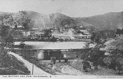
Irvinebank Dam was constructed initially around 1885 when a tin battery was built. The two creeks which form the basis of the dam at Irvinebank were known as Gibbs Creek and McDonald Creek, after the earliest prospectors. The battery was erected on the Gibbs Creek frontage, and the dam was constructed just below the junction of these two creeks and embraced an area, when full, of about 12 - 13 acres (53,000 m2) of water, with depths varying from about 15 feet (4.6 m) down to about 2 or 3 feet.[1]
| Irvinebank Dam | |
|---|---|
 | |
| Location | 34 km South West of Atherton, Queensland |
| Coordinates | 17.4291°S 145.2001°E |
| Type | reservoir |
| Basin countries | Australia |
References
- A History of Irvinebank. Atherton Tableland Netguide. Retrieved 12 February 2016.
Water supply in Queensland, Australia | |||||||||||||
|---|---|---|---|---|---|---|---|---|---|---|---|---|---|
| |||||||||||||
| |||||||||||||
This article is issued from Wikipedia. The text is licensed under Creative Commons - Attribution - Sharealike. Additional terms may apply for the media files.