Interstate 49 in Louisiana
Interstate 49 (I-49) is an Interstate Highway that spans 243.36 miles (391.65 km) in a north–south direction in the U.S. state of Louisiana.[1] It runs from I-10 in Lafayette to the Arkansas state line north of Shreveport, largely paralleling the older US 71 corridor, and connects the state's two east–west interstates at two of its metropolitan centers. Along the way, it serves the cities of Opelousas, Alexandria, and Natchitoches, intersecting several cross-state highways, such as US 190, US 167, US 165, US 84, and I-20.
| ||||
|---|---|---|---|---|
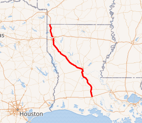
Opened sections of I-49 in Louisiana highlighted in red | ||||
| Route information | ||||
| Maintained by Louisiana DOTD | ||||
| Length | 247.219 mi[1] (397.860 km) 244.021 miles (392.714 km) opened[lower-alpha 1] | |||
| Existed | 1984–present | |||
| Major junctions | ||||
| South end | ||||
| ||||
| North end | ||||
| Location | ||||
| Parishes | Lafayette, St. Landry, Evangeline, Avoyelles, Rapides, Natchitoches, DeSoto, Caddo | |||
| Highway system | ||||
| ||||

I-49 was an intrastate Interstate Highway until December 12, 2012, when the designation was officially approved for an upgraded portion of US 71 in Missouri running from Joplin north to Kansas City.[3] Portions of the remaining roadway between Shreveport and Joplin are in various stages of planning or construction, as well as a southern extension of the route from Lafayette to New Orleans along the US 90 corridor.
Route description
I-49 begins its journey in Lafayette concurrent with U.S. Route 167 from I-10 to Opelousas at Exit 23. At Lafayette, motorists continuing southbound see the interstate highway change to U.S. 90 (Evangeline Thruway), a major thoroughfare taking travelers towards the heart of Lafayette. North of Lafayette, motorists on I-49 will parallel the ancient Mississippi river bed north of Carencro, and through Grand Coteau, just south of Opelousas.[4]
After leaving Opelousas, I-49 traverses the relatively flat, fertile farmlands until reaching Alexandria. From there, the highway roughly follows the Red River and Louisiana 1, bypassing the historic city of Natchitoches to the west on its way to Shreveport. At Shreveport, the highway parallels a railroad line just to the west until its terminus at I-20 southwest of downtown.[4]
On the north side of Shreveport, the route resumes at I-220 before having interchanges with LA 3194 and LA 1 before traveling northward through Caddo Parish, passing between the small communities of Gilliam and Hosston. I-49 crosses the Arkansas state line just north of Ida and proceeds toward the city of Texarkana.[5]
The heaviest traffic on I-49 occurs within the cities of Shreveport and Opelousas. The stretch of freeway in Shreveport sees an average of 70,000 vehicles per day, while the stretch of freeway between Lafayette and Carencro sees an average of 55,000 vehicles per day, and the stretch of freeway through Opelousas sees an average of 45,000 vehicles per day between the Judson Walsh Drive and Creswell Lane exits.
History
The original plans for Interstate Highways in Louisiana only included I-10 and I-20 with no connection in between. After I-55 was added in the 1950s, the state considered building a toll road to connect I-10 in southwestern Louisiana and I-20 in the northern part of the state, but later rejected the idea.
In the mid-1970s, the Federal Highway Administration approved an Interstate Highway to run between I-10 and I-20, beginning at I-10 in Lafayette and ending at I-20 in Shreveport. The mileage was gained from mileage released from other highways the states did not build as well as 153 miles (246 km) from a supplemental reserve.[6]
Construction of I-49 began in the early 1980s, with the first signed segment from I-10 to Washington, Louisiana, opening in 1984. After several delays, most of the highway was open by the early 1990s. The entire length of the 212-mile (341 km) road was completed May 1, 1996, when a 16.6-mile (26.7 km) section of highway in Alexandria named the Martin Luther King Jr. Highway was completed. The total cost of I-49's construction was about $1.38 billion.
Interstate 49 North is a 36-mile (58 km) construction project that will connect I-220 in Shreveport to the Arkansas state line, and has been divided into 11 segments. On November 27, 2013, the first 18.9-mile (30.4 km) section between Louisiana Highway 1 (LA 1) and US 71 opened to traffic;[7] the section to just south of the Arkansas state line opened in March 2014.[8] The segment from Shreveport to the Arkansas state line was opened in early 2015.[9] The portion between I-220 and LA 1, which includes an interchange with LA 3194, was estimated to be completed in early 2018. 4.25 miles (6.84 km) of this section, extending from LA 3194 to LA 1, was opened only to northbound traffic on May 31, 2017.[10] On June 15, 2018, the entire 5.25-mile (8.45 km) portion of I-49 between I-220 and LA 1, including an interchange with I-220, was opened to traffic, with the remaining interchange ramps expected to be completed in the late summer or early fall.[11] On October 17, 2018, the remaining interchange ramps were opened to traffic.[12]
Future
I-49 Geaux South
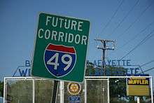
The Louisiana Department of Transportation and Development (La DOTD) is currently working to extend I-49 from its current terminus in Lafayette south and east to New Orleans along the existing US 90 corridor. The project is officially referred to as the "Interstate 49 Geaux South" program, or more commonly, "I-49 South".[13] This portion of US 90 is presently a divided four- and six-lane highway with several sections of freeway completed between Broussard and Raceland. In the New Orleans area, I-49 is planned to follow US 90 Bus. (the Westbank Expressway) through Westwego, Gretna, and across the Mississippi River via the Crescent City Connection to a terminus at I-10 in the New Orleans Central Business District. "Future I-49" signage is visible along this portion of the corridor, although as of 2015, construction has yet to begin. If this extension is completed I-49 will meet I-10 twice but there are many obstacles in the completion of the I-49 corridor in Louisiana. Cost has been an ongoing issue from the beginning, and this only increases yearly. In September 2015, however, La DOTD Secretary Sherri H. LeBas stated, "Completing I-49 South is a top priority for DOTD".[14]
In the Lafayette area, the project is divided into two projects, the "I-49 Connector" and the rest of the interstate from the Lafayette Regional Airport to LA 88. The I-49 Connector has a record of decision and is currently in the process of formulating the Environmental Impact Study.[14] It is projected to follow the existing path of the Evangeline Thruway, a divided six-lane surface roadway that passes just to the east of the downtown area. Much of the proposed 5.5 miles (8.9 km) will be elevated and is expected to cost between $750 and $850 million, making it the costliest portion of the entire 160-mile (260 km) route to be constructed. As of October 2015, engineer planning has not begun, nor has funding been secured for the project.[15] The remainder of the distance between the airport and LA 88 is planned to be a six-lane at-grade freeway with a 2-mile (3.2 km) segment of eight-lane elevated freeway through the neighboring city of Broussard. The planning is in cooperation with the Lafayette Metropolitan Planning Organization (MPO).[16]
In April 2015, La DOTD accepted proposals for an upcoming design-build project to construct an interchange at the junction of US 90 and LA 318, which is located in St. Mary Parish between Jeanerette and Baldwin. LA 318 travels southward from the St. Mary Sugar Co-Op on LA 182 at Sorrel and crosses US 90 at grade on the way to the Port of West St. Mary. The interchange is one of many projects along the projected I-49 corridor that is expected to improve traffic flow, safety, and hurricane evacuation.[17] On April 27, 2018, LaDOTD celebrated the opening of the junction of US 90 and LA 318 with a ribbon cutting ceremony.[18]
Shreveport area
La DOTD is also in the process of closing the last gap in the "I-49 North" project between I-20 and I-220 in Shreveport. A direct connection through Shreveport, known as the Inner City Connector, is controversial since its path is projected to pass through the residential Allendale neighborhood, which would necessitate the displacement of many of its residents. A no-build alternative would route through traffic via the existing LA 3132 (Inner Loop Expressway) and I-220 alignments after necessary improvements to those highways are carried out.[19][20][21] On March 5, 2016, a small group of Allendale residents known as the LOOP-IT group held a rally to protest against the Inner City Connector but voiced support for a business boulevard serving local traffic.[22]
An alternative has been picked out: Alternative 1 (the purple-colored path) from three other build alternatives (a second (light blue), a third (light green), and a fourth (orange)). $100 million has now been approved for the nearly half-billion-dollar project ($550 to $650 million); the money came from a $700 million settlement with British Petroleum (BP) over the 2010 Gulf/Deepwater Horizon oil spill.
Exit list
| Parish | Location | mi[1] | km | Exit | Destinations | Notes | ||
|---|---|---|---|---|---|---|---|---|
| Lafayette | Lafayette | 0.000– 0.657 | 0.000– 1.057 | 1A–B | Southern terminus; southern end of US 167 concurrency; signed as exits 1A (east) and 1B (west); exit 103 on I-10; cloverleaf interchange. | |||
| 0.926– 1.684 | 1.490– 2.710 | 1C | Pont Des Mouton Road | |||||
| Lafayette–Carencro line | 2.520– 3.249 | 4.056– 5.229 | 2 | |||||
| Carencro | 4.463– 5.108 | 7.183– 8.221 | 4 | Eastern terminus of LA 726; to LA 1252 via frontage roads | ||||
| 7.369– 8.182 | 11.859– 13.168 | 7 | ||||||
| St. Landry | Grand Coteau | 11.095– 11.853 | 17.856– 19.076 | 11 | ||||
| Opelousas | 15.804– 16.406 | 25.434– 26.403 | 15 | Eastern terminus of LA 3233 | ||||
| 17.316– 17.973 | 27.867– 28.925 | 17 | Judson Walsh Drive | |||||
| 18.619– 19.213 | 29.964– 30.920 | 18 | To Evangeline Downs Racetrack & Casino | |||||
| | 19.453– 20.346 | 31.307– 32.744 | 19 | Signed northbound as exits 19A (east) and 19B (west) | ||||
| | 23.265– 24.075 | 37.441– 38.745 | 23 | Northern end of US 167 concurrency; western terminus of LA 744 | ||||
| Washington | 25.376– 25.695 | 40.839– 41.352 | 25 | |||||
| | 27.378– 28.256 | 44.061– 45.474 | 27 | To Washington via LA 10 west; LA 10 is concurrent with LA 182 (not signed here) | ||||
| | 34.610– 35.311 | 55.699– 56.828 | Grand Prairie Rest Area | |||||
| Evangeline |
No major junctions | |||||||
| St. Landry | | 40.263– 40.951 | 64.797– 65.904 | 40 | ||||
| Evangeline |
No major junctions | |||||||
| Avoyelles | | 46.851– 47.538 | 75.399– 76.505 | 46 | LA 106 eastbound to Bunkie, westbound to Chicot State Park and Louisiana State Arboretum | |||
| Bunkie | 53.656– 54.490 | 86.351– 87.693 | 53 | |||||
| Evangeline |
No major junctions | |||||||
| Rapides | | 56.841– 57.580 | 91.477– 92.666 | 56 | ||||
| | 61.280– 62.015 | 98.621– 99.803 | 61 | |||||
| Lecompte | 66.754– 67.399 | 107.430– 108.468 | 66 | |||||
| Woodworth | 73.333– 74.251 | 118.018– 119.495 | 73 | Eastern terminus of LA 3265; western terminus of PR 22 | ||||
| Alexandria | 80.250– 81.461 | 129.150– 131.099 | 80 | Southern end of US 71 Byp. / US 167 concurrency; no southbound exit to US 71 north (signed at exit 81) or northbound entrance from southbound US 71; exit 63 on US 71 | ||||
| 82.159– 82.198 | 132.222– 132.285 | 81 | Northbound entrance and southbound exit | |||||
| 83.586– 84.412 | 134.519– 135.848 | 83 | Broadway Avenue | |||||
| 84.693– 85.617 | 136.300– 137.787 | 84 | Northern end of US 167 concurrency; southern end of LA 28 concurrency; no southbound exit to LA 1 (signed at exit 85A); to LA 28 Bus. via LA 1 west | |||||
| 85.034– 86.369 | 136.849– 138.997 | 85A | M. L. King Drive / Elliott Street to | Signed northbound as M. L. King Drive, southbound as Elliott Street to LA 1 | ||||
| 85.637– 85.715 | 137.819– 137.945 | 85B | Monroe Street / Medical Center Drive | Northbound exit and southbound entrance | ||||
| 86.395– 87.406 | 139.039– 140.666 | 86 | Northern end of US 71 Byp. / LA 28 concurrency; exit 71 on US 71 | |||||
| 90.300– 91.253 | 145.324– 146.857 | 90 | Western terminus of LA 498; to Alexandria International Airport (England Airpark) | |||||
| Boyce | 94.579– 95.470 | 152.210– 153.644 | 94 | Location also known as Rapides | ||||
| 98.700– 98.926 | 158.842– 159.206 | 98 | Northbound exit and southbound entrance | |||||
| 99.528– 100.587 | 160.175– 161.879 | 99 | Southern end of LA 8 concurrency; to Colfax via LA 8 east | |||||
| Rodemacher | 103.353– 103.923 | 166.331– 167.248 | 103 | Northern end of LA 8 concurrency; to LA 1 via LA 8 Spur (signed as LA 8) | ||||
| Lena | 107.728– 108.598 | 173.371– 174.772 | 107 | Lena | ||||
| Natchitoches | Chopin | 113.719– 114.539 | 183.013– 184.333 | 113 | ||||
| Derry | 119.223– 120.090 | 191.871– 193.266 | 119 | To Gorum via LA 119 west | ||||
| Cypress | 127.708– 128.661 | 205.526– 207.060 | 127 | To Cane River Creole National Historical Park / Oakland Plantation | ||||
| Natchitoches | 132.770– 133.455 | 213.673– 214.775 | 132 | |||||
| 138.215– 138.858 | 222.435– 223.470 | 138 | To Toledo Bend Reservoir and Northwestern State University | |||||
| | 142.865– 143.564 | 229.919– 231.044 | 142 | |||||
| Allen | 148.728– 149.745 | 239.355– 240.991 | 148 | |||||
| | 155.164– 156.113 | 249.712– 251.240 | 155 | |||||
| DeSoto | | 162.671– 163.519 | 261.794– 263.158 | 162 | Southern terminus of US 371 | |||
| | 169.743– 170.574 | 273.175– 274.512 | 169 | Asseff Road | ||||
| | 172.814– 173.608 | 278.117– 279.395 | 172 | To Mansfield State Historic Site and Toledo Bend State Park | ||||
| | 177.594– 178.219 | 285.810– 286.816 | 177 | |||||
| | 186.302– 187.097 | 299.824– 301.103 | 186 | |||||
| Stonewall | 191.639– 192.345 | 308.413– 309.549 | 191 | Eastern terminus of LA 3276; western terminus of PR 16 | ||||
| Caddo | | 196.779– 197.613 | 316.685– 318.027 | 196 | Southern Loop | |||
| Shreveport | 199.616– 200.532 | 321.251– 322.725 | 199 | |||||
| 200.891– 202.063 | 323.303– 325.189 | 201 | Exit 7 on LA 3132 (Inner Loop Expressway) | |||||
| 202.907– 203.538 | 326.547– 327.563 | 202 | ||||||
| 203.823– 204.497 | 328.021– 329.106 | 203 | Hollywood Avenue, Pierremont Road | |||||
| 205.578– 206.298 | 330.846– 332.004 | 205 | Kings Highway | |||||
| 206.515– 207.273 | 332.354– 333.574 | 206 | No northbound entrance; to Bossier City via I-20 east; exit 17B on I-20 | |||||
| 207.293 | 333.606 | Pete Harris Drive, Murphy Street | At-grade intersection | |||||
| Gap in route; through traffic directed via exit 206 to I-20 west and I-220 east | ||||||||
| 210.491– 211.583 | 338.752– 340.510 | 210 | Exit 6 on I-220; signed as exits 210A (east) & 210B (west) | |||||
| 212.112– 212.702 | 341.361– 342.311 | 211 | ||||||
| | 215.917– 216.622 | 347.485– 348.619 | 215 | |||||
| | 221.488– 222.166 | 356.450– 357.542 | 221 | |||||
| | 223.430– 224.162 | 359.576– 360.754 | 223 | |||||
| | 228.213– 229.146 | 367.273– 368.775 | 228 | |||||
| | 231.503– 232.216 | 372.568– 373.715 | 231 | |||||
| | 234.262– 235.010 | 377.008– 378.212 | 234 | |||||
| | 237.289– 238.249 | 381.880– 383.425 | 237 | |||||
| | 241.473– 242.007 | 388.613– 389.473 | 241 | |||||
| Ida | 245.145– 246.034 | 394.523– 395.953 | 245 | |||||
| | 247.219 | 397.860 | Continuation in Arkansas | |||||
1.000 mi = 1.609 km; 1.000 km = 0.621 mi
| ||||||||
See also

Notes
- For the federal government's purposes, the Federal Highway Administration lists Louisiana's completed portions of I-49 as totaling 239.25 miles (385.04 km) in length.[2]
References
- Louisiana Department of Transportation and Development, Highway Inventory Unit (2016). "LRS Conversion Tool". Louisiana Department of Transportation and Development. Retrieved April 14, 2019.
- Adderly, Kevin (February 5, 2019). "Table 1: Main Routes of the Dwight D. Eisenhower National System of Interstate and Defense Highways as of December 31, 2018". FHWA Route Log and Finder List. Federal Highway Administration. Retrieved April 14, 2019.
- "Missouri Getting New Interstate, at Least in name". St. Louis Post-Dispatch. Associated Press. September 4, 2012. Retrieved November 29, 2012.
- Google (June 13, 2017). "Overview Map of I-49 in Louisiana (Southern Section)" (Map). Google Maps. Google. Retrieved June 13, 2017.
- Google (June 13, 2017). "Overview Map of I-49 in Louisiana (Northern Section)" (Map). Google Maps. Google. Retrieved June 13, 2017.
- Federal Highway Administration. "Previous Facts of the Day". 50th Anniversary Interstate Highway System. Federal Highway Administration. Retrieved May 27, 2007.
- Louisiana Department of Transportation and Development. "I-49 North". Louisiana Department of Transportation and Development. Archived from the original on November 19, 2012. Retrieved November 29, 2012.
- Louisiana Department of Transportation and Development. "Projects". Louisiana Department of Transportation and Development. Retrieved October 6, 2015.
- Louisiana Department of Transportation and Development (January 11, 2015). "I-49 Is Open from LA-1 to Arkansas State Line" (Press release). Louisiana Department of Transportation and Development. Retrieved January 29, 2015.
- Heyen, Curtis (May 30, 2017). "Louisiana to Open Part of New Stretch of I-49 on Wednesday". Shreveport: KSLA. Retrieved June 3, 2017.
- Staff, KSLA. "LaDOTD opens new ramps along I-49, I-220 in Caddo". Retrieved June 23, 2018.
- Crawford, Sarah (October 17, 2018). "New Shreveport I-49, I-220 Interchange Officially Opens". Shreveport Times. Retrieved January 10, 2018.
- Louisiana Department of Transportation and Development. "Interstate 49 Geaux South". Louisiana Department of Transportation and Development. Retrieved November 8, 2015.
- Louisiana Department of Transportation and Development (September 21, 2015). "DOTD announces next phase of I-49 Lafayette Connector Project". Louisiana Department of Transportation and Development. Retrieved November 8, 2015.
- "Five Things to Know about the I-49 South Connector". The Daily Advertiser. Lafayette, LA. October 5, 2015. Retrieved October 6, 2015.
- Lebouef, Neil. "I-49 Connector". Lafayette Metropolitan Planning Organization. Archived from the original on September 4, 2015. Retrieved November 8, 2015.
- "New Construction on I-49 South to Begin Soon". The Advertiser. Lafayette, LA. April 16, 2015. Retrieved November 8, 2015.
- http://www.klfy.com/news/local/dotd-celebrates-completion-of-la-318-interchange/1181585850
- Warner, Doug (February 25, 2015). "Filling the Gap: Will I-49 go through Shreveport, or around?". KSLA News 12. Shreveport. Retrieved October 4, 2015.
- Warner, Doug (March 21, 2015). "CC to DC: I-49 inner city connector "It's a no brainer"". KSLA News 12. Shreveport. Retrieved October 4, 2015.
- "I-49 Inner-City Connector–Shreveport". I-49 Inner-City Connector–Shreveport. 2013. Retrieved October 4, 2015.
- Talamo, Lex (March 5, 2016). "Allendale community stages march, rally to raise awareness about I-49". The Times. Shreveport. Retrieved March 6, 2016.
External links
| Wikimedia Commons has media related to Interstate 49 in Louisiana. |
- Maps / GIS Data Homepage, Louisiana Department of Transportation and Development
- I-49 North Project Home Page at La DOTD
- I-49 Inner-City Connector-Shreveport
| Previous state: Terminus |
Louisiana | Next state: Arkansas |