Interstate 480 (Ohio)
Interstate 480 (I-480) is a 41.77-mile-long (67.22 km) auxiliary Interstate Highway of I-80 that bypasses the city of Cleveland, Ohio, in the United States. I-480 is one of 13 auxiliary Interstate Highways in the state. The western terminus of I-480 is an interchange with I-80 in North Ridgeville. Starting east through suburban Lorain County, I-480 enters Cuyahoga County. I-480 then approaches the Cleveland Hopkins International Airport, which serves as the primary airport for the Greater Cleveland area. After traversing Brooklyn and crossing the Cuyahoga River on the Valley View Bridge, the highway continues east towards the communities of Bedford and Twinsburg toward its eastern terminus at I-80 in Streetsboro. On its route, I-480 crosses interstates I-71, I-77 and I-271. In 1998, the Governor of Ohio, George Voinovich, gave I-480 the additional name of the "Senator John Glenn Highway", in honor of the former NASA astronaut and a U.S. Senator from Ohio for 24 years.[1]
| ||||
|---|---|---|---|---|
| Outerbelt South Freeway Senator John Glenn Highway[1] | ||||
%26groups%3D_f39fd853ac4557bc5e41af1fcfbea74ff1cd3532.svg)
I-480 and I-480N highlighted in red | ||||
| Route information | ||||
| Auxiliary route of I-80 | ||||
| Maintained by ODOT | ||||
| Length | 41.77 mi[2] (67.22 km) | |||
| Existed | 1971–present | |||
| Major junctions | ||||
| West end | ||||
| ||||
| East end | ||||
| Location | ||||
| Counties | Lorain, Cuyahoga, Summit, Portage | |||
| Highway system | ||||
| ||||

Route description
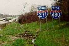
The freeway runs concurrently with I-271 for two miles (3.2 km). I-271 and I-480 are the only two three-digit Interstates in the nation that run concurrently with each other for any distance. This is because I-80 was concurrent with I-271 until 1971, when I-80 was routed back on to the turnpike and replaced by I-480.
Due to the convergence of these high traffic roads traffic jams are common during peak times. They run concurrently through Bedford Heights, Bedford, and Oakwood in Cuyahoga County.
The Valley View Bridge, which is 212 feet (65 m) high and spans 4,150 feet (1,260 m),[4] carries I-480 across the Cuyahoga River valley.
History
I-480 was conceived as a means of giving motorists a faster way of crossing Cleveland's southern borders and suburbs.[5][6] The first segment of the route was partially concurrent with I-271, and constructed simultaneously with that highway in 1965.[7] Planning for the route was largely finished by 1968, and construction began on its first mile began at the highway's interchange with I-77 in 1970.[6]
The segment from Bedford west to Maple Heights opened in November 1976.[8] The segment from Maple Heights west to Brooklyn Heights opened in January 1978.[9]
Construction from west to east began as political controversies and engineering work were resolved on the highway's middle section. I-480 between I-80 and I-71 was completed in 1983.[10]
The two miles (3.2 km) of the route north and northeast of Cleveland Hopkins International Airport proved the most difficult to plan due to existing high levels of traffic on Brookpark Road and the expansion requirements of the airport.[6]
The final $115 million (equivalent to $249 million in 2018[11]),[12] 2.5-mile (4.0 km) segment linking the east and west ends of I-480 was finished in August 1987.[13]
Exit list
| County | Location | mi | km | Exit | Destinations | Notes |
|---|---|---|---|---|---|---|
| Lorain | North Ridgeville | 0.00 | 0.00 | — | Exit 151 on I-80 / Turnpike | |
| 0.90 | 1.45 | Ohio Turnpike Toll Plaza | ||||
| 1.16 | 1.87 | 1 | Western end of SR 10 concurrency; westbound exit and eastbound entrance | |||
| 2.03 | 3.27 | 2 | Eastern end of SR 10 concurrency | |||
| Cuyahoga | North Olmsted | 3.67 | 5.91 | 3 | Stearns Road | |
| 6.15 | 9.90 | 6 | Signed as exits 6A (south) and 6B (north) westbound | |||
| 7.57 | 12.18 | 7 | Clague Road – Westlake, Fairview Park | Westbound exit and eastbound entrance | ||
| Cleveland | 9.44 | 15.19 | 9 | Eastbound ramps to SR 17; westbound to Grayton Road | ||
| 10.17 | 16.37 | 11 | Eastbound exit and westbound entrance; exit 238 on I-71 | |||
| 10.17 | 16.37 | 10 | Westbound exit and eastbound entrance | |||
| 10.71 | 17.24 | 11 | No eastbound exit; exit 238 on I-71 | |||
| 11.60 | 18.67 | 12A | West 150th Street — Brook Park | Westbound exit only | ||
| 12.71 | 20.45 | 12B | West 130th Street / West 150th Street — Brook Park | 150th Street not signed westbound; signed as exit 12 eastbound | ||
| Brooklyn | 13.79 | 22.19 | 13 | Tiedeman Road — Brooklyn | ||
| Cleveland | 15.21 | 24.48 | 15 | |||
| 16.49 | 26.54 | 16 | ||||
| 17.76 | 28.58 | 17A | Signed as exit 17 eastbound; exit 16 on SR 176 | |||
| Brooklyn Heights | 18.03 | 29.02 | 17B | Westbound exit and eastbound entrance | ||
| Independence | 20.05 | 32.27 | 20 | Exit 156 on I-77; signed as exits 20A (south) & 20B (north) | ||
| Cuyahoga River | 20.59– 21.39 | 33.14– 34.42 | Valley View Bridge | |||
| Garfield Heights | 21.72 | 34.95 | 21 | Transportation Boulevard / East 98th Street | ||
| 22.92 | 36.89 | 22 | Eastbound exit and westbound entrance; no entrance from SR 17 east | |||
| 23.85 | 38.38 | 23 | ||||
| Cleveland | 24.58 | 39.56 | 24 | Lee Road – Maple Heights | Westbound exit and eastbound entrance | |
| Warrensville Heights | 26.03 | 41.89 | 25A-B | Warrensville Road — Bedford, Warrensville Heights | Eastbound exit and westbound entrance; signed as exits 25A (south) and 25B (north) | |
| Warrensville Heights–Bedford Heights line | 26.03– 26.55 | 41.89– 42.73 | 25C | Eastbound access via frontage roads originating from exit 25A | ||
| 26.31 | 42.34 | 26 | Eastbound exit and westbound entrance via I-480N | |||
| Bedford Heights | 27.94 | 44.97 | 26A | Rockside Road | Westbound exit and eastbound entrance | |
| 28.02 | 45.09 | 26B | Western end of I-271 concurrency; eastbound exit via exit 26 | |||
| Oakwood | 30.99 | 49.87 | 23 | Western end of SR 14 concurrency | ||
| 32.06 | 51.60 | 21 | Eastern end of I-271 concurrency; eastbound exit and westbound entrance | |||
| Summit | Twinsburg | 36.30 | 58.42 | 36 | ||
| 36.99 | 59.53 | 37 | ||||
| Portage | Streetsboro | 41.63 | 67.00 | 41 | Frost Road | |
| 42.45 | 68.32 | 42 | Eastern end of SR 14 concurrency | |||
| – | Exit 187 on I-80 / Turnpike | |||||
1.000 mi = 1.609 km; 1.000 km = 0.621 mi
| ||||||
Interstate 480N
| |
|---|---|
| Location | Maple Heights–Warrensville Heights |
| Length | 1.99 mi[14] (3.20 km) |
| Existed | 1974–present |
The spur freeway connecting I-480 to I-271 and US 422 is officially designated as Interstate 480N, by the Ohio Department of Transportation.[15][16] It is currently signed as I-480 on interchange signs, and is signed as I-480N on mile markers.[17]
- Major intersections
The entire route is in Cuyahoga County.
| Location | mi[14] | km | Exit | Destinations | Notes |
|---|---|---|---|---|---|
| Maple Heights | 0.00 | 0.00 | – | Exit 26 on I-480 | |
| North Randall | 0.53– 0.78 | 0.85– 1.26 | 1 | Miles Road – North Randall, Bedford Heights | |
| Warrensville Heights | 1.29 | 2.08 | — | Eastbound exit and westbound entrance | |
| 1.63 | 2.62 | – | Westbound exit and eastbound entrance; exit 27A on I-271; exit 13A on US 422 | ||
| — | Eastbound exit and westbound entrance; exit 27B on I-271 | ||||
| 1.99 | 3.20 | – | Exit 13B on US 422 | ||
| 1.000 mi = 1.609 km; 1.000 km = 0.621 mi | |||||
References
- McIntyre, Michael K. (September 22, 1998). "I-480 Is Renamed in Honor of Glenn". The Plain Dealer. Cleveland. Retrieved April 12, 2010 – via Newsbank.
- Federal Highway Administration (October 31, 2002). "Table 2: Auxiliary Routes of the Dwight D. Eisenhower National System of Interstate and Defense Highways as of October 31, 2002". Route Log and Finder List. Federal Highway Administration. Retrieved October 5, 2014.
- Ohio Department of Highways (1958). "Cleveland" (Map). 1957–1958 Biennial Report. Scale not given. Columbus: Ohio Department of Highways. Retrieved April 2, 2008 – via Roadfan.com.
- kurumi (November 7, 2005). "Interstate 480". kurumi.com. Retrieved August 27, 2017.
- Cuyahoga County, Ohio (April 1961). "Route Location Studies: Outer Belt South Freeway, Broadview Road to Outer Belt East Freeway (Report Number 3)". Howard, Needles, Tammen & Bergendoff. Retrieved December 6, 2017.
- Kelly, Michael (March 29, 1970). "Hopkins' Needs Impede Freeway". The Plain Dealer. Cleveland. pp. A1, A13.
- Thoma, Pauline (August 13, 1976). "I-480 Two Years Late". The Plain Dealer. Cleveland. p. B2.
- "Ramps to Broadway at I-480 Will Open". The Plain Dealer. Cleveland. November 17, 1976. p. 7.
- "Snow Is Spreading Its Misery". The Plain Dealer. Cleveland. January 21, 1978. pp. A1, S6.
- Thoma, Pauline (August 12, 1984). "For a Freeway, I-480 Creeps". The Plain Dealer. Cleveland. p. A23.
- Thomas, Ryland; Williamson, Samuel H. (2019). "What Was the U.S. GDP Then?". MeasuringWorth. Retrieved April 6, 2019. United States Gross Domestic Product deflator figures follow the Measuring Worth series.
- Diemer, Tom (March 18, 1983). "City–State Pact Frees Road Funds". The Plain Dealer. Cleveland. p. B22.
- "Station Manager Pumped Up Over I-480". The Plain Dealer. Cleveland. August 9, 1987. p. A18.
- "Technical Services Straight Line Diagrams". Ohio Department of Transportation. Retrieved April 25, 2013.
- "Technical Services Straight Line Diagram for I-480N" (PDF). Ohio Department of Transportation.
- "Cuy". ODOT Routes in Cuyahoga County. Retrieved December 31, 2015.
- Google (August 2016). "I-480N mile marker". Google Street View. Google. Retrieved May 15, 2017.
External links
| Wikimedia Commons has media related to Interstate 480 (Ohio). |
| ||
| ||