Indigenous Protected Area
An Indigenous Protected Area (IPA) is a class of protected area used in Australia; each is formed by agreement with Indigenous Australians, and declared by Indigenous Australians. Each is formally recognised by the Australian Government as being part of its National Reserve System,[1][2] with 75 IPAs comprising more than 44% of the national reserve land, occupying about 67,000,000 hectares (170,000,000 acres) as of April 2020.[3]
By agreeing to establish Indigenous Protected Areas, Aboriginal Australians and Torres Strait Islanders contributed two-thirds of all new additions to Australia's National Reserve System over the decade 1997–2007.[4]
Indigenous rangers are employed to work in IPAs as well as in other remote areas of Australia, on land management and related projects.[5]
History
During the 1990s the Australian Government was working in cooperation with State and Territory Governments to build a National Reserve System aimed at protecting, for future generations, a representative sample of Australia's diverse range of flora, fauna and eco-systems.[4]
As part of this effort, Aboriginal Australian and Torres Strait Islander owners of lands and seas were asked, and many who were interested in re-establishing effective indigenous land management agreed to participate in this endeavour.[4]
At a national conference of Aboriginal Australians and Torres Strait Islanders held in 1997, it was agreed and resolved by the delegates present that a new class of 'indigenous' protected area should be formed as follows:[6]
"An Indigenous Protected Area is [to be] governed by the continuing responsibilities of Aboriginal and Torres Strait Islander peoples to care for and protect lands and waters for present and future generations."
"Indigenous Protected Areas may include areas of land and waters over which Aboriginal and Torres Strait Islanders are custodians, and which shall be managed for cultural biodiversity and conservation, permitting customary sustainable resource use and sharing of benefit."
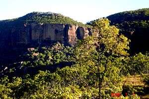
The first trialing of this new environmental partnership aimed at adding the new class of Protected Areas to Australia's National Reserve System, was with the Adnyamathanha people of Nepabunna Aboriginal community volunteering 580 square kilometres of rugged limestone hills, siltstone flats, springs and waterholes between the Flinders Ranges and Gammon Ranges National Parks to be managed as an Indigenous Protected Area.[4][7]
The land selected for the first proposed Indigenous Protected area was held by the South Australian Aboriginal Lands Trust, and, by 26 August 1998, an agreement had been reached to see the Adnyamathanha people of Nepabunna Aboriginal community engaged and some employed in restoring the landscape to its former natural and cultural value, and Australia's first Indigenous Protected Area, the Nantawarrina Indigenous Protected Area was declared.[7]
By 2007 the kind of partnership agreed and started with the Nantawarrina Indigenous Protected Area had grown to include 23 declared Indigenous Protected Areas covering close to 170,000 square kilometres or 23 per cent of the National Reserve System.[4]
In July 2012, The Nature Conservancy, alongside IPA alongside the Central Land Council and government representatives from Australia’s National Reserve System, helped announce the launch of the Southern Tanami Indigenous Protected Area.This Indigenous Protected Area is Australia’s largest land reserve, spanning 10.15 million hectares.[8] It protects important pieces of the Northern Territory’s natural legacy. Included in the Southern Tanami reserve are much of Lake Mackay—Australia’s second-largest lake—and an enormous swath of the Tanami Desert. This IPA links a variety of habitats that includes deserts and savannas, giving plant and animal species the space they need to maneuver around threats like wildfires and climate change.[9]
Criteria
Aboriginal Australian and Torres Strait Islander land and sea owners (including native title holders) may be encouraged, or themselves apply to the Australian Government to establish an Indigenous Protected Area on their lands/seas. However, an Indigenous Protected Area can only come into existence where:[1]
- land and/or seas are owned by Aboriginal Australians or Torres Strait Islanders; and
- significant biodiversity occurs within such Aboriginal/Torres Strait Islander owned lands or seas; and
- the Aboriginal Australians or Torres Strait Islanders concerned enter into a formal conservation agreement with the Australian Government to manage some of their lands or seas as an IUCN standard "protected area".
IPA data
IPA data is available online from several sources.
- Department of Environment IPA Database.[10] AT 3 February 2017, latest data file was 20 September 2016. Data is not well maintained – for example the gazetted area value for several IPAs is zero.
- Department of Environment Collaborative Australian Protected Area Database (CAPAD).[11] CAPAD data is not updated in real time, but is infrequently updated on a two year schedule. At February 2017, the last available update was in 2014. Data values may be incorrect/out of date. For example some values have not been updated/corrected for 10 years.
- Department of Prime Minister and Cabinet Indigenous Affairs online IPA and Indigenous Ranger map.[12] Data provided is incomplete, inaccurate, and locations for several smaller IPAs are incorrect on the map.
- Protected Planet's World Database on Protected Areas (WDPA)[13]
List of Indigenous Protected Areas
Federal
- Booderee National Park and Botanic Gardens, in the Jervis Bay Territory, managed by the Wreck Bay Aboriginal Community[14][15]
New South Wales
The following IPAs have been declared in New South Wales:[16]
- Brewarrina Ngemba Billabong Indigenous Protected Area
- Boorabee and The Willows Indigenous Protected Area
- Gumma Indigenous Protected Area
- Minyumai Indigenous Protected Area
- Ngunya Jargoon Indigenous Protected Area
- Tarriwa Kurrukun Indigenous Protected Area
- Toogimbie Indigenous Protected Area
- Wattleridge Indigenous Protected Area
- Weilmoringle Indigenous Protected Area
Northern Territory
The following IPAs have been declared in the Northern Territory:[17]
- Angas Downs Indigenous Protected Area
- Anindilyakwa Indigenous Protected Area
- Dhimurru Indigenous Protected Area – declared in 2000, it was the first land/sea IPA in Australia[18]
- Djelk Indigenous Protected Area
- Karlu Karlu / Devils Marbles Conservation Reserve ?
- Katiti Petermann Indigenous Protected Area - declared on 1 October 2015, more than 5,000,000 hectares (12,000,000 acres) in Uluṟu-Kata Tjuṯa National Park.[19]
- Laynhapuy Indigenous Protected Area - 600,000 hectares (1,500,000 acres), created in 2006[20]
- Marri-Jabin | Stage one of the Thamarrurr Indigenous Protected Area
- Northern Tanami Indigenous Protected Area
- Southern Tanami Indigenous Protected Area
- Warddeken Indigenous Protected Area
- Yanyuwa Indigenous Protected Area
Queensland
The following IPAs have been declared in Queensland:[21]
- Eastern Kuku Yalanji Indigenous Protected Area
- Guanaba Indigenous Protected Area
- Kaanju Ngaachi Wenlock and Pascoe Rivers Indigenous Protected Area
- Mandingalbay Yidinji Indigenous Protected Area
- Warul Kawa Indigenous Protected Area
South Australia
The following IPAs have been declared in South Australia:[22]
- Antara-Sandy Bore Indigenous Protected Area
- Kalka-Pipalyatjara Indigenous Protected Area
- Mount Willoughby Indigenous Protected Area
- Nantawarrina Indigenous Protected Area
- Watarru and Walalkara Indigenous Protected Area
- Yalata Indigenous Protected Area
Tasmania
The following IPAs have been declared in Tasmania:[23]
- Preminghana Indigenous Protected Area
- Risdon Cove and Putalina Indigenous Protected Areas
- Mount Chappell and Badger Islands Indigenous Protected Areas
Victoria
The following IPAs have been declared in Victoria:[24][25][26]
- Deen Maar Indigenous Protected Area
- Framlingham Forest Indigenous Protected Area
- Kurtonitj Indigenous Protected Area
- Lake Condah Indigenous Protected Area
- Tyrendarra Indigenous Protected Area
Western Australia
The following IPAs have been declared in Western Australia:[27]
- Balanggarra Indigenous Protected Area
- Bardi Jawi Indigenous Protected Area
- Birriliburu Indigenous Protected Area – over 66,000 square kilometres (25,000 sq mi)[28]
- Dambimangari Indigenous Protected Area
- Kiwirrkurra Indigenous Protected Area – 43,000 square kilometres (17,000 sq mi), established 2014[29]
- Matuwa and Kurrara Kurrara Indigenous Protected Area
- Ninghan Indigenous Protected Area
- Ngaanyatjarra Indigenous Protected Area
- Paruku Indigenous Protected Area
- Uunguu Indigenous Protected Area
- Warlu Jilajaa Jumu Indigenous Protected Area
2020: New IPAs
As of 2020, there are 20 new proposed IPAs under consultation at the following locations:[30]
- Tiwi Islands, north of Darwin, Northern Territory (Tiwi Land Council)
- Haasts Bluff, south-west Northern Territory (Central Land Council)
- Mamu Wet Tropics, far north Queensland (Mamu Aboriginal Corporation)
- Arafura Swamp, north-east Arnhem Land, Northern Territory (Arafura Swamp Rangers Aboriginal Corporation)
- Maralinga Tjarutja Lands, western South Australia (Oak Valley (Maralinga) Aboriginal Corporation)
- Mimal, south-east Arnhem Land, Northern Territory (Mimal Land Management).[31][32]
- Wuthathi Shelburne Bay, Cape York Peninsula, Queensland (Wuthathi Aboriginal Corporation)
- Ngururrpa, south-east Kimberley, Western Australia (Desert Support Services, on behalf of Parna Ngururrpa Aboriginal Corporation)
- Ngadju, north of Esperance, Western Australia (Ngadju Conservation Aboriginal Corporation)
- Olkola, central Cape York Peninsula, Queensland (Olkola Aboriginal Corporation)
- Crocodile Islands Maringa, north-east Arnhem Land, Northern Territory (Milingimbi & Outstations Progress Resource Association)
- Spinifex Pilki, south-east Western Australia (Pila Nguru Aboriginal Corporation)
Awards
The World Future Council (WFC) awarded the Indigenous Protected Areas and Indigenous Rangers programs with the"Bronze Future Policy Award 2017: Desertification".[33][34]
See also
- Aboriginal reserve
- Community Conservation Areas
- Indian reservation (US)
- Indian reserve (Canada)
- Minister for Indigenous Australians
- Protected areas of Australia
- Territory of Traditional Natural Resource Use, in Russia
References
- "Fact Sheets: Indigenous Protected Areas". Department of the Environment, Water, Heritage and the Arts. 7 December 2007. Archived from the original on 23 July 2008. Retrieved 22 September 2012.
- "National Reserve System". Department of the Environment and Energy. Retrieved 16 August 2018.
- "Indigenous Protected Areas". Department of Agriculture, Water and the Environment. 18 February 2019. Retrieved 5 April 2020.
- Australian Government, Department of the Environment and Water Resources (May 2007), Growing up strong: The first 10 years of Indigenous Protected Areas in Australia (PDF), Canberra: Australian Government, ISBN 978-0-642-55352-2, retrieved 8 May 2008
- "Working on Country - National Indigenous Australians Agency". Indigenous Rangers. Retrieved 1 February 2020.
- "Background on Indigenous Protected Areas". Archived from the original on 23 July 2008.
- Australia, Parks. "Indigenous Protected Areas: Nantawarrina. Case study". Environment.gov.au. Retrieved 16 August 2018.
- "Australia's biggest protected area declared". ABC. 11 July 2012. Retrieved 3 March 2013.
- "A Stunning Accomplishment at Southern Tanami". The Nature Conservancy in Australia.
- Energy, Department of the Environment and (13 February 2013). "CAPAD: protected area data". Environment.gov.au.
- "Archived copy". Archived from the original on 2 February 2017. Retrieved 27 January 2017.CS1 maint: archived copy as title (link)
- "Protected Planet". Protectedplanet.net.
- "Caring for country - Indigenous Protected Areas land managers meet at Booderee". Department of the Environment and Energy. 22 March 2011. Retrieved 5 February 2020.
- Farrier, David; Adams, Michael (8 August 2017). "Indigenous -Government Co-Management of Protected Areas: Booderee National Park and the National Framework in Australia". Semantic Scholar. Retrieved 5 February 2020.
- "Declared Indigenous Protected Areas in New South Wales". Department of the Environment. Retrieved 26 May 2015.
- "Declared Indigenous Protected Areas in the Northern Territory". Department of the Environment. Retrieved 26 May 2015.
- "Dhimurru". Country Needs People. 1 August 2018. Retrieved 1 February 2020.
- "Katiti Petermann Indigenous Protected Area Declared". The Central Land Council. 1 October 2015. Retrieved 5 February 2020.
- "Indigenous Land and Sea Management Projects". Department of the Prime Minister and Cabinet. Retrieved 27 January 2016.
- "Declared Indigenous Protected Areas in Queensland". Department of the Environment. Retrieved 26 May 2015.
- "Declared Indigenous Protected Areas in South Australia". Department of the Environment. Retrieved 26 May 2015.
- "Declared Indigenous Protected Areas in Tasmania". Department of the Environment. Retrieved 26 May 2015.
- "Declared Indigenous Protected Areas in Victoria". Department of the Environment. Archived from the original on 10 April 2020. Retrieved 26 May 2015.
- "Indigenous land and sea management projects". National Indigenous Australians Agency. 26 October 2015. Retrieved 5 April 2020.
- "Framlingham Forest IPA". National Indigenous Australians AgencyVic Projects. 10 December 2015. Retrieved 5 April 2020.
- "Declared Indigenous Protected Areas in Western Australia". Department of the Environment. Retrieved 26 May 2015.
- "Birriliburru". Country Needs People. 1 August 2018. Retrieved 1 February 2020.
- "Kiwirrkurra". Country Needs People. 1 August 2018. Retrieved 1 February 2020.
- "Indigenous Protected Areas". Department of Agriculture, Water and the Environment. 18 February 2019. Retrieved 10 February 2020.
- "Mimal Land Management". Mimal Land Management. 2 May 2016. Retrieved 1 March 2020.
- Bardon, Jane (29 February 2020). "The gas field so big it could knock Australia off course from our climate target". ABC News (Background Briefing). Australian Broadcasting Corporation. Retrieved 1 March 2020.
- "Bronze Future Policy Award 2017: Desertification". Indigenous.gov.au. 24 August 2017. Retrieved 1 February 2020.
- "2017: Desertification". World Future Council. 11 September 2017. Retrieved 1 February 2020.
Further reading
- Australian Government. Department of the Environment and Water Resources (May 2007), Growing up strong: The first 10 years of Indigenous Protected Areas in Australia (PDF), Canberra: Australian Government, ISBN 978-0-642-55352-2
- Langton, Marcia; Ma Rhea, Zane; Palmer, Lisa (2005). "Community-Oriented Protected Areas for Indigenous Peoples and Local Communities" (PDF). Journal of Political Ecology. 12 (1): 23–50. doi:10.2458/v12i1.21672.
- "What are IPAs?". Country Needs People.
External links
- Official website
- "Indigenous land and sea management projects". National Indigenous Australians Agency. 26 October 2015. Interactive map
- Map of IPAs as of February 2020