India–Pakistan border
The Pakistan–India Border, known locally as the International Border (IB), is an international border running between Pakistan and India. The border runs from the Line of Control (LoC), which separates Indian-administered Kashmir from Pakistan-administered Kashmir, in the north, to the Rann of Kutch between the Indian state of Gujarat and the Sindh province of Pakistan, in the south.[1]
| Pakistan–India border | |
|---|---|
 Nighttime panorama of the border, stretching from the Arabian Sea to the foothills of the Himalayas | |
| Characteristics | |
| Entities | |
| Length | 3,323 kilometres (2,065 mi) |
| History | |
| Established | 17 August 1947 Creation of the Radcliffe Line by Sir Cyril Radcliffe due to the Partition of India |
| Current shape | 2 July 1972 Demarcation of the Line of Control after ratification of the Simla Treaty |
| Treaties | Karachi Agreement, Simla Agreement |
| Notes | The Line of Control separates Kashmir between India and Pakistan, it is not an internationally recognized border |
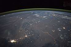
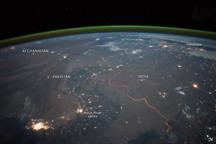
Drafted and created based upon the Radcliffe line in 1947, the border, which divides Pakistan and India from each other, traverses a variety of terrains ranging from major urban areas to inhospitable deserts.[2] Since the independence of India and Pakistan (see British India), the border has been a site of numerous conflicts and wars between each country, and is one of the most contested borders in the world.[2] The border's total length is 3,323 km (2,065 mi),[2] according to the figures given by the PBS; it is also one of the most dangerous borders in the world, based on an article written in the Foreign Policy in 2011.[3] It can be seen from space at night due to the 150,000 flood lights installed by India on about 50,000 poles.[4][5][6]
Working Boundary, Line of Control, and International Boundary
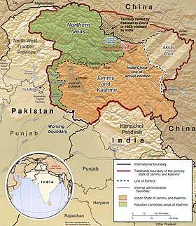
The border between the two Nations is an internationally recognised frontier from Gujarat/Sindh only with exemption to the Line of Control that is not internationally accepted. The disputed region of Kashmir got divided through the Indo-Pakistani War of 1947 into the regions of Pakistan-administered Kashmir and Indian-administered Kashmir. The UN-mediated ceasefire line of 1949 served as the de facto border between the two regions, which was revised to a Line of Control after the Indo-Pakistani War of 1971.[7]
The border between Indian-administered Kashmir and the Pakistani province of Punjab is officially called the "Working Boundary" by Pakistan. India regards it as the international border.[7]
- Working boundary: The line between Punjab Province of Pakistan along Sialkot and Indian controlled Kashmir. It is called a working boundary because on one side is an internationally recognised land (Sialkot) while on the other is a disputed territory.[7]
- Line of Control (LOC): Line of control is the boundary between the Pakistan-administered Kashmir and Indian-administered Kashmir. It was demarcated after the Simla pact in 1972.[7]
- International boundary: The demarcated line between the Republic of India and the Islamic Republic of Pakistan recognized internationally. Sir Cyril Radcliffe demarcated the land in 1947.[7]
Border crossings
- ICP Border crossings with designated Integrated Check Posts (ICP) with immigration and customs facilities are:
- Attari and Wagah, is the most famous and prominent border crossing point between India and Pakistan due to Wagah-Attari border ceremony. The crossing is located 32 kilometres from Amritsar and 24 kilometers from Lahore.
- Munabao : This village situated at Barmer district in Rajasthan, is famous for the railway station through which, the Thar Express connecting India with Pakistan runs. The crossing point had been closed after the Indo-Pakistani War of 1965. In February 2006 it was reopened and since then the Thar Express operates from Bhagat Ki Kothi in Jodhpur, India to Karachi, Pakistan.[8]
- Other crossings
- Ganda Singh Wala border, Kasur District (Pakistan side) / Hussainiwala border, Punjab (India side)
- Sulaimanki, Punjab (Pakistan side) / Fazilka border, Okara District (India side)
- Longewala (closed)
Wagah-Attari border ceremony
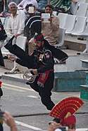
The flag lowering ceremony at the village of Wagah is held each evening immediately before sunset by the border agents of Pakistan (Pakistan Rangers) and India (Border Security Force or BSF).[9] It is a tradition dating back to 1959. The ceremony begins with battle calls from both sides in the form of loud screaming done by the border guards. This is followed by a series of organized high kicks, stomps, and dance moves during which the opposing forces stare each other down.[10] The event ends with a handshake of good faith being exchanged by the head guards along with the lowering of the flags.[10] The crowd cheers and claps enthusiastically through it all. The ritual is known to attract international tourists and even celebrities.[10] It is symbolic of the brotherhood as well as the rivalry that these two nations share.[10] The border troops are known to exchange sweets with the opposing side during the Muslim holidays of Eid and Hindu holiday of Diwali, but in 2016 and 2018 the BSF have avoided doing so due to rising military tensions. It has been a peaceful gathering with the exception of the 2014 Wagah border suicide attack in which 60 people were killed and over 110 people were left injured.[11] It has also been cancelled on occasion such as when Pakistan returned Wing Commander Abhinandan Varthaman back to India after his plane was shot down by the Pakistan Air Force (PAF) during the 2019 India-Pakistan standoff.[12]
Similar border ceremonies held by the India (Border Security Force, BSF) and Pakistan (Pakistan Rangers) occur at Fazilka border (India side) / Sulaimanki, Punjab and Hussainiwala border, Punjab (India side) / Ganda Singh Wala border, Kasur District (Pakistan side). These rituals are attended primarily by the local villagers and garner very few spectator tourists.
International relations
- China: Pakistan has a close and supportive relationship with China, with the People’s Republic of China providing economic, military, and technical assistance to Pakistan, and each country considers the other a close strategic ally. China is Pakistan’s largest supplier of weapons and one of its largest trading partners. There are strong military ties between China and Pakistan beyond the supply of weapons. This alliance between two neighboring Asian nations is significant geopolitically, as the strong military ties counter regional Indian and American influence. China-India disputes have emerged concerning land borders and economic competition that has led to strained relations. China even now supports Pakistan in the Pakistani-Indian conflicts but has partaken in virtually no combat on the physical border of China and India, preferring to work remotely through the Pakistani-Indian border. China has continued to support Pakistan in the argument over Kashmir even into the 2010s.[13]
- Afghanistan: See above section
Gallery
 "Baba Chamliyal Mela" at Pakistan-India international Border, Ramgarh sector, 45 km from Jammu, where people from both the nations take part.
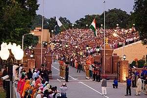 Evening flag lowering ceremony at the Wagah border (as seen from Pakistani side of the border).
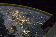 The floodlit border zone between Pakistan and India has a distinctly orange hue in this astronaut photograph.
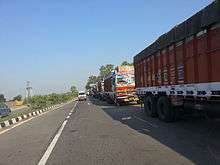 Trucks on National Highway 1 (India), waiting to cross Wagah border.
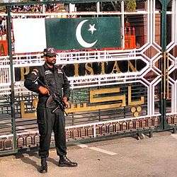 Punjab Rangers at the Wagah border.
 Women personnel of BSF taking part in the ceremonial retreat at the Pakistan-India border at Wagah, 2010.
See also
- Borders of India
- Radcliffe Line
- 2014–15 India–Pakistan border skirmishes
References
- Khan, MH (5 March 2006). "Back on track". Dawn News archives. Retrieved 15 April 2013.
- PBS Release (July 26, 2005). "Border Jumpers The World's Most Complex Borders: Pakistan/India". PBS. Retrieved 15 April 2013.
- PHILIP WALKER (June 24, 2011). "The World's Most Dangerous Borders". The Foreign Policy. Retrieved 15 April 2013.
- "Dailymail". Retrieved 23 October 2014.
- "India-Pakistan Borderlands at Night". India-Pakistan Border at Night. NASA. 23 September 2015. Retrieved 14 October 2015.
- "Annotated image from NASA".
- Library, C. N. N. "Kashmir Fast Facts". CNN. Retrieved 2019-04-20.
- "Radcliffe Line to divide India-Pakistan was formed this day: Read about it here". India Today. 17 August 2016. Retrieved 30 July 2018.
- Khaleeli, Homa (2010-11-01). "Goodbye to the ceremony of silly walks between India and Pakistan". The Guardian. ISSN 0261-3077. Retrieved 2019-04-19.
- Clark, Tawny. "India and Pakistan's beautiful border ritual". www.bbc.com. Retrieved 2019-04-20.
- "Pakistan border bombing kills dozens". 2014-11-03. Retrieved 2019-04-20.
- "Daily Retreat ceremony along Attari-Wagah border cancelled: BSF". The Economic Times. 2019-03-01. Retrieved 2019-04-20.
- "China firmly with Pakistan, says Beijing as Islamabad raises Kashmir in top talks". Hindustan Times. March 19, 2019.
External links

- "How this border transformed a subcontinent | India & Pakistan". Vox. 2019-06-26.
- International Boundary Study No. 86 – December 2, 1968 India – Pakistan Boundary
Template:Pakistan-India relations