Ichchapuram
Ichchapuram is a town in Srikakulam district of the Indian state of Andhra Pradesh. It is a Municipality and also the mandal headquarters of Ichapuram mandal.this town is located nearly 142 km from the district capital srikakulam.[4]
Ichchapuram | |
|---|---|
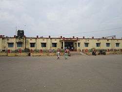 Ichchapuram railway station | |
.svg.png) Ichchapuram Location in Andhra Pradesh, India | |
| Coordinates: 19.12°N 84.7°E | |
| Country | India |
| State | Andhra Pradesh |
| District | Srikakulam |
| Government | |
| • Type | Municipality |
| • Body | Ichchapuram Municipality, SUDA |
| • Member of Legislative Assembly | Bendalam ashok |
| Area | |
| • Total | 27.28 km2 (10.53 sq mi) |
| Elevation | 15 m (49 ft) |
| Population (2011)[3] | |
| • Total | 40,000 |
| • Density | 1,500/km2 (3,800/sq mi) |
| Languages | |
| • Official | Telugu |
| Time zone | UTC+5:30 (IST) |
| PIN | 532 312 |
| Telephone code | +91–8947 |
| Lok Sabha constituency | Srikakulam |
| Vidhan Sabha constituency | Ichchapuram |
| Website | ichapuram |
Geography
Ichchapuram is located at the border of Andhra Pradesh and Odisha at 19.12°N 84.7°E.[5] It has an average elevation of 7 metres (22 feet). The town is located on the banks of Bahuda river.
Demographics
As of 2011 census, the town had a population of 36,493. The total population constitute, 17,716 males, 18,777 females and 4,004 children, in the age group of 0–6 years. The average literacy rate stands at 71.12% with 23,105 literates.[3] The spoken languages are both Telugu and Odia.
Government and politics
Ichchapuram municipality is classified as a 3rd grade municipality.[1] Ichapuram is an assembly constituency in Andhra Pradesh. Bendalam Ashok is the present MLA.[6]
Transport
National Highway 16, a part of Golden Quadrilateral highway network, bypasses the town.[7] Ichchapuram railway station is situated on the Howrah-Chennai main line.
Education
The primary and secondary school education is imparted by government, aided and private schools,like: Swarna Bharathi english medium school, & Gnana Bharathi english medium school & also Ravindra Bharathi english medium school. under the School Education Department of the state.[8][9]
See also
- List of municipalities in Andhra Pradesh
References
- "STATISTICAL INFORMATION OF ULBs & UDAs" (PDF). Directorate of Town and Country Planning. Government of Andhra Pradesh. p. 1. Retrieved 24 April 2019.
- "Elevation for Rajam". Veloroutes. Retrieved 19 August 2014.
- "Census 2011". The Registrar General & Census Commissioner, India. Retrieved 19 August 2014.
- "Srikakulam district mandals" (PDF). Census of India. The Registrar General & Census Commissioner, India. pp. 178, 210–11. Retrieved 18 May 2015.
- Falling Rain Genomics, Inc – Ichchapuram
- http://www.elections.in/andhra-pradesh/assembly-constituencies/ichchapuram.html
- "National Highways Development Project Map". National Highways Authority of India. Archived from the original on 22 April 2017. Retrieved 21 April 2017.
- "School Education Department" (PDF). School Education Department, Government of Andhra Pradesh. Archived from the original (PDF) on 27 December 2015. Retrieved 7 November 2016.
- "The Department of School Education – Official AP State Government Portal | AP State Portal". www.ap.gov.in. Archived from the original on 7 November 2016. Retrieved 7 November 2016.
External links
| Wikimedia Commons has media related to Ichchapuram. |
| District Headquarter | 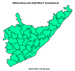 | |
|---|---|---|
| Revenue Divisions | ||
| Mandals |
| |
| Cities | ||
| Towns | ||
| Census Towns | ||
| Lok Sabha constituencies | ||
| Assembly constituencies |
| |