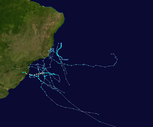
Hurricane Catarina
Hurricane Catarina or Cyclone Catarina (Portuguese pronunciation: [kataˈɾinɐ]) was an extremely rare South Atlantic tropical cyclone, the only recorded hurricane strength storm on record in the South Atlantic Ocean. It struck South Brazil at near peak intensity with the equivalent of Category 2 hurricane-force winds.
| Category 2 hurricane (SSHWS) | |
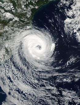 Hurricane Catarina approaching Brazil on March 27 | |
| Formed | March 24, 2004 |
|---|---|
| Dissipated | March 28, 2004 |
| Highest winds | 1-minute sustained: 155 km/h (100 mph) |
| Lowest pressure | 972 hPa (mbar); 28.7 inHg (Record low in the South Atlantic[1]) |
| Fatalities | 3–11 direct |
| Damage | $350 million (2004 USD) |
| Areas affected | Santa Catarina and Rio Grande do Sul, Southern Brazil |
| Part of the 2003–04 South Atlantic hurricane season | |
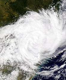
The storm developed out of a stationary cold-core upper-level trough on March 12. Almost a week later, on March 19, a disturbance developed along the trough and traveled towards the east-southeast until March 22 when a ridge stopped the forward motion of the disturbance. The disturbance was in an unusually favorable environment with a slightly below-average wind shear and above-average sea surface temperatures. The combination of the two led to a slow transition from an extratropical cyclone to a subtropical cyclone by March 24. The storm continued to obtain tropical characteristics and became a tropical storm the next day while the winds steadily increased. The storm attained wind speeds of 121 km/h (75 mph)—equivalent to a low-end Category 1 hurricane on the Saffir–Simpson scale—on March 26. At that time, it was unofficially named Catarina and was also the first hurricane-strength tropical cyclone ever recorded in the Southern Atlantic Ocean. Unusually favorable conditions persisted and Catarina continued to intensify, and was estimated to have peaked with 1-minute sustained winds of 160 km/h (100 mph) on March 28. The center of the storm made landfall between the cities of Passo de Torres and Balneário Gaivota, Santa Catarina. Catarina rapidly weakened upon landfall and dissipated later that day.
Since Catarina was the first tropical cyclone to make landfall in Brazil since the beginning of reliable records, and hence infrastructure and the population were not specifically prepared for it, the damage was quite severe. Although the storm was an unprecedented event, Brazilian officials took the appropriate actions and warned the public about the approaching storm. Residents heeded the warnings and prepared for the storm by either evacuating or by riding it out in their homes. Catarina ended up destroying 1,500 homes and damaging around 40,000 others. Agricultural products were severely damaged: 85% of the banana crops and 40% of the rice crops were lost in the storm. Three people were confirmed to have perished in the storm and 185 others were injured. Damages from the storm amounted to US$350 million (value in 2004).
Meteorological history
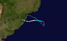
On March 12, a cold-core stationary upper-level trough became established offshore of southern Brazil. A disturbance formed within the trough on the 19th, and moved east-southeastward until the 22nd, when a ridge to its southeast kept it stationary. With exceptionally favorable upper level winds and slightly below average,[2] as well as marginally warm, water temperatures from 24 to 26 °C (75 to 79 °F), it gradually developed, resembling a subtropical storm by the 24th. Located 630 nautical miles (1,165 km; 725 mi) east-southeast of Florianópolis, it headed slowly westward, and appeared to become a tropical storm on March 25.[3]
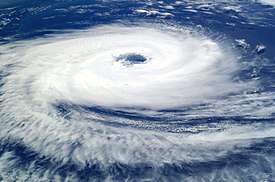
A compact storm, it continued westward while steadily intensifying. The structure of the storm continued to improve and due to a definite eye feature showing on satellites, the storm was determined to have become a hurricane-equivalent cyclone on March 26.[4] A Brazilian newspaper had a headline "Furacão Catarina" (i.e. "hurricane [threatening the state of Santa] Catarina"). Partly because of this headline, the storm was unofficially named Catarina. It continued to encounter favorable conditions and reached its peak intensity on early March 28, with a minimum central pressure of 972 millibars (28.7 inHg) and estimated 1-minute sustained winds of 160 km/h (100 mph), which made the storm the equivalent of a Category 2 hurricane on the Saffir–Simpson Hurricane Scale. Gusts peaked at around 190 km/h (120 mph). The hurricane made landfall on the southern coast of Santa Catarina and northeastern Rio Grande do Sul, with winds up to 195 km/h (121 mph) overnight. After making landfall, Catarina rapidly weakened over land, in the normal manner of a tropical cyclone, dissipating later that day.[3]
Naming
Brazilian meteorologists named the storm Catarina for its proximity to (and eventual landfall near) the state of Santa Catarina, although government forecasters initially denied that the storm, which clearly had an open eye and various other tropical morphologies, was a hurricane at all. More than a year after the storm made landfall, Brazilian meteorologists finally classified the storm as a tropical cyclone.[5]
North American forecasters, however surprised as they were, considered this storm a hurricane immediately upon reviewing the satellite-derived evidence. Since Catarina had a clear eyewall structure bounded by deep convective, dense central overcast, well-defined spiral outer bands and outflow structure, warm water temperatures of 26 °C (79 °F), little shear, a warm core low, overall tropical characteristics, and occurred in March (equivalent to September in the Northern Hemisphere, the peak of hurricane season), it was considered to be a hurricane by the National Hurricane Center (NHC) in the United States.[6]
Though it is most commonly known as Catarina, all names for this storm are "unofficial," in that no World Meteorological Organization (WMO)-affiliated meteorological agency that monitors hurricanes named it. (Tropical cyclone names are predetermined by an international committee of the WMO.)[7] It has also been unofficially called "Aldonça",[8] and the advisory names for it were "01T-ALPHA" from the United Kingdom's Met Office, and "50L-NONAME" from the United States' National Hurricane Center, which keeps it well outside normal designation, which start at 01L for named storms and use 90L to 99L for invests.[3]
Rare formation
Typically, tropical cyclones do not form in the South Atlantic Ocean, due to strong upper level shear, cool water temperatures, and the lack of a convergence zone of convection. Occasionally though, as seen in 1991 and early 2004, conditions can become slightly more favorable. For Catarina, it was a combination of climatic and atmospheric anomalies. Water temperatures on Catarina's path ranged from 24 to 25 °C (75 to 77 °F), slightly less than the 26.5 °C (79.7 °F) temperature of a normal tropical cyclone, but sufficient for a storm of baroclinic origin.[4]
Catarina remains the only hurricane strength tropical cyclone ever observed in the South Atlantic Ocean (reliable continuous and relatively comprehensive records only began with the satellite era beginning about 1970). Other systems have been observed in this region; however, none have reached hurricane strength, and no eyes were seen on satellite imagery or radar.[9] While Catarina formed in an unusual area, its relation to global warming or any other type of global climatic change is still up for debate. The Brazilian Society of Meteorology attributed it to "climatic changes and atmospheric anomalies,"[5] while other researchers have indicated that it could be the result of the Southern Annular Mode or other seasonal variations in weather within the Southern Hemisphere, again linked to global changes in climate.[10] However, more research in the area is still needed to make a conclusion.[10]
Impact

Like normal tropical cyclones, Catarina brought heavy flooding with it. Despite the uncertainty in the future of the storm, Brazilian officials took the appropriate actions to ensure the safety of the residents who lived along the coastline. A successful evacuation was executed for numerous residents along the coast, though some people decided to ride out the storm in their own homes.[4] The storm damaged around 40,000 homes and destroyed 1,500; 40% of the rice crop were also lost. Total damages were estimated at $350 million (2004 USD). It also killed at least three and injured at least 75. At least 2,000 people were left homeless following the storm.[11]
At Passo de Torres, many shipyards were destroyed, as they were not designed to withstand the pressure differentials caused by Catarina's winds; widespread roof damage was reported at this municipality as well.[12] Near the Mampituba River, a house was blown about 50 m (160 ft) upstream, literally landing in another state: it originally was built in the Torres municipality of Rio Grande do Sul, yet it ended up in Passo de Torres, within Santa Catarina. In rural areas, the corn, banana, and rice fields received the most damage, although rice farmers were able to partially recoup their losses, as they had harvested before Catarina made landfall.[12]
Overall, almost 36,000 residences were damaged as a result of Catarina's onslaught; of those, 993 collapsed completely. The commercial sector fared slightly better, as only 2,274 buildings were damaged and 472 collapsed. Finally, 397 public buildings were damaged and three were destroyed. These account for 26% of the total buildings in the region, which amounted to property damage of US$25.6 million (value in 2004). Four-fifths of the damaged houses had some sort of roof failure or collapse. Most of the damage was blamed on the low quality of the construction; brick residences typically lacked plaster, beams, or columns, for example. The areas affected the most were those inhabited by low-income families, usually with annual family salaries of less than US$400.[12]
See also
| Wikimedia Commons has media related to Hurricane Catarina. |
- Subtropical Storm Arani (2011) – The first system officially named by the Brazilian Navy
- Mediterranean tropical-like cyclones
- Unusual areas of tropical cyclone formation
- 2006 Central Pacific cyclone
- 1996 Lake Huron cyclone
- Subtropical Cyclone Katie
- Subtropical Cyclone Lexi
References
- McTaggart-Cowan, R., Bosart, L. F., Davis, C. A., Atallah, E. H., Gyakum, J. R., and Emanuel, K. A. (November 2006). "Analysis of Hurricane Catarina (2004)". Monthly Weather Review. 134 (11): 3029–53. Bibcode:2006MWRv..134.3029M. doi:10.1175/MWR3330.1.CS1 maint: multiple names: authors list (link)
- OSDPD, NOAA. "NOAA/NESDIS 50 KM GLOBAL ANALYSIS: SST — Climatology (C), 3/23/2004". The Office of Satellite Data Processing and Distribution. National Oceanic and Atmospheric Administration. Retrieved 6 March 2010.
- Gary Padgett (2004). "March 2004 Tropical Cyclone Summary". Thomas R. Metcalf (Australian Severe Weather). Retrieved 2008-10-23.
- Bob Henson (2005). "What was Catarina?". UCAR Communications. Archived from the original on 2016-06-03. Retrieved 2008-10-20.
- "Phenomenon Catarina in Debate". Informativo. Sociedade Brasileira de Meteorologia. July 2005. Archived from the original on 2007-07-01. Retrieved 2006-12-24.
- "Tropical Weather Discussion". National Hurricane Center. Retrieved 2012-12-03.
- "Worldwide Tropical Cyclone Names". National Hurricane Center. Archived from the original on 2010-12-07. Retrieved 2008-10-21.
- NLMRY (March 2004). "Hurricane Catarina/Aldonca — Rare South Atlantic Hurricane". Phil Smith. Archived from the original on 2008-09-22. Retrieved 2008-10-21.
- Department of Meteorology, e-Education Institute. "Upper-Level Lows". Meteorology 241: Fundamentals of Tropical Forecasting. Pennsylvania State University. Archived from the original on 2016-03-03. Retrieved 2006-10-24.
- Pessa, Alexandre B.; Ian Simmonds (April 2006). "Catarina: The First South Atlantic Hurricane and its Association with Vertical Wind Shear and High Latitude Blocking" (PDF). 8th International Conference on Southern Hemisphere Meteorology and Oceanography. University of Melbourne. Archived from the original (PDF) on June 16, 2007. Retrieved 2006-12-24.
- Jefferson Bernardes (March 30, 2004). "First South Atlantic hurricane hits Brazil". USA Today. Retrieved February 23, 2009.
- Marcelino, Emerson Vieira; Isabela Pena Viana de Oliveira Marcelino; Frederico de Moraes Rudorff (2004). "Cyclone Catarina: Damage and Vulnerability Assessment" (PDF). Santa Catarina Federal University. Archived from the original (PDF) on March 3, 2016. Retrieved December 24, 2006.
Further reading
- McTaggart-Cowan, Ron; Lance F. Bosart; Christopher A. Davis; Eyad H. Atallah; John R. Gyakum; Kerry A. Emanuel (November 2006). "Analysis of Hurricane Catarina (2004)". Monthly Weather Review. 134 (11): 3029–3053. Bibcode:2006MWRv..134.3029M. doi:10.1175/MWR3330.1.
- Marcelino, Emerson Vieira; Isabela Pena Viana de Oliveira Marcelino; Frederico de Moraes Rudorff (2005). "Cyclone Catarina: Damage and Vulnerability Assessment" (PDF). Divisão de Sensoriamento Remoto. Archived from the original (PDF) on 2016-03-03. Retrieved 2006-12-24. Cite journal requires
|journal=(help) - Pezza, Alexandre B.; Ian Simmonds (April 2006). "Catarina: The First South Atlantic Hurricane and its Association with Vertical Wind Shear and High Latitude Blocking" (PDF). Proceedings of the 8th International Conference on Southern Hemisphere Meteorology and Oceanography. Foz do Iguaçu, Brazil: Instituto Nacional de Pesquisas Espaciais. pp. 353–364. Archived from the original (PDF) on 2007-06-16.
- Filho, Augusto José Pereira; Raquel Silva Lima (April 2006). "Synoptic and Mesoscale Analysis of Hurricane Catarina, Brazil" (PDF). Proceedings of the 8th International Conference on Southern Hemisphere Meteorology and Oceanography. Foz do Iguaçu, Brazil: Instituto Nacional de Pesquisas Espaciais. pp. 1901–1907. Archived from the original (PDF) on 2007-11-28.
- Filho, Augusto José Pereira; Alexandre Bernardes Pezza; Ian Simmonds; Raquel Silva Lima; Marcio Vianna (February 2010). "New perspectives on the synoptic and mesoscale structure of Hurricane Catarina". Atmospheric Research. 95 (2–3): 157–71. Bibcode:2010AtmRe..95..157P. doi:10.1016/j.atmosres.2009.09.009.
- Levinson, David H. (June 2005). "State of the Climate in 2004". Bulletin of the American Meteorological Society. 86 (6): S1–S86. Bibcode:2005BAMS...86....1L. doi:10.1175/BAMS-86-6-Levinson.
- Pezza, Alexandre Bernardes; Simmonds, Ian; Filho, Augusto Jose Pereira (2008). "Climate perspective on the large-scale circulation associated with the transition of the first South Atlantic hurricane". International Journal of Climatology. 29 (8): 1116–30. Bibcode:2009IJCli..29.1116P. doi:10.1002/joc.1757. Archived from the original on 2013-01-05. Retrieved 2010-06-09.
External links
| Wikimedia Commons has media related to Hurricane Catarina. |
- Informal studies and summary pages
- Penn State write-up
- Workshop on the Phenomenon Catarina (Brazilian Society of Meteorology)
- Hurricane Catarina (Cooperative Institute for Meteorological Satellite Studies (CIMSS))
- NOAA satellite and Dvorak info
- Rare South Atlantic Tropical Cyclone (NASA)
- Media