Hurricane Agnes tornado outbreak
The 1972 Hurricane Agnes tornado outbreak was the third-deadliest tropical cyclone-related outbreak in the United States since 1900, as well as the deadliest such tornado outbreak on record in Florida.[nb 2] The outbreak, produced by Hurricane Agnes, lasted about thirty-eight hours on June 18–19, 1972.[nb 3] Two of the tornadoes killed a total of seven people and were not classified as tornadoes by the National Weather Service until 2018. In Florida alone, the outbreak inflicted at least 135 injuries and destroyed fifteen homes, while 119 homes received damage. Statewide, 217 trailers were destroyed and 196 trailers incurred damage. Additionally, six businesses were destroyed, while six others were damaged.[4]
Part of the tornadoes of 1972 | |
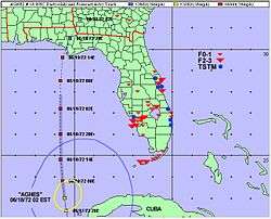
.jpg) Damage from an F2 tornado in Key West, Florida | |
| Type | Tornado outbreak Tropical cyclone |
|---|---|
| Duration | June 18–19, 1972 |
| Tornadoes confirmed | 19 confirmed |
| Max. rating1 | F3 tornado |
| Duration of tornado outbreak2 | 1 day, 13 hours, 45 minutes |
| Damage | $ (1972 USD)[nb 1] |
| Casualties | 7 fatalities, ≥135 injuries |
| Areas affected | Florida and Georgia |
| 1Most severe tornado damage; see Fujita scale 2Time from first tornado to last tornado | |
Background
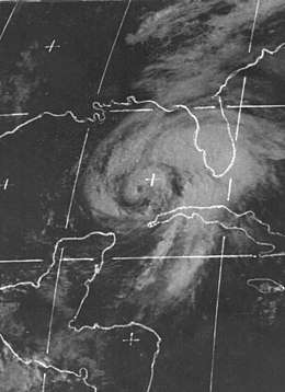
The interaction of baroclinic features with Agnes resulted in a tropical cyclone with "hybrid" characteristics, which increased the threat of strong tornadoes with longer path lengths.[8][9] The outbreak became the most significant tornado outbreak associated with a tropical cyclone prior to landfall.[4] The presence of strong wind shear surrounding the tropical cyclone facilitated the development of strong tornadoes, including the greatest number of tornadoes of at least F2 intensity within one 24-hour period in Florida.[4][8] Studies have suggested strong wind shear in the lower levels of the atmosphere is a common feature during tornado outbreaks involving the outer rain bands of tropical cyclones near Florida.[1] Additionally, in Florida cases, the favored region for tornado outbreaks is the northeastern quadrant of northward-moving tropical cyclones. Agnes represented one of these cases.[1][10]
Daily statistics
| FU | F0 | F1 | F2 | F3 | F4 | F5 | Total |
|---|---|---|---|---|---|---|---|
| 0 | 1 | 7 | 9 | 2 | 0 | 0 | 19 |
| "FU" denotes unclassified but confirmed tornadoes. | |||||||
- A number of undocumented tornadoes were located in 2002, but were overlooked at the time of the outbreak. For example, a brief tornado struck Everglades City. Trees were prostrated and portions of a home were transported for 1⁄4 mi (0.40 km).[11][4] Additionally, a brief tornado damaged a roof and two airplanes in the town of Immokalee. Power lines were downed in the area.[11][4]
| Date | Total | Fujita scale rating | Deaths | Injuries | Damage | Ref. | ||||||
|---|---|---|---|---|---|---|---|---|---|---|---|---|
| FU | F0 | F1 | F2 | F3 | F4 | F5 | ||||||
| June 18 | 13 | 0 | 1 | 5 | 7 | 0 | 0 | 0 | 1 | 67 | $ | [12][6][13][4] |
| June 19 | 6 | 0 | 0 | 2 | 2 | 2 | 0 | 0 | 6 | 68 | $ | [12][6][7][13][4] |
| Total | 19 | 0 | 1 | 7 | 9 | 2 | 0 | 0 | 7 | 135 | $ | [12][6][7][13][4] |
| State | Total | County | County total | ||
|---|---|---|---|---|---|
| Florida | 7 | Hendry | 1 | ||
| Okeechobee | 6 | ||||
| Totals | 7 | ||||
| All deaths were tornado-related | |||||
List of tornadoes
| F# | Location | County / Parish | State | Start coord. |
Date | Time (UTC) | Path length | Max. width | Summary |
|---|---|---|---|---|---|---|---|---|---|
| F2 | Big Coppitt Key | Monroe | FL | 24.62°N 81.68°W | June 18 | 06:15–? | 1 mile (1.6 km) | N/A | The first tornado of the outbreak touched down on Geiger Key and headed north-northwestward onto Big Coppitt Key.[15] In all, forty-seven trailers and five homes incurred damage. One frame residence lost its roof.[13] Losses totalled $342,000,[15] and forty people were injured.[16] |
| F2 | Key West | Monroe | FL | 24.57°N 81.80°W | June 18 | 07:00–? | 1.5 miles (2.4 km) | N/A | Buildings were destroyed and unroofed on the northern side of Key West.[13] Losses amounted to $400,000.[15] |
| F1 | Conch Key | Monroe | FL | 24.83°N 80.88°W | June 18 | 10:00–? | 2 miles (3.2 km) | N/A | The majority of the damage occurred on Conch Key, where the tornado damaged six trailers. Losses amounted to less than $10,000.[15] |
| F1 | NNE of Basinger | Okeechobee | FL | 27.43°N 81.00°W | June 18 | 17:55–? | 1 mile (1.6 km) | N/A | This tornado first impacted U.S. Route 98 and damaged or destroyed six mobile homes. Two individuals received injuries,[17] and damages totalled $20,000.[15] |
| F2 | WSW of Sanibel | Lee | FL | 26.43°N 82.12°W | June 18 | 18:38–? | 0.3 miles (0.48 km) | N/A | Five stores and the roof of a church were destroyed. Losses reached $15,000.[15] Grazulis did not list this tornado as an F2 or stronger.[13] |
| F2 | Pine Island | Lee | FL | 26.62°N 82.17°W | June 18 | 19:00–? | 2 miles (3.2 km) | N/A | This tornado passed through three trailer parks and destroyed four mobile homes. Several stores received damage as well. Losses were near $50,000.[18] Grazulis did not list this tornado as an F2 or stronger.[13] |
| F1 | NNE of Lake Alfred | Polk | FL | 28.13°N 81.70°W | June 18 | 19:10–? | 0.3 miles (0.48 km) | N/A | This tornado struck the Haines City Mobile Home Park and severely damaged six mobile homes.[18] Three minor injuries occurred,[19] and damages reached $43,000.[18] |
| F2 | Lehigh Acres | Lee | FL | 26.62°N 81.63°W | June 18 | 20:00–? | 0.5 miles (0.80 km) | N/A | A brief tornado struck and destroyed a television transmission tower. Damages were estimated at $60,000.[18] Grazulis did not list this tornado as an F2 or stronger.[13] |
| F2 | S of Fort Denaud to WNW of LaBelle | Hendry, Glades | FL | 26.73°N 81.47°W | June 18 | 21:13–? | 3.5 miles (5.6 km) | N/A | One death – This strong tornado killed a woman as it wrecked her mobile home in Fort Denaud.[4] It then damaged Citrus crops and destroyed ten other mobile homes near LaBelle before dissipating.[18] Losses totalled $200,000, and seven people were injured.[6] |
| F1 | NNW of Crystal Springs | Pasco | FL | 28.20°N 82.17°W | June 18 | 21:40–? | 0.2 miles (0.32 km) | N/A | This brief tornado damaged a number of homes. Four people were injured, one seriously,[20] and damages reached $20,000.[18] |
| F1 | W of Lake Park | Palm Beach | FL | 26.80°N 80.10°W | June 18 | 22:40–? | 0.3 miles (0.48 km) | N/A | A short-lived tornado tossed a sailboat from a lake onto a roof.[11] A home and tennis courts sustained damage as well. Losses reached $10,000.[18] |
| F0 | E of Brighton | Highlands | FL | 27.22°N 80.97°W | June 18 | 22:45–? | 1 mile (1.6 km) | N/A | A brief tornado produced minimal damage near the intersection of the Kissimmee River and State Road 70.[18] |
| F2 | Malabar area | Brevard | FL | 28.00°N 80.57°W | June 18 | 23:46–? | 2 miles (3.2 km) | N/A | A strong tornado affected the Century Oaks Trailer Park. In all, six mobile homes were destroyed, while nine others sustained damage.[18] Homes were also damaged in Port Malabar.[11] Eleven people were injured,[21] and estimated losses reached $100,000, primarily at the trailer park.[18] Grazulis did not list this tornado as an F2 or stronger.[13] |
| F2 | Taylor Creek to NE of Cypress Quarters | Okeechobee | FL | 27.21°N 80.8°W | June 19 | 04:55–? | 4.5 miles (7.2 km) | 440 yards (400 m) | Six deaths – This strong tornado destroyed or extensively damaged fifty mobile homes.[18] Losses totalled $500,000, and forty-four people were injured.[22][4] |
| F3 | N of Merritt Island | Brevard | FL | 28.37°N 80.67°W | June 19 | 06:35–? | 4.9 miles (7.9 km) | N/A | One apartment building was destroyed as the tornado struck a subdivision.[13] Two hangars and forty-four airplanes were destroyed at the Merritt Island Airport;[13][18] one of the planes was carried more than 1⁄4 mi (0.40 km) from the airport and crashed into one home.[11] Damages totalled $3 million.[18] Grazulis classified this tornado as an F2.[13] |
| F3 | Cape Canaveral | Brevard | FL | 28.47°N 80.53°W | June 19 | 07:00–? | 3.8 miles (6.1 km) | N/A | This intense tornado struck the town of Cape Canaveral.[11] The tornado damaged or destroyed twenty-two homes and thirty mobile homes. The Coast Guard station at Port Canaveral reported a loss of $50,000. One hundred residents were rendered homeless,[13] and twenty-three people were injured. Overall losses exceeded $500,000.[18] |
| F1 | ENE of Geneva | Volusia | FL | 28.75°N 81.08°W | June 19 | 08:50–? | 0.1 miles (0.16 km) | N/A | A brief tornado destroyed five mobile homes. Losses reached $40,000.[18] |
| F1 | SE of Homestead | Pierce | GA | 31.25°N 82.25°W | June 19 | 18:55–? | 1 mile (1.6 km) | N/A | A brief tornado tore a porch from a mobile home, damaged nearby structures, and felled trees.[24] One person was injured south of Blackshear.[25] |
| F2 | NE of Bethel | Coffee | GA | 31.48°N 82.87°W | June 19 | 20:00–? | 2 miles (3.2 km) | N/A | This tornado damaged a marble plant, roofing, and residences. Many trees were splintered or downed as well.[24] Grazulis did not list this tornado as an F2 or stronger.[13] |
See also
| Wikimedia Commons has media related to Effects of Hurricane Agnes in Florida. |
- List of tornadoes and tornado outbreaks
Notes
- All losses are in 1972 USD unless otherwise noted.
- An outbreak is generally defined as a group of at least six tornadoes with no more than a six-hour gap between individual tornadoes; however, the threshold varies slightly according to local climatology. On the Florida peninsula, an outbreak consists of at least four tornadoes occurring relatively synchronously—no more than four hours apart.[1][2][3][4][5]
- According to a reassment in 2002, the outbreak resulted in thirty tornadoes in Florida and Georgia, including six F0 events, twelve F1 events, ten F2 events, and two F3 events on the Fujita scale. (Operationally, only seventeen tornadoes were confirmed.)[4][6][7]
- All dates are based on the local time zone where the tornado touched down; however, all times are in Coordinated Universal Time for consistency.
- Prior to 1994, only the average widths of tornado paths were officially listed.[14]
References
- Hagemeyer, Bartlett C. (September 1997). "Peninsular Florida Tornado Outbreaks". Weather and Forecasting. Boston: American Meteorological Society. 12 (3): 400. Bibcode:1997WtFor..12..399H. doi:10.1175/1520-0434(1997)012<0399:PFTO>2.0.CO;2.

- Grazulis 2001, p. 206
- Hagemeyer 1997, p. 401
- Hagemeyer, Bartlett C.; Spratt, Scott M. (2002). Written at Melbourne, Florida. Thirty Years After Hurricane Agnes: the Forgotten Florida Tornado Disaster (PDF). 25th Conference on Hurricanes and Tropical Meteorology. San Diego, California: American Meteorological Society. Archived from the original (PDF) on 16 October 2008. Retrieved 24 November 2019.
- Grazulis, Thomas P. (2001). The Tornado: Nature's Ultimate Windstorm. Norman: University of Oklahoma Press. p. 206. ISBN 978-0-8061-3538-0.
- National Weather Service (August 2019). Events reported between 06/18/1972 and 06/19/1972 (2 days) (Report). National Centers for Environmental Information. Retrieved 25 November 2019.
- National Weather Service (August 2019). Events reported between 06/18/1972 and 06/19/1972 (2 days) (Report). National Centers for Environmental Information. Retrieved 25 November 2019.
- "Hurricanes and Tornadoes". Central Pacific Hurricane Center. Archived from the original on 3 November 2008. Retrieved 15 November 2009.
- Hagemeyer, Bartlett C. (1998). Written at Melbourne, Florida. 1.2 Significant Tornado Events Associated with Tropical and Hybrid Cyclones in Florida. 16th Conference on Weather Analysis and Forecasting. Phoenix, Arizona: American Meteorological Society. Archived from the original on 16 June 2004. Retrieved 24 November 2019.
- Hagemeyer, Bartlett C.; Hodanish, Stephen J. (1995). Written at Melbourne, Florida. Florida Tornado Outbreaks Associated With Tropical Cyclones. 21st Conference on Hurricanes and Tropical Meteorology. Miami: American Meteorological Society. Archived from the original on 17 June 2008. Retrieved 24 November 2019.
- "Tornadoes". Naples Daily News. Naples, Florida. 19 June 1972.
- National Weather Service (June 1972). "Storm Data and Unusual Weather Phenomena". Storm Data. Asheville, North Carolina: National Climatic Data Center. 14 (6): 76–8.
- Grazulis, Thomas P. (July 1993). Significant Tornadoes 1680–1991: A Chronology and Analysis of Events. St. Johnsbury, Vermont: The Tornado Project of Environmental Films. p. 1132. ISBN 1-879362-03-1.
- Brooks, Harold E. (April 2004). "On the Relationship of Tornado Path Length and Width to Intensity". Weather and Forecasting. Boston: American Meteorological Society. 19 (2): 310. doi:10.1175/1520-0434(2004)019<0310:OTROTP>2.0.CO;2.
- Storm Data 1972, p. 76
- National Weather Service (August 2019). Florida Event Report: F2 Tornado (Report). National Centers for Environmental Information. Retrieved 25 November 2019.
- National Weather Service (August 2019). Florida Event Report: F1 Tornado (Report). National Centers for Environmental Information. Retrieved 25 November 2019.
- Storm Data 1972, p. 77
- National Weather Service (August 2019). Florida Event Report: F1 Tornado (Report). National Centers for Environmental Information. Retrieved 25 November 2019.
- National Weather Service (August 2019). Florida Event Report: F1 Tornado (Report). National Centers for Environmental Information. Retrieved 25 November 2019.
- National Weather Service (August 2019). Florida Event Report: F2 Tornado (Report). National Centers for Environmental Information. Retrieved 25 November 2019.
- National Weather Service (August 2019). Florida Event Report: F2 Tornado (Report). National Centers for Environmental Information. Retrieved 25 November 2019.
- Storm Data 1972, p. 78
- National Weather Service (August 2019). Florida Event Report: F1 Tornado (Report). National Centers for Environmental Information. Retrieved 25 November 2019.