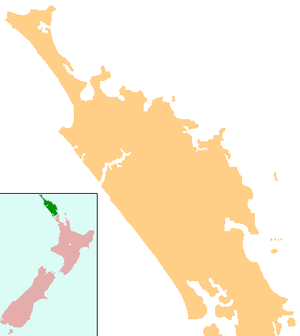
Houhora
Houhora is a locality and harbour on the east side of the Aupouri Peninsula of Northland, New Zealand. It is 41 km (25 mi) north of Kaitaia. Waihopo, Te Raupo, Pukenui, Raio and Houhora Heads are associated localities on the southern shores of the harbour. State Highway 1 passes through all these localities except for Houhora Heads. Te Kao is 24 km north west, and Waiharara is 22 km south east.[1][2]
Houhora | |
|---|---|
 Houhora | |
| Coordinates: 34°47′47″S 173°6′24″E | |
| Country | New Zealand |
| Region | Northland Region |
| District | Far North District |
| Population (2013) | |
| • Total | 930 |

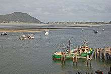
The harbour is long and narrow, mostly sheltered but with exposed sand banks at low tide. There is a deep channel along the southern shore as far as Pukenui Wharf. Mt Camel/Tohoraha (also called Mt Houhora) is a 236-metre hill forming the North Head. The South Head is a flat area.[3]
According to the 2013 New Zealand census, Houhora and its surrounds have a population of 930, an increase of 90 people since the 2006 census.[4]
History
Houhora Mountain was the first part of New Zealand that the early explorer Kupe saw, but he thought it was a whale, according to Māori legend.[5] Houhora was a Māori base settlement in the early 14th century.[6] Snapper, seals, dolphins, moa and other birds were food sources.[7]
James Cook named Mt Camel, on the north head of Houhora Harbour, on 10 December 1769. He described it in his log as "a high mountain or hill standing upon a desert shore."[8]
Te Houtaewa was a Te Aupōuri athlete, who was killed at Pukenui during the Musket Wars of the early 19th century.[9]
Hone Heke was defeated by Tāmati Wāka Nene in the Battle of Te Ahuahu at Pukenui on 12 June 1845.[10]
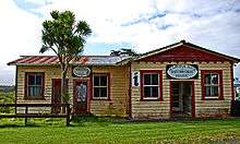
In the 19th century, Houhora Harbour provisioned whalers, and residents mounted their own whaling expeditions in open boats.[8] Three families - Wagener, Subritzky and Yates - settled in the area to farm and trade.[11] The Subritzky family, who arrived near Motueka in 1843, claim to be New Zealand's first Polish settlers. They moved to Australia and then to Houhora Heads.[12] Their homestead there took two years to build in the 1860s. It was sold to a member of the Wagener family in 1897.[8] The homestead, now largely restored, is open to the public.[13] The Wagener Museum at Houhora Heads, built by W E Wagener,[8] was built near the homestead. It contained an eclectic collection of artefacts, but closed in 2003 and a substantial part of the collection was sold off.[14]
A lifeboat from SS Elingamite, which was wrecked on the Three Kings Islands on 9 November 1902, arrived in Houhora the following day with 52 survivors. One of the whalers immediately was dispatched to intercept any vessel along the coast to divert it to the Three Kings. This mission was successful.[8]
Education
Pukenui School is a coeducational full primary (years 1-8) school[15] with a roll of 69 students as of March 2020.[16]
Notable people
- Lloyd Allan Trigg, a pilot in the RNZAF during World War II, and Victoria Cross recipient.
Notes
- Peter Dowling (editor) (2004). Reed New Zealand Atlas. Reed Books. pp. map 2. ISBN 0-7900-0952-8.CS1 maint: extra text: authors list (link)
- Roger Smith, GeographX (2005). The Geographic Atlas of New Zealand. Robbie Burton. pp. map 16. ISBN 1-877333-20-4.
- Parkes, W. F. (c. 1965). The Visitors' Guide to the Far North - Mangonui County (3rd ed.). p. 34.
- 2013 Census QuickStats about a place : Houhora
- "Coastal explorers". Te Ara: The Encyclopedia of New Zealand.
- Michael King (2003). The Penguin History of New Zealand (7th ed.). p. 67. ISBN 0-14-301867-1.
- Louise Furey (2002). Houhora : a fourteenth century Maori village in Northland. ISBN 0908623526. Quoted in The Penguin History of New Zealand
- Parkes, W. F. (c. 1965). The Visitors' Guide to the Far North - Mangonui County (3rd ed.). p. 35.
- "Muriwhenua Tribes - Ancestors Peninsula". Te Ara: The Encyclopedia of New Zealand.
- "HEKE POKAI, Hone". Encyclopedia of New Zealand.
- "Aupōuri Peninsula". Te Ara: The Encyclopedia of New Zealand.
- "Poles - The first arrivals". Te Ara: The Encyclopedia of New Zealand.
- Laura Harper; Tony Mudd; Paul Whitfield (2002). The Rough Guide to New Zealand 3. Rough Guides. p. 217. ISBN 978-1-85828-896-3.
- "New Zealand Archaeology News". New Zealand Archaeological Association. 22 October 2003.
- Education Counts: Pukenui School
- "New Zealand Schools Directory". New Zealand Ministry of Education. Retrieved 26 April 2020.
External links
![]()