Waiharara
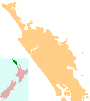
Waiharara is a community at the base of the Aupouri Peninsula in Northland, New Zealand. State Highway 1 runs through the community. To the west is Aupouri Forest, and beyond that Ninety Mile Beach. To the east is Rangaunu Harbour. Houhora is 22 km north west, and Awanui is 16 km south east.[1][2] Lake Waiparera, 35 metres (115 feet) above sea level, is immediately to the north west.[3]
Waiharara | |
|---|---|
 Waiharara | |
| Coordinates: 34°57′11″S 173°11′18″E | |
| Country | New Zealand |
| Region | Northland Region |
| District | Far North District |
The local Kaimaumau Marae is a tribal meeting ground of Ngāi Takoto.[4][5]
Education
Waiharara School is a coeducational full primary (years 1-8) school with a decile rating of 3 and a roll of 27.[6] The school opened in 1901, and moved to its present site in 1949.[7]
Notes
- Peter Dowling (editor) (2004). Reed New Zealand Atlas. Reed Books. pp. map 3. ISBN 0-7900-0952-8.CS1 maint: extra text: authors list (link)
- Roger Smith, GeographX (2005). The Geographic Atlas of New Zealand. Robbie Burton. pp. map 16. ISBN 1-877333-20-4.
- "Ninety Mile Beach". Encyclopedia of New Zealand (1966).
- "Te Kāhui Māngai directory". tkm.govt.nz. Te Puni Kōkiri.
- "Māori Maps". maorimaps.com. Te Potiki National Trust.
- "Te Kete Ipurangi - Waiharara School". Ministry of Education.
- "Time Line". Myrasplace Family History Centre.
This article is issued from Wikipedia. The text is licensed under Creative Commons - Attribution - Sharealike. Additional terms may apply for the media files.