Hotin County
Hotin County was a county (ținut is Middle Ages and Early Modern Period, județ after) in the Principality of Moldavia (1359-1812), the Governorate of Bessarabia (1812–1917), the Moldavian Democratic Republic (1917–1918), and the Kingdom of Romania (1918–1940, 1941-1944).
Județul Hotin | |
|---|---|
County (Județ) | |
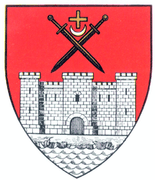 Coat of arms | |
 | |
| Country | |
| Historic region | Bessarabia |
| Capital city (Reședință de județ) | Hotin |
| Established | 1925 |
| Ceased to exist | Administrative and Constitutional Reform in 1938 |
| Area | |
| • Total | 3,782 km2 (1,460 sq mi) |
| Population (1930) | |
| • Total | 395,345 |
| • Density | 100/km2 (270/sq mi) |
| Time zone | UTC+2 (EET) |
| • Summer (DST) | UTC+3 (EEST) |
Its capital was in the city of Hotin (today Khotyn). The territory of the county is currently divided between Ukraine (northern half) and Moldova (southern half).
Geography
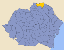
Between the two world wars, Hotin County covered 3,782 km2 and was located in the northeastern part of Greater Romania, being the northernmost County of Bessarabia. It was located on the border with the Soviet Union. In the interwar period, its borders were as follows: the Vinnytsia Oblast in the Ukrainian SSR of the Soviet Union to the north and north-east, the Stanislawow Voivodship of Poland to the north-west, Soroca County to the south-east, Bălți County to south, Dorohoi County to the south and south-west, and Cernăuți County to the west.
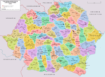
Administrative organization
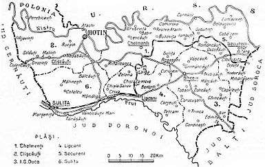
Administratively, Hotin County was divided administratively into the city of Hotin and four (later six) districts (plăşi, singular plasă):[1]
- Plasa Briceni
- Plasa Hotin
- Plasa Lipcani
- Plasa Secureni
Subsequently, two more districts were created:
- Plasa Sulița
- Plasa I.G. Duca
At the autumn 1941 census, the county was administrative divided as follows:
- city of Hotin
- city of Sulița
- Plasa Cetatea Hotinului (or Clișcăuți), headquartered at Clișcăuți
- Plasa Chelmenți (or Vadul lui Traian), headquartered at Chelmenți
- Plasa Briceni, headquartered at Briceni
- Plasa Lipcani, headquartered at Lipcani
- Plasa Secureni, headquartered at Secureni
- Plasa Sulița (or B.P. Hașdeu), headquartered at Sulița
Population
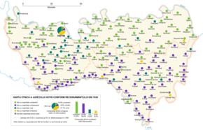
According to the Romanian census of 1930 the population of Hotin County was 392,430, of which 41.6% were ethnic Ukrainians, 35.0% ethnic Romanians, 13.6% ethnic Russians, 9.2% Jews, 0.3% ethnic Poles. Classified by mother tongue: 45.1% spoke Ukrainian, 33.4% spoke Romanian, 12.0% spoke Russian, 9.2% spoke Yiddish. Classified by religion: 87.0% were Orthodox Christian, 9.2% Jewish, 1.9% Baptist, 1.0% Old Believers, and 0.3% Roman Catholic.
According to Russian census of 1897, Ukrainians (Little Russians) represented the majority of population of Khotin Uyezd. There were 160,000 Ukrainians (55%) in rural areas, or 164,000 (53%) including urban areas.[2]
Urban population
In 1930 the urban population of Hotin County was 15,334, which included 37.7% Jews, 36.6% Russians, 14.8% Ukrainians, 8.8% Romanians, and 1.5% Poles by ethnicity. The major mother tongues among the urban population were: Yiddish (37.6%), Russian (37.5%), Ukrainian (14.7%), Romanian (8.6%), and Polish (1.2%) The religious mix of the urban population was 57.6% Eastern Orthodox, 37.7% Jewish, 2.1% Old Believers, and 1.6% Roman Catholic.
History
After the Union of Bessarabia with Romania in 1918, the county was part of Romania, which set up the county formally in 1925.
After the 1938 Administrative and Constitutional Reform, this county merged with the counties of Lăpușna, Orhei and Tighina to form Ținutul Nistru.
The area county of the county was occupied by the Soviet Union in 1940 and became part of the Moldavian SSR and the Ukrainian SSR. The area returned to Romanian administration following the Axis Powers' invasion of the Soviet Union in July 1941. A military administration was established and the region's Jewish population was either executed on the spot or deported to Transnistria, where further numbers were killed.[3] As the Soviet Union's offensive pushed the Axis powers back, the area again was under Soviet control. On September 12, 1944, Romania signed the Moscow Armistice with the Allies. The Armistice, as well as the subsequent peace treaty of 1947, confirmed the Soviet-Romanian border as it was on January 1, 1941.[4][5] The areas of the county, along with the rest of the Moldavian SSR and the Ukrainian SSR, became part of the independent countries of Moldova and Ukraine, respectively.
References
- Portretul României Interbelice - Județul Hotin
- История Румынии и Молдовы: Бессарабия в составе Российской империи Берг Л.С. Бессарабия: страна, люди, хозяйство Archived 2012-07-07 at Archive.today
- James Stuart Olson; Lee Brigance Pappas; Nicholas Charles Pappas (1994). An Ethnohistorical dictionary of the Russian and Soviet empires. Greenwood Publishing Group. p. 484. ISBN 9780313274978.
- "The Avalon Project : The Armistice Agreement with Rumania; September 12, 1944". avalon.law.yale.edu. Retrieved 17 March 2018.
- United States Department of State. Foreign relations of the United States, 1946. Paris Peace Conference: documents Volume IV (1946)
External links
| Wikimedia Commons has media related to Interwar Hotin County. |