Horribilis Peak
Horribilis Peak is 2,597-metre (8,520-foot) mountain summit located in the Coast Mountains of the Pacific Ranges in British Columbia, Canada. The mountain is situated 5.5 km (3.4 mi) north of Talchako Mountain, and 28 km (17 mi) south of Stuie. Its nearest higher peak is Utan Peak, 4 km (2.5 mi) to the northwest.[3] The peak was named in 1964 by a George Whitemore mountaineering party in recognition of the grizzly bears upon whose territory the mountaineers were trespassing.[4] The mountain's name was officially adopted April 15, 1984, by the Geographical Names Board of Canada.[2] Precipitation runoff from the mountain drains into Ape Creek which is a tributary of the Talchako River.
| Horribilis Peak | |
|---|---|
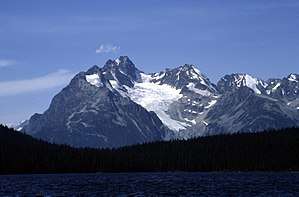 Horribilis Peak from Kidney Lake | |
| Highest point | |
| Elevation | 2,597 m (8,520 ft) [1] |
| Coordinates | 52°08′19″N 126°02′10″W [2] |
| Geography | |
 Horribilis Peak Location in British Columbia  Horribilis Peak Horribilis Peak (Canada) | |
| Location | Range 3 Coast Land District British Columbia, Canada |
| Parent range | Pacific Ranges Coast Mountains |
| Topo map | NTS 93D/01 |
| Climbing | |
| First ascent | 1964 |
Climate
Based on the Köppen climate classification, Horribilis Peak is located in the marine west coast climate zone of western North America.[5] Most weather fronts originate in the Pacific Ocean, and travel east toward the Coast Mountains where they are forced upward by the range (Orographic lift), causing them to drop their moisture in the form of rain or snowfall. As a result, the Coast Mountains experience high precipitation, especially during the winter months in the form of snowfall. Temperatures can drop below −20 °C with wind chill factors below −30 °C.
References
- Horribilis Peak, summitsearch.org
- "Horribilis Peak". Geographical Names Data Base. Natural Resources Canada. Retrieved 2019-12-18.
- Horribilis Peak, summitsearch.org
- "Horribilis Peak". BC Geographical Names.
- Peel, M. C.; Finlayson, B. L. & McMahon, T. A. (2007). "Updated world map of the Köppen−Geiger climate classification". Hydrol. Earth Syst. Sci. 11. ISSN 1027-5606.
External links
- Weather: Horribilis Peak