Blackcomb Peak
Blackcomb Peak is a mountain located east of Whistler, British Columbia that forms the boundary between the Whistler Blackcomb ski resort and Garibaldi Provincial Park. Like Whistler Mountain, it is located on the edge of Garibaldi Provincial Park and the ski lifts are often used to access the park, particularly for the Spearhead Traverse.
- This article describes the geographical feature Blackcomb Peak, for the ski resort see Whistler Blackcomb.
| Blackcomb Peak | |
|---|---|
 | |
| Highest point | |
| Elevation | 2,436 m (7,992 ft) [1] |
| Prominence | 86 m (282 ft) [1] |
| Coordinates | 50°04′53″N 122°52′15″W [1] |
| Geography | |
 Blackcomb Peak Location in British Columbia  Blackcomb Peak Blackcomb Peak (Canada) | |
| Location | British Columbia, Canada |
| Parent range | Fitzsimmons Range |
| Topo map | NTC 92J/02 |
| Climbing | |
| First ascent | 1923 Phyllis Munday, Don Munday[1] |
| Easiest route | class 3 |
Several skiing runs are established on the mountain, with Whistler Village at the base of the mountain on the side facing Whistler Mountain, and Blackcomb Village on the face opposite. The 2010 Winter Olympics sliding sports took place on its slopes, with the Whistler Sliding Centre located on it.
Climate
Based on the Köppen climate classification, Blackcomb Peak is located in the marine west coast climate zone of western North America.[2]

Most weather fronts originate in the Pacific Ocean, and travel east toward the Coast Mountains where they are forced upward by the range (Orographic lift), causing them to drop their moisture in the form of rain or snowfall. As a result, the Coast Mountains experience high precipitation, especially during the winter months in the form of snowfall. Temperatures can drop below −20 °C with wind chill factors below −30 °C. The months July through September offer the most favorable weather for climbing Blackcomb Peak.
Gallery
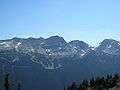 Blackcomb, with the 7th Heaven ski run, after the ski season
 Blackcomb in 2007, ski run featured
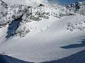 View of Blackcomb Glacier from the "Blowhole" entrance to Blackcomb Glacier Provincial Park. Spearhead Mtn in foreground, Phalanx Mtn on left

References
- "Blackcomb Peak". Bivouac.com. Retrieved 2007-02-18.
- Peel, M. C.; Finlayson, B. L. & McMahon, T. A. (2007). "Updated world map of the Köppen−Geiger climate classification". Hydrol. Earth Syst. Sci. 11. ISSN 1027-5606.