Horní Radslavice
Horní Radslavice is a village and municipality (obec) in Žďár nad Sázavou District in the Vysočina Region of the Czech Republic.
Horní Radslavice | |
|---|---|
Municipality | |
 | |
 Horní Radslavice | |
| Coordinates: 49°20′21″N 15°53′36″E | |
| Country | |
| Region | Vysočina |
| District | Žďár nad Sázavou |
| Area | |
| • Total | 4.67 km2 (1.80 sq mi) |
| Elevation | 514 m (1,686 ft) |
| Population (2006) | |
| • Total | 95 |
| • Density | 20/km2 (53/sq mi) |
| Postal code | 594 01 |
| Website | http://www.horniradslavice.cz |
The municipality covers an area of 4.67 square kilometres (1.80 sq mi), and has a population of 95 (as at 2 October 2006).
Horní Radslavice lies approximately 26 kilometres (16 mi) south of Žďár nad Sázavou, 23 km (14 mi) east of Jihlava, and 135 km (84 mi) south-east of Prague.
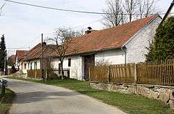
Gallery
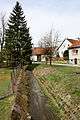 Local brook
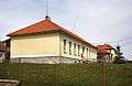 Municipal office
 Main street
This article is issued from Wikipedia. The text is licensed under Creative Commons - Attribution - Sharealike. Additional terms may apply for the media files.