Hoeksche Waard
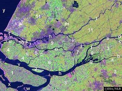
The Hoekse Waard (Dutch pronunciation: [ˈɦuksə ˈʋaːrt]; pre-1947 spelling: Hoeksche Waard) is an island between the Oude Maas, Dordtsche Kil, Hollands Diep, Haringvliet and Spui rivers in the province of South Holland in the Netherlands. The island, part of the namesake municipality of Hoeksche Waard, is a mostly agricultural region, south of the outskirts of Rotterdam. The Hoeksche Waard consists of reclaimed land (polders): after the Saint Elisabeth flood of 1421 most of the area was flooded. The land has been reclaimed gradually in the following centuries.[1]
Former municipalities
The Hoeksche Waard formerly consisted of the following municipalities until these were merged on January 1, 2019:
- Binnenmaas (villages Blaaksedijk, Heinenoord, Goidschalxoord, Maasdam, Mijnsheerenland, Puttershoek, Westmaas and 's-Gravendeel)
- Cromstrijen (villages Klaaswaal and Numansdorp)
- Korendijk (villages Goudswaard, Nieuw-Beijerland, Piershil and Zuid-Beijerland)
- Oud-Beijerland
- Strijen (villages Cillaarshoek, Mookhoek, Strijen and Strijensas)
Surrounding waters
The Hoeksche Waard is separated:
- from IJsselmonde island on the north by the Oude Maas (tunnel)
- from Voorne-Putten island on the west by the Spui (ferry)
- from the island of Dordrecht on the east by the Dordtsche Kil (tunnel)
- from Goeree-Overflakkee island on the southwest by the Haringvliet (bridge)
- from the Province of North Brabant on the southeast by the Hollands Diep (bridge)
References
- Karel Leenders (1999). "Geschiedenis van de Hoeksche Waard" (in Dutch).
This article is issued from Wikipedia. The text is licensed under Creative Commons - Attribution - Sharealike. Additional terms may apply for the media files.