Hochon County
Hŏch'ŏn County is a county in South Hamgyŏng province, North Korea. It was created after the division of Korea, from portions of Tanch'ŏn and P'ungsan.
Hochon County 허천군 | |
|---|---|
| Korean transcription(s) | |
| • Hanja | 虛川郡 |
| • McCune-Reischauer | Hŏch'ŏn kun |
| • Revised Romanization | Heocheon-gun |
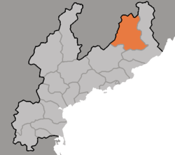 Map of South Hamgyong showing the location of Hochon | |
| Coordinates: 40°45′57″N 128°33′15″E | |
| Country | North Korea |
| Province | South Hamgyong Province |
| Administrative divisions | 1 ŭp, 5 workers' districts, 17 ri |
| Area | |
| • Total | 1,684 km2 (650 sq mi) |
| Population (1991 est.) | |
| • Total | 100,000 |
Geography
Most of the county is steep and mountainous, particularly in the southeast. There are numerous high peaks. The Pujŏllyŏng and Kŏmdŏk Mountains (검덕산맥) pass through the county, with the highest peak at Kŏmdŏksan.
The chief stream is the Namdaech'ŏn. Approximately 90% of the county is forestland.
Administrative divisions
Hŏch'ŏn county is divided into 1 ŭp (town), 5 rodongjagu (workers' districts) and 17 ri (villages):
|
|
Economy
Mining and electrical power are the chief local industries. There are deposits of copper, iron ore, lead, and zinc. Local crops include maize, soybeans, and potatoes, but cultivation is difficult due to the mountainous terrain.
Transportation
Hŏch'ŏn county is served by the Hŏch'ŏn and Mandŏk lines of the Korean State Railway, and by various roads.
See also
- Geography of North Korea
- Administrative divisions of North Korea
- South Hamgyong
External links
- (in Korean) In Korean language online encyclopedias: