Hesket, Cumbria
Hesket, also known as Hesket-in-the-Forest, is a large civil parish in the Eden District of Cumbria, England, situated along the A6 between Carlisle and Penrith. It was formed in 1894 with the passing of the Local Government Act 1894 and extended to incorporate the former parish of Plumpton Wall by a County Review Order in 1934. Part of the historic royal hunting ground of Inglewood Forest, settlement in the area dates back to the Roman occupation.
| Hesket | |
|---|---|
 View over Barrock Fell, in Hesket Parish | |
 Hesket Location within Cumbria | |
| Population | 2,588 (2011)[1] |
| OS grid reference | NY4744 |
| Civil parish |
|
| District |
|
| Shire county | |
| Region | |
| Country | England |
| Sovereign state | United Kingdom |
| Post town | CARLISLE |
| Postcode district | CA4 |
| Dialling code | 01697 |
| Police | Cumbria |
| Fire | Cumbria |
| Ambulance | North West |
| UK Parliament |
|
Extent
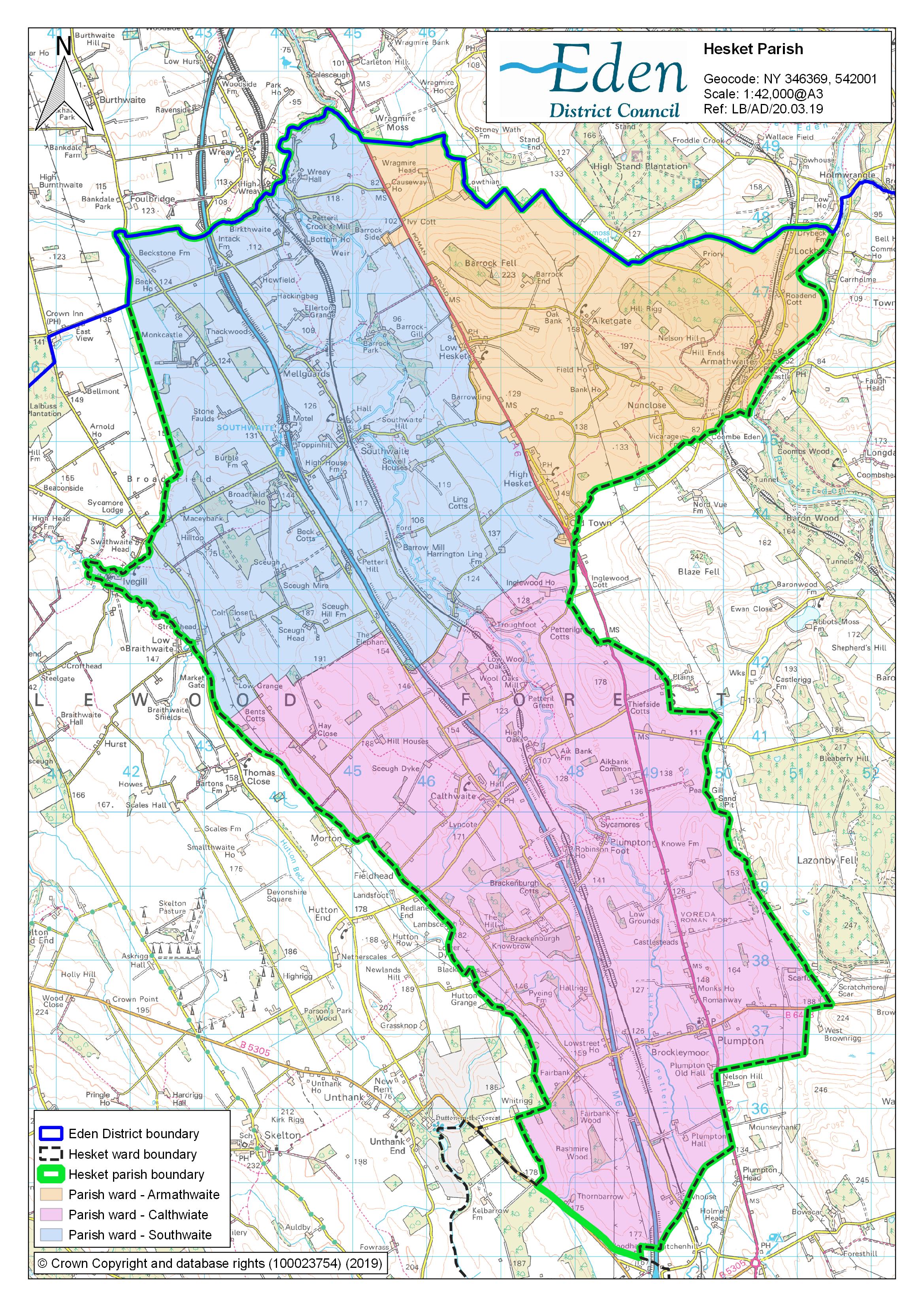
The parish is located between the city of Carlisle and the market town of Penrith, along nine miles of the A6.[2] The parish encompasses the villages of Armathwaite, Calthwaite, High Hesket, Low Hesket, Plumpton and Southwaite, as well as the hamlets of Aiketgate, Morton, Old Town, Thiefside, Petteril Green and Plumpton Foot. It also includes parts of the villages of Ivegill and Wreay, with these villages also part of the parishes of Skelton and St Cuthbert Without respectively.[3] At the 2011 census, the parish population stood at 2,588.[1]
History
At Castlesteads or Old Penrith just north of Plumpton village are the remains of a Roman Fort known as Voreda.[4] Just north of the site, aerial evidence has located two Roman camps, with limited excavation work in 1977 revealing pottery dating from AD 120.[5][6] The structures are located near to the main Roman Road connecting the Vale of York to Carlilse, which now forms part of the modern-day A6.[6]
Many of the villages in the parish have names with Norse origins, often with the common suffix of 'thwaite', from the Norse clearing or meadow. The name Hesket itself derives from the old Norse for horse ('hestr') and road or race course ('skeid').[7] In 1822, a viking cairn was discovered in the parish, along the route of the A6, near to the modern day location of Court Thorn GP Surgery, during operations to widen the road. The objects uncovered were incorporated into the collection at Tuille House Museum in Carlisle.[8]
The Parish is part of the Royal hunting ground known as Inglewood Forest, established by William the Conqueror and extended by Henry II.[9]
In 1885, Police Constable Joseph Byrnes was shot and killed by three assailants in Plumpton. The trio were wanted in connection with a burglary at Netherby Hall. The men were later caught, and sentenced to death by hanging.[10] A memorial to Constable Byrnes was erected in the village, which is now Grade II listed.[11]
The civil parishes of Hesket-in-the-Forest and Plumpton Wall were formed with the passing of the Local Government Act 1894. Plumpton Wall was later incorporated into Hesket-in-the-Forest, following a County Review Order in 1934.[12]
Governance
Hesket is in the United Kingdom parliamentary constituency of Penrith and the Border.[13] Neil Hudson was elected its Conservative Member of Parliament at the 2019 General Election,[14] replacing fellow Conservative Rory Stewart, who announced his intention to stand down from both parliament and the party in October 2019.[15]
A district ward named Hesket exists, which incorporates the Parishes of Hesket and Catterlen, electing two representatives to Eden District Council.[16] The ward is currently represented by Conservative Councilor Elaine Martin and Independent Group Councillor David Ryland, both elected in May 2019.[17] At county level, the parish falls within the Greystoke and Hesket ward, electing one County Councillor onto Cumbria County Council. In 2017, the seat was won by Conservative Councillor Tom Wentworth-Waites.[18]
Hesket Parish Council is divided into three electoral wards, Armathwaite, Calthwaite and Southwaite, each electing five Parish Councillors.[19]
Transport
The historic Settle-Carlisle Railway, which opened in 1876, runs through the parish with a station at Armathwaite.[20] Adjacent to the station is a Victorian signal box, restored and maintained by local volunteers and open to the public for viewing.[21] The West Coast Main Line also runs through the parish.[22] At one time there were stations on this line at Plumpton, which closed in 1948,[23] and at Southwaite and Calthwaite, both of which closed in 1952.[24][25] The M6 motorway and the A6 road run parallel to each other through the parish with a motorway service area at Southwaite.[26] The 104 bus service also runs through the villages of Plumpton, Low Hesket and High Hesket, operated by Stagecoach, running between Carlisle and Penrith.[27][28] There is also a community bus service, Fellrunner, which provides return journeys to Carlisle and Penrith from various locations within the Parish.[29]
Places of interest
The parish is home to sixty-six listed buildings including three Grade II* listed buildings: Armathwaite Castle,[30] now a private residence; the Church of St Mary's in High Hesket,[31] dating from the eighteenth century but also incorporating parts of the original medieval church building; and the sixteenth century Southwaite Hall Copper House and barns.[32] It is also home to the Grade II listed Katharine Well, situated at Mellguards just outside the village of Southwaite. The well was built as a memorial to the sister of local architect and philanthropist Sarah Losh.[33]
Gallery
 The Old School Hall, Armathwaite, now a village hall
 All Saints Church, Calthwaite
 High Hesket Church of England Primary School
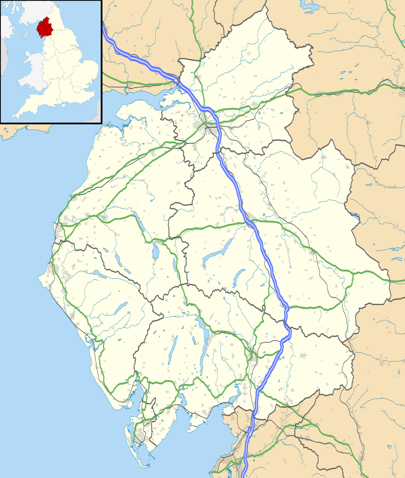
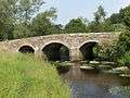 Crook's Bridge, over the River Petteril
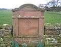 Byrnes Monument, Plumpton
 Railway Bridge, Southwaite
 Traditional Cumberland signpost
External links
References
- "Parish population 2011". Retrieved 21 June 2015.
- "Local Area". Hesket Parish Council. Retrieved 16 February 2020.
- "Parish Map". Hesket Parish Council. Retrieved 16 February 2020.
- Historic England, "Old Penrtih (Voreda) Plumpton Wall (1007190)", National Heritage List for England, retrieved 30 May 2019
- Historic England, "Roman camp 200m west of Galleygill Bridge (1007869)", National Heritage List for England, retrieved 27 February 2020
- Historic England, "Roman camp 200m south west of Knowe Farm (1007870)", National Heritage List for England, retrieved 27 February 2020
- Sedgefield, Walter John (1915). The Place Names of Cumberland and Westmorland. Manchester University Press. ISBN 978-1332027576.
- Cowen, J.D (1934). "A catalogue of objects of the Viking period in the Tuille House Museum, Carlisle" (PDF). Cumberland and Westmorland Antiquarian and Archaeological Society Transactions. 2. 34: 174–180. Retrieved 16 February 2020.
- Hesket Local History Group (2000). The Civil Parish of Hesket in the Forest:An Illustrated Miscellany. Hesket in the Forest Parish Council.
- "Memorial to be unveiled for policeman murdered in 1885". Cumberland and Westmorland Herald. 21 October 2006. Retrieved 16 February 2020.
- Historic England, "Byrnes Monument, Hesket (1145475)", National Heritage List for England, retrieved 13 October 2016
- "Welcome to Hesket Parish". Hesket Parish Council. Retrieved 16 February 2020.
- "Westminster Parliamentary Constituencies". Office of National Statistics. 3 November 2019. Retrieved 16 February 2020.
- "Penrith and the Border Results". BBC News. Archived from the original on 16 February 2020. Retrieved 16 February 2020.
- Proctor, Kate; Walker, Peter (4 October 2019). "Rory Stewart quits Conservatives to run for London mayoralty". The Guardian. Retrieved 16 February 2020.
- "The District of Eden (Electoral Changes) Order 1998", legislation.gov.uk, The National Archives, 16 October 1998, SI 1998/2547
- "District election 2019 results". Eden District Council. Retrieved 16 February 2020.
- "Division result, Greystoke and Hesket". Cumbria County Council. Retrieved 16 February 2020.
- "Parish Overview". Hesket Parish Council. Retrieved 16 February 2020.
- Salveson. Paul (2019). TheSettle-Carlisle Railway. The Crowood Press. ISBN 978-1-78500-637-1.
- "Restoration of Victorian signal box "labour of love" for volunteers". Cumberland and Westmorland Herald. 13 January 2017. Retrieved 30 May 2019.
- "The West Coast Main Line Railway in Cumbria". Visit Cumbria. Retrieved 16 February 2020.
- Butt, R.V.J. (1995). The Directory Of Railway Stations. Patrick Stephens Limited. p. 186. ISBN 978-1-85260-508-7.
- Butt, R.V.J. (1995). The Directory Of Railway Stations. Patrick Stephens Limited. p. 217. ISBN 978-1-85260-508-7.
- Butt, R.V.J. (1995). The Directory Of Railway Stations. Patrick Stephens Limited. p. 51. ISBN 978-1-85260-508-7.
- "M6. Carlisle By-pass & Penrith to Carlisle (J41 to J44) and extension to the Scottish border". The Motorway Archive. Retrieved 16 February 2020.
- "Carlisle Area" (PDF). Cumbria County Council. Retrieved 16 February 2020.
- "Penrith Area" (PDF). Cumbria County Council. Retrieved 16 February 2020.
- "Timetable". Fellrunner. Retrieved 27 February 2020.
- Historic England, "Armathwaite Castle, Hesket (1145496)", National Heritage List for England, retrieved 30 May 2019
- Historic England, "Church of St Mary, Hesket (1326696)", National Heritage List for England, retrieved 30 May 2019
- Historic England, "Southwaite Hall, Copper House and barns adjoining, Hesket (1210645)", National Heritage List for England, retrieved 30 May 2019
- Historic England, "Katharine Well, Hesket (1145480)", National Heritage List for England, retrieved 30 May 2019
| Wikimedia Commons has media related to Hesket, Cumbria. |
Cumbria Portal | |
| Boroughs or districts | |
| Major settlements |
|
| Topics | |