Heroldsberg
Heroldsberg is a municipality in the district of Erlangen-Höchstadt, in Bavaria, Germany. It is located eleven kilometers north-east from the city of Nuremberg and 23 kilometers east from Erlangen and is the headquarters of Schwan-Stabilo.
Heroldsberg | |
|---|---|
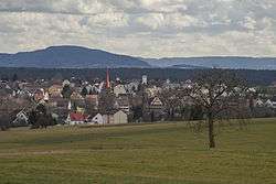 Heroldsberg seen from the west | |
 Coat of arms | |
Location of Heroldsberg within Erlangen-Höchstadt district 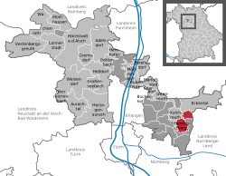 | |
 Heroldsberg  Heroldsberg | |
| Coordinates: 49°32′N 11°9′E | |
| Country | Germany |
| State | Bavaria |
| Admin. region | Mittelfranken |
| District | Erlangen-Höchstadt |
| Government | |
| • Mayor | Johannes Schalwig (CSU) |
| Area | |
| • Total | 11.02 km2 (4.25 sq mi) |
| Highest elevation | 378 m (1,240 ft) |
| Lowest elevation | 335 m (1,099 ft) |
| Population (2018-12-31)[1] | |
| • Total | 8,472 |
| • Density | 770/km2 (2,000/sq mi) |
| Time zone | CET/CEST (UTC+1/+2) |
| Postal codes | 90562 |
| Dialling codes | 0911 09126 (Groß- and Kleingeschaidt) |
| Vehicle registration | ERH |
| Website | www.heroldsberg.de |
Geography
Location
It is in the Sebalder Reichswald, the forest north to Nuremberg and is on a ridge. The Gründlach, a side river of the Regnitz, flows through the village of Heroldsberg.
Municipality
It contains Großgeschaidt, Kleingeschaidt and the villages of Heroldsberg, consisting of Heroldsberg, Johannisthal and Hundsmühle.[2]
Surrounding Municipalities
It is surrounded by Eckental, Lauf an der Pegnitz, Nuremberg and Kalchreuth.
History
Heroldsberg's history goes back to the 11th hundreds in which it was founded as an administrative base for the German emperor. Later on in 1391 the territory was sold to the patrician family Geuder in whose possession it was for over 400 years. It was them who built the four manors and the fortified church at the village's market square.
Famous painter Albrecht Dürer made the first graphical depiction of Heroldsberg in 1510. It shows the old village center.
From the 15th to the 17th century there were times of growth and upswing yet diminished by destruction for example through the Margrave Wars and the Thirty Years' War. In 1796 the Geuder family lost the fiefdom and the territory became Prussian, though in the Napoleonic Wars it was under French administration for four years. Ever since 1810 Heroldsberg belongs to Bavaria.
After World War II around 1,700 Heimatvertriebene, ethnic Germans who were forced to leave their eastern-European homecountries after the second World War, settled in Heroldsberg. Since the Bavarian territorial reform in 1978 the villages of Großgeschaidt and Kleingeschaidt are part of the community.[3][4]
Coat of arms
The coat of arms of Heroldsberg shows a golden lion's head, surrounded by three silver stars on a blue background. It was given to the village by King Sigmund in 1417 at the request of Kunz Geuder.[3]
References
- "Fortschreibung des Bevölkerungsstandes". Bayerisches Landesamt für Statistik und Datenverarbeitung (in German). July 2019.
- © Bayerisches Landesamt für Statistik, Fürth 2016 (2019-05-10). "Bavarian State Office for Statistics - GENESIS-Online". www.statistikdaten.bayern.de. Retrieved 2019-05-10.
- http://www.heroldsberg.de/start/ortsgeschichte
- "Archived copy" (PDF). Archived from the original (PDF) on 2013-12-02. Retrieved 2014-02-13.CS1 maint: archived copy as title (link)
Places adjacent to Heroldsberg | |
|---|---|
Towns and municipalities in Erlangen-Höchstadt | ||
|---|---|---|
Coat of Arms of Erlangen-Höchstadt district | ||
| Authority control |
|
|---|