Hateruma
Hateruma (波照間島; Hateruma-jima; Yaeyama: Patirooma, Hateruma dialect: Besїma "our island", Okinawan: Hatiruma) is an island in the Yaeyama District of Okinawa Prefecture, Japan.[1] Part of the town Taketomi, it is the southern-most inhabited island in Japan at 24°2’25" north latitude, 123°47’16" east longitude. Hateruma is one of the Yaeyama Islands, and is located 24 kilometres (15 mi) south of Iriomote-jima, the largest of the island group.[2]
| Native name: | |
|---|---|
 Aerial view of Hateruma | |
 Hateruma 波照間島 | |
| Geography | |
| Archipelago | Yaeyama Islands |
| Adjacent bodies of water | Pacific Ocean |
| Area | 12.7 km2 (4.9 sq mi) |
| Coastline | 14.8 km (9.2 mi) |
| Highest elevation | 59.5 m (195.2 ft) |
| Administration | |
| Prefectures | Okinawa Prefecture |
| District | Yaeyama |
| Town | Taketomi |
Hateruma, which is composed of corals, has 12.7 km² of area and approximately 600 inhabitants.
The primary products of the island include sugarcane, pineapple, refined sugar, and Awanami, a highly prized type of the alcoholic beverage awamori.[1] Its southern location makes it one of the few places in Japan where the Southern Cross can be observed.
Sights
Hateruma is visited by a comparatively high number of Japanese tourists from Ishigaki on day trips, as it boasts the southernmost tip of land of Japan. In addition, the southernmost school and the southernmost police station of Japan are tourist attractions. Further places of interest include:
- In the only village several well-preserved old houses showing the traditional architecture with a hip roof, red tiles and a shisa statue on the top can be seen. Many old houses are still surrounded by a thick wall consisting of dark coral stones.
- In the village center there is a memorial to Oyake Akahachi, a rebel who was born on Haterumajima around 1500. The memorial was erected on a platform of coral stones.
- One of the most interesting buildings on Haterumajima is the old watchtower Kodomori dating from the 17th century. It was used for observing the ships sailing to and from Ishigaki. As the top of the tower was one of the highest points of the flat island, it was used for smoke signals and for signal lights. A similar tower, which is called Puzumari, can be visited on the neighboring island Kuroshima.
- On the south coast there is a memorial indicating the southernmost tip of land of Japan. The south coast is steep and the sea is very rough there.
- The north coast of Haterumajima is a favorite tourist destination because of its fine sand.
Climate
Hateruma has a tropical climate as all twelve months there have mean temperatures of at least 18 °C (64 °F).
| Climate data for Hateruma (2000-2012) | |||||||||||||
|---|---|---|---|---|---|---|---|---|---|---|---|---|---|
| Month | Jan | Feb | Mar | Apr | May | Jun | Jul | Aug | Sep | Oct | Nov | Dec | Year |
| Average high °C (°F) | 21 (70) |
22 (72) |
23 (73) |
26 (79) |
28 (82) |
31 (88) |
32 (90) |
32 (90) |
31 (88) |
29 (84) |
26 (79) |
23 (73) |
27 (81) |
| Average low °C (°F) | 16 (61) |
16 (61) |
18 (64) |
21 (70) |
23 (73) |
26 (79) |
27 (81) |
27 (81) |
25 (77) |
23 (73) |
21 (70) |
18 (64) |
22 (71) |
| Average rainfall mm (inches) | 151.3 (5.96) |
127.9 (5.04) |
158 (6.2) |
147.6 (5.81) |
209.8 (8.26) |
244 (9.6) |
118.1 (4.65) |
253.4 (9.98) |
308 (12.1) |
203.7 (8.02) |
150.7 (5.93) |
153.8 (6.06) |
2,226.3 (87.61) |
| Average precipitation days | 25 | 21 | 22 | 20 | 20 | 19 | 18 | 20 | 20 | 22 | 22 | 24 | 253 |
| Source: World Weather Online[3] | |||||||||||||
Infrastructure
Hateruma Airport is located on the island but is not currently served by any commercial flights. Haterujima is easily accessible by ferry from Ishigaki several times a day. There are several guest houses and some shops and restaurants on the island. Bikes are for hire at the harbour.
Gallery
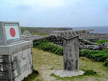 Monument at the southernmost point of Japan open to the public
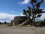 Kodomori Tower
 South Coast
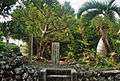 Akahachi Memorial
 Village center
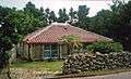 Traditional architecture
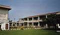 The southernmost school of Japan
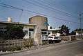 The southernmost police station of Japan
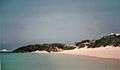 North Coast
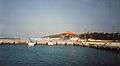 Harbour
See also
- Geography of Japan
- Japanese Archipelago
- List of extreme points of Japan
- Okinotorishima
- Paipatirōma-jima
References
- "波照間島" [Hateruma]. Dijitaru Daijisen (in Japanese). Tokyo: Shogakukan. 2013. OCLC 56431036. Archived from the original on 2007-08-25. Retrieved 2013-01-17.
- "波照間島" [Hateruma]. Nihon Daihyakka Zensho (Nipponika) (in Japanese). Tokyo: Shogakukan. 2013. OCLC 153301537. Archived from the original on 2007-08-25. Retrieved 2013-01-17.
- "Hateruma, Okinawa Monthly Climate Average, Japan". World Weather Online. Retrieved 2017-02-04.
Bibliography
- Yamakei: Ryukyu Nansei Shoto, p. 120-121. Tokio 2003. ISBN 4-635-01718-4
External links
- 美しき島々 ~波照間島~ (Japanese page)
- 美ら島物語 波照間島情報 (Japanese page)
| Wikimedia Commons has media related to Haterumajima. |
| Authority control |
|
|---|