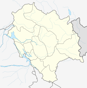
Hamta Pass
Hamta Pass lies at an altitude of 4270 m (14039 ft) on the Pir Panjal range in the Himalayas. It is a small corridor between Lahaul's Chandra Valley and Kullu valley of Himachal Pradesh, India. The nomenclature of the trek was derived from Hamta Village, located below Sethan village, as part of the trek route. This pass is frequently used by shepherds of the lower Himalayan region, seeking high altitude grasslands in the summer, when the dry cold desert of Lahaul is barren.
Hamta Pass | |
|---|---|
Mountain Pass | |
| Nickname(s): Hamta | |
 Hamta Pass  Hamta Pass | |
| Coordinates: 31.963024°N 77.453296°E | |
| Country | India |
| State | Himachal Pradesh |
| District | Kullu |
| Elevation | 4,270 m (14,010 ft) |
| Languages | |
| • Official | Hindi |
| • Regional | Kulvi |
Standard trek itinerary
Day 1 (Manali to Jobri, 19 km, drive 45 mins. Jobri to Chikka, 3–4 hours): Short drive from Manali, passing Prini, Sethan, and Jobra. The road ends at Jobri, and climbers will cross a small river and begin the trek from here. The route goes through mixed forests of pine, maple and birch trees, and eventually runs along the Hamta river. The day's trek ends at Chikka, where there is a waterfall close to the campsite.
Day 2 (Chikka to Balu ka Ghera, 5–6 hours): Today's route is a gradual ascent along the Hamta river to Jwara meadows. There is a shepherds' hut and a tea shop here, so this spot is usually a refreshment or lunch stop. The trek proceeds from here to Balu ka Ghera. This is usually the stop for the night. It's also the spot from where trekkers get their first views of Hamta pass.
Day 3 (Balu Ghera to Shea goru, cross Hamta pass, 7–8 hours): The climb for today starts off as fairly gradual, but can get steep as climbers approach the pass. It will take about 3-4 hrs to reach Hamta Pass. From the pass, climbers will be able to see Indrasan Peak and a few more famous peaks. It is usually windy and cold in the Pass, so most groups don't stay for long. There is a steep descent of about two hours from here into the Lahaul valley. After that, the trail opens up and becomes easier. The campsite at Shea Goru plain is the stop for the night and is considered one of the most scenic campsites on the trek.
Day 4 (Shea Goru to Chhatru, 5 hours): Cold glacial melt stream crossing near Shea goru and further trail descend through boulder of rocks, moraine to the valley floor. Next along the left bank of Chandra River to Chhatru. The trek ends at Chhatru. Many itineraries include a visit to Chandratal lake. Chhatru to Chandratal distance is 46 km. Those looking to visit Spiti valley. There is a bus between Manali - Kaza, which runs every day. All you have to do is find your seat. Chhatru to Kaza distance is 119 km. Those who want to visit Keylong and further travel to Leh. First, need to come to Gramphoo 17 km or further 5 km to Koksar. Numbers of buses run to Keylong from Manali.
Gallery
 Hamta Pass corridor
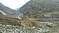 Chhatru Settlement in the Spiti Valley from Shia Goru
 Valley
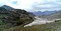 River
River
- Panorama view (3777m)

References
- "The Manali Diaries - Hampta Pass Trek". Retrieved 21 September 2019.
- Lonely Planet
- National Geographic Traveller India
- The Ghumakkads