Gumbetovsky District
Gumbetovsky District (Russian: Гумбе́товский райо́н; Avar: Бакълъул мухъ) is an administrative[1] and municipal[5] district (raion), one of the forty-one in the Republic of Dagestan, Russia. It is located in the west of the republic. The area of the district is 730 square kilometers (280 sq mi). Its administrative center is the rural locality (a selo) of Mekhelta.[1] As of the 2010 Census, the total population of the district was 22,046, with the population of Mekhelta accounting for 15.0% of that number.[2]
Gumbetovsky District Гумбетовский район | |
|---|---|
| Other transcription(s) | |
| • Avar | Бакълъул мухъ |
 Coat of arms | |
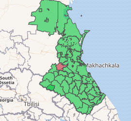
Location of Gumbetovsky District in the Republic of Dagestan | |
| Coordinates: 42°48′N 46°30′E | |
| Country | Russia |
| Federal subject | Republic of Dagestan[1] |
| Established | 1928 |
| Administrative center | Mekhelta[1] |
| Area | |
| • Total | 730 km2 (280 sq mi) |
| Population | |
| • Total | 22,046 |
| • Estimate (2018)[3] | 22,891 (+3.8%) |
| • Density | 30/km2 (78/sq mi) |
| • Urban | 0% |
| • Rural | 100% |
| Administrative structure | |
| • Administrative divisions | 6 Selsoviets |
| • Inhabited localities[4] | 27 Rural localities |
| Municipal structure | |
| • Municipally incorporated as | Gumbetovsky Municipal District[5] |
| • Municipal divisions[5] | 0 Urban settlements, 15 Rural settlements |
| Time zone | UTC+3 (MSK |
| OKTMO ID | 82615000 |
| Website | http://www.mo-gumbet.ru |
| 2010 Census | 22,046[2] |
|---|---|
| 2002 Census | 18,177[7] |
| 1989 Census | 11,317[8] |
| 1979 Census | 13,180[9] |
Administrative and municipal status
Within the framework of administrative divisions, Gumbetovsky District is one of the forty-one in the Republic of Dagestan.[1] The district is divided into six selsoviets which comprise twenty-seven rural localities.[4] As a municipal division, the district is incorporated as Gumbetovsky Municipal District.[5] Its six selsoviets are incorporated as fifteen rural settlements within the municipal district.[5] The selo of Mekhelta serves as the administrative center of both the administrative[1] and municipal[10] district.
References
Notes
- Law #16
- Russian Federal State Statistics Service (2011). "Всероссийская перепись населения 2010 года. Том 1" [2010 All-Russian Population Census, vol. 1]. Всероссийская перепись населения 2010 года [2010 All-Russia Population Census] (in Russian). Federal State Statistics Service.
- "26. Численность постоянного населения Российской Федерации по муниципальным образованиям на 1 января 2018 года". Federal State Statistics Service. Retrieved January 23, 2019.
- Государственный комитет Российской Федерации по статистике. Комитет Российской Федерации по стандартизации, метрологии и сертификации. №ОК 019-95 1 января 1997 г. «Общероссийский классификатор объектов административно-территориального деления. Код 82 215», в ред. изменения №278/2015 от 1 января 2016 г.. (State Statistics Committee of the Russian Federation. Committee of the Russian Federation on Standardization, Metrology, and Certification. #OK 019-95 January 1, 1997 Russian Classification of Objects of Administrative Division (OKATO). Code 82 215, as amended by the Amendment #278/2015 of January 1, 2016. ).
- Law #6
- "Об исчислении времени". Официальный интернет-портал правовой информации (in Russian). June 3, 2011. Retrieved January 19, 2019.
- Russian Federal State Statistics Service (May 21, 2004). "Численность населения России, субъектов Российской Федерации в составе федеральных округов, районов, городских поселений, сельских населённых пунктов – районных центров и сельских населённых пунктов с населением 3 тысячи и более человек" [Population of Russia, Its Federal Districts, Federal Subjects, Districts, Urban Localities, Rural Localities—Administrative Centers, and Rural Localities with Population of Over 3,000] (XLS). Всероссийская перепись населения 2002 года [All-Russia Population Census of 2002] (in Russian).
- "Всесоюзная перепись населения 1989 г. Численность наличного населения союзных и автономных республик, автономных областей и округов, краёв, областей, районов, городских поселений и сёл-райцентров" [All Union Population Census of 1989: Present Population of Union and Autonomous Republics, Autonomous Oblasts and Okrugs, Krais, Oblasts, Districts, Urban Settlements, and Villages Serving as District Administrative Centers]. Всесоюзная перепись населения 1989 года [All-Union Population Census of 1989] (in Russian). Институт демографии Национального исследовательского университета: Высшая школа экономики [Institute of Demography at the National Research University: Higher School of Economics]. 1989 – via Demoscope Weekly.
- "Всесоюзная перепись населения 1979 г. Национальный состав населения по регионам России" [All Union Population Census of 1979. Ethnic composition of the population by regions of Russia] (XLS). Всесоюзная перепись населения 1979 года [All-Union Population Census of 1979] (in Russian). 1979 – via Demoscope Weekly (website of the Institute of Demographics of the State University—Higher School of Economics.
- Федеральная служба государственной статистики. Федеральное агентство по технологическому регулированию и метрологии. №ОК 033-2013 1 января 2014 г. «Общероссийский классификатор территорий муниципальных образований. Код 82 615». (Federal State Statistics Service. Federal Agency on Technological Regulation and Metrology. #OK 033-2013 January 1, 2014 Russian Classification of Territories of Municipal Formations. Code 82 615. ).
Sources
- Народное Собрание Республики Дагестан. Закон №16 от 10 апреля 2002 г. «Об административно-территориальном устройстве Республики Дагестан», в ред. Закона №106 от 30 декабря 2013 г. «О внесении изменений в некоторые законодательные акты Республики Дагестан». Вступил в силу со дня официального опубликования. Опубликован: "Дагестанская правда", №81, 12 апреля 2002 г. (People's Assembly of the Republic of Dagestan. Law #16 of April 10, 2002 On the Administrative-Territorial Structure of the Republic of Dagestan, as amended by the Law #106 of December 30, 2013 On Amending Various Legislative Acts of the Republic of Dagestan. Effective as of the day of the official publication.).
- Народное Собрание Республики Дагестан. Закон №6 от 13 января 2005 г. «О статусе и границах муниципальных образований Республики Дагестан», в ред. Закона №43 от 30 апреля 2015 г. «О статусе городского округа с внутригородским делением "Город Махачкала", статусе и границах внутригородских районов в составе городского округа с внутригородским делением "Город Махачкала" и о внесении изменений в отдельные законодательные акты Республики Дагестан». Вступил в силу со дня официального опубликования. Опубликован: "Дагестанская правда", №8, 15 февраля 2005 г. (People's Assembly of the Republic of Dagestan. Law #6 of January 13, 2005 On the Status and Borders of the Municipal Formations of the Republic of Dagestan, as amended by the Law #43 of April 30, 2015 On the Status of the "City of Makhachkala" Urban Okrug with Intra-Urban Divisions, the Status and the Borders of the Intra-City Districts Comprising the "City of Makhachkala" Urban Okrug with Intra-Urban Divisions, and on Amending Various Legislative Acts of the Republic of Dagestan. Effective as of the day of the official publication.).
Administrative divisions of the Republic of Dagestan | |||
|---|---|---|---|
| Districts |
| ||
| Cities and towns | |||
| Urban-type settlements | |||