Groix
Groix (French: Île de Groix, Breton: Enez Groe) is an island and a commune in the Morbihan department of the region of Brittany in north-western France.
Groix Groe | |
|---|---|
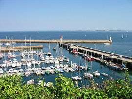 Port Tudy, main harbor of Groix island | |
.svg.png) Coat of arms | |
Location of Groix 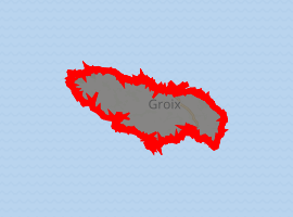
| |
 Groix  Groix | |
| Coordinates: 47°38′22″N 3°27′13″W | |
| Country | France |
| Region | Brittany |
| Department | Morbihan |
| Arrondissement | Lorient |
| Canton | Lorient-2 |
| Intercommunality | Lorient Agglomération |
| Government | |
| • Mayor (2008—2014) | Eric Regenermel |
| Area 1 | 14.82 km2 (5.72 sq mi) |
| Population (2017-01-01)[1] | 2,263 |
| • Density | 150/km2 (400/sq mi) |
| Time zone | UTC+01:00 (CET) |
| • Summer (DST) | UTC+02:00 (CEST) |
| INSEE/Postal code | 56069 /56590 |
| Elevation | 0–48 m (0–157 ft) |
| 1 French Land Register data, which excludes lakes, ponds, glaciers > 1 km2 (0.386 sq mi or 247 acres) and river estuaries. | |
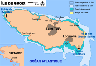
Groix lies a few kilometres off the coast of Lorient. Several ferries a day run from Lorient to Groix.
There are a few small towns on the island. High cliffs are on its north coast and sandy beaches in secluded coves on the south coast. Groix is also home to a wide variety of sea birds. Groix is also famous for hosting the only convex beach in Europe, which also moves following sea currents. During the last 15 years, the beach moved half a kilometer westbound.
The geology of Groix is distinct from that of the nearby continent, and the east and south coasts have been designated a mineral nature reserve since 1982. More than 60 minerals can be found on the island, particularly blue glaucophane (observable on the surface), epidote or garnet. The island mainly consists of schist.
A naval battle between Britain and France took place off Groix in 1795. Groix provides a dramatic backdrop for the fourth novel of Peter May's "Enzo" series, Freeze Frame, published in 2010.[2]
Climate
| Climate data for Groix (1981–2010 averages) | |||||||||||||
|---|---|---|---|---|---|---|---|---|---|---|---|---|---|
| Month | Jan | Feb | Mar | Apr | May | Jun | Jul | Aug | Sep | Oct | Nov | Dec | Year |
| Record high °C (°F) | 15.4 (59.7) |
16.6 (61.9) |
22.8 (73.0) |
25.8 (78.4) |
29.7 (85.5) |
35.6 (96.1) |
35.3 (95.5) |
35.2 (95.4) |
31.0 (87.8) |
26.5 (79.7) |
19.5 (67.1) |
16.0 (60.8) |
35.6 (96.1) |
| Average high °C (°F) | 9.5 (49.1) |
9.5 (49.1) |
11.5 (52.7) |
13.6 (56.5) |
16.6 (61.9) |
19.2 (66.6) |
21.0 (69.8) |
21.3 (70.3) |
19.8 (67.6) |
16.3 (61.3) |
12.7 (54.9) |
10.2 (50.4) |
15.1 (59.2) |
| Average low °C (°F) | 5.7 (42.3) |
5.3 (41.5) |
6.8 (44.2) |
7.9 (46.2) |
10.8 (51.4) |
13.3 (55.9) |
15.1 (59.2) |
15.3 (59.5) |
13.8 (56.8) |
11.7 (53.1) |
8.8 (47.8) |
6.4 (43.5) |
10.1 (50.2) |
| Record low °C (°F) | −9.4 (15.1) |
−8.0 (17.6) |
−6.2 (20.8) |
−1.0 (30.2) |
0.4 (32.7) |
5.8 (42.4) |
7.8 (46.0) |
8.4 (47.1) |
7.6 (45.7) |
1.8 (35.2) |
−2.4 (27.7) |
−6.0 (21.2) |
−9.4 (15.1) |
| Average precipitation mm (inches) | 95.7 (3.77) |
70.6 (2.78) |
65.0 (2.56) |
61.3 (2.41) |
59.2 (2.33) |
42.2 (1.66) |
42.7 (1.68) |
39.1 (1.54) |
56.4 (2.22) |
92.3 (3.63) |
91.3 (3.59) |
98.9 (3.89) |
814.7 (32.07) |
| Average relative humidity (%) | 87 | 86 | 85 | 82 | 84 | 83 | 83 | 83 | 83 | 86 | 86 | 88 | 84.7 |
| Source 1: Météo France[3] | |||||||||||||
| Source 2: Infoclimat.fr (humidity, 1961–1990)[4] | |||||||||||||
Demographics
Inhabitants of Groix are called Groisillons.
References
- "Populations légales 2017". INSEE. Retrieved 6 January 2020.
- May, Peter. Freeze Frame. Poison Pen Press: Scottsdale, Ariz., 2010. ISBN 1590587081
- "Données climatiques de la station de Ile de Groix" (in French). Meteo France. Retrieved December 30, 2015.
- "Normes et records 1961-1990: Ile de Groix - Beg Melen (56) - altitude 42m" (in French). Infoclimat. Retrieved December 30, 2015.
Bibliography
External links
- Official site (in French)
- Ile de Groix
- Groix info
- Ile-de-groix.info
- Geomorphology of the area
- French Ministry of Culture list for Groix (in French)
| Wikimedia Commons has media related to Groix. |
| Authority control |
|
|---|