Greenfield, New Hampshire
Greenfield is a town in Hillsborough County, New Hampshire, United States. The population was 1,749 at the 2010 census.[1] Greenfield is home to the Crotched Mountain Rehabilitation Center, to Greenfield State Park, and to part of the Wapack Trail.
Greenfield, New Hampshire | |
|---|---|
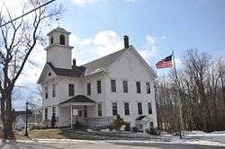 Town Hall | |
 Seal | |
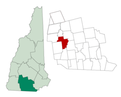 Location in Hillsborough County, New Hampshire | |
| Coordinates: 42°57′02″N 71°52′20″W | |
| Country | United States |
| State | New Hampshire |
| County | Hillsborough |
| Incorporated | 1791 |
| Government | |
| • Board of Selectmen | Robert S. Marshall, Chair Margaret Charig Bliss Karen Day |
| • Town Administrator | Aaron K. Patt |
| Area | |
| • Total | 26.6 sq mi (69.0 km2) |
| • Land | 26.1 sq mi (67.6 km2) |
| • Water | 0.5 sq mi (1.4 km2) 2.09% |
| Elevation | 840 ft (256 m) |
| Population (2010) | |
| • Total | 1,749 |
| • Density | 66/sq mi (25/km2) |
| Time zone | UTC-5 (Eastern) |
| • Summer (DST) | UTC-4 (Eastern) |
| ZIP code | 03047 |
| Area code(s) | 603 Exchange: 547 |
| FIPS code | 33-31540 |
| GNIS feature ID | 0873611 |
| Website | www |
History
Originally known as "Lyndeborough Addition", the area was first settled by the Lynde family in 1753. Separated from the nearest church and school by the Monadnock hills, the residents successfully petitioned to form a new town in 1791, using the name "Greenfield" to highlight the area's level, fertile ground.[2]
In 1953, the Crotched Mountain Rehabilitation Center began operation in Greenfield. Established by Harry Gregg, the facility on Crotched Mountain originally treated for polio, cerebral palsy, spina bifida and other physical and neurological disabilities. A center for adult rehabilitation would open in 1961, and a rehabilitation center for adults with brain injuries in 1986. The complex today provides service to over 2,000 children and adults. In 2004, it unveiled the first wheelchair-accessible treehouse in New Hampshire.
Greenfield is home to the Yankee Siege, considered the most powerful (current) trebuchet in the world, which has participated in the annual World Championship Punkin' Chunkin' Contest in Sussex County, Delaware since 2004. The farthest official toss is 1,897 feet (578 m) as of 2008, although there are unofficial reports of 2,000-to-2,300-foot (610 to 700 m) throws as of 2009.
 Bird's-eye view in 1907
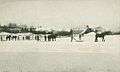 Harvesting ice c. 1907
 Town graveyard
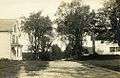 Bennington Road c. 1912
.jpg) Old Hancock-Greenfield Bridge
Old Hancock-Greenfield Bridge
Geography
According to the United States Census Bureau, the town has a total area of 26.6 square miles (68.9 km2), of which 26.1 square miles (67.6 km2) is land and 0.5 square miles (1.3 km2) is water, comprising 2.09% of the town.[3] Greenfield is drained by Stony Brook, Otter Brook and the Contoocook River; the town lies fully within the Merrimack River watershed.[4] North Pack Monadnock Mountain, elevation 2,276 feet (694 m) above sea level, is the northernmost summit of the Wapack Range and the highest point in Greenfield.
Adjacent municipalities
- Bennington, New Hampshire (north)
- Francestown, New Hampshire (northeast)
- Lyndeborough, New Hampshire (east)
- Temple, New Hampshire (south)
- Peterborough, New Hampshire (west)
- Hancock, New Hampshire (northwest)
Demographics
| Historical population | |||
|---|---|---|---|
| Census | Pop. | %± | |
| 1800 | 934 | — | |
| 1810 | 980 | 4.9% | |
| 1820 | 974 | −0.6% | |
| 1830 | 946 | −2.9% | |
| 1840 | 834 | −11.8% | |
| 1850 | 716 | −14.1% | |
| 1860 | 692 | −3.4% | |
| 1870 | 527 | −23.8% | |
| 1880 | 649 | 23.1% | |
| 1890 | 607 | −6.5% | |
| 1900 | 605 | −0.3% | |
| 1910 | 574 | −5.1% | |
| 1920 | 417 | −27.4% | |
| 1930 | 394 | −5.5% | |
| 1940 | 407 | 3.3% | |
| 1950 | 430 | 5.7% | |
| 1960 | 538 | 25.1% | |
| 1970 | 1,058 | 96.7% | |
| 1980 | 972 | −8.1% | |
| 1990 | 1,519 | 56.3% | |
| 2000 | 1,657 | 9.1% | |
| 2010 | 1,749 | 5.6% | |
| Est. 2017 | 1,858 | [5] | 6.2% |
| U.S. Decennial Census[6] | |||
As of the census[7] of 2000, there were 1,657 people, 563 households, and 405 families residing in the town. The population density was 65.1 people per square mile (25.1/km²). There were 640 housing units at an average density of 25.1 per square mile (9.7/km²). The racial makeup of the town was 97.28% White, 0.72% African American, 0.84% Native American, 0.24% Asian, 0.48% from other races, and 0.42% from two or more races. Hispanic or Latino of any race were 0.60% of the population.
There were 563 households out of which 38.9% had children under the age of 18 living with them, 60.0% were married couples living together, 8.0% had a female householder with no husband present, and 27.9% were non-families. 19.5% of all households were made up of individuals and 4.3% had someone living alone who was 65 years of age or older. The average household size was 2.69 and the average family size was 3.12.
In the town, the population was spread out with 30.8% under the age of 18, 7.3% from 18 to 24, 32.1% from 25 to 44, 22.8% from 45 to 64, and 7.1% who were 65 years of age or older. The median age was 34 years. For every 100 females, there were 104.1 males. For every 100 females age 18 and over, there were 105.9 males.
The median income for a household in the town was $48,833, and the median income for a family was $56,250. Males had a median income of $36,250 versus $24,438 for females. The per capita income for the town was $19,895. About 2.4% of families and 5.4% of the population were below the poverty line, including 6.9% of those under age 18 and 8.5% of those age 65 or over.
References
- United States Census Bureau, U.S. Census website, 2010 Census figures. Retrieved March 23, 2011.
- Coolidge, Austin J.; John B. Mansfield (1859). A History and Description of New England. Boston, Massachusetts: A.J. Coolidge. pp. 509.
coolidge mansfield history description new england 1859.
- "Geographic Identifiers: 2010 Demographic Profile Data (G001) - Greenfield town, New Hampshire". United States Census Bureau. Retrieved November 7, 2011.
- Foster, Debra H.; Batorfalvy, Tatianna N.; Medalie, Laura (1995). Water Use in New Hampshire: An Activities Guide for Teachers. U.S. Department of the Interior and U.S. Geological Survey.
- "Annual Estimates of the Resident Population: April 1, 2010 to July 1, 2017 (PEPANNRES): Minor Civil Divisions – New Hampshire". Archived from the original on February 13, 2020. Retrieved November 15, 2018.
- "Census of Population and Housing". Census.gov. Retrieved June 4, 2016.
- "U.S. Census website". United States Census Bureau. Retrieved 2008-01-31.
External links
| Wikimedia Commons has media related to Greenfield, New Hampshire. |
- Town of Greenfield official website
- Crotched Mountain Rehabilitation Center
- Friends of the Wapack Trail
- Greenfield State Park
- New Hampshire Economic and Labor Market Information Bureau Profile
Places adjacent to Greenfield, New Hampshire | |
|---|---|
Municipalities and communities of Hillsborough County, New Hampshire, United States | ||
|---|---|---|
| Cities |  Map of New Hampshire highlighting Hillsborough County | |
| Towns | ||
| CDPs | ||
| Other villages | ||
| Authority control |
|
|---|