Amherst (CDP), New Hampshire
Amherst is a census-designated place (CDP) and the main village in the town of Amherst in Hillsborough County, New Hampshire, United States. The population of the CDP was 613 at the 2010 census,[1] out of 11,201 people in the entire town of Amherst. The community is also listed by the National Register of Historic Places as the Amherst Village Historic District.
Amherst, New Hampshire | |
|---|---|
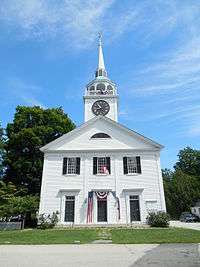 Congregational Church of Amherst | |
 Amherst  Amherst | |
| Coordinates: 42°51′49″N 71°37′32″W | |
| Country | United States |
| State | New Hampshire |
| County | Hillsborough |
| Town | Amherst |
| Area | |
| • Total | 0.73 sq mi (1.88 km2) |
| • Land | 0.73 sq mi (1.88 km2) |
| • Water | 0.0 sq mi (0.0 km2) |
| Elevation | 264 ft (80 m) |
| Population (2010) | |
| • Total | 613 |
| • Density | 844/sq mi (325.8/km2) |
| Time zone | UTC-5 (Eastern (EST)) |
| • Summer (DST) | UTC-4 (EDT) |
| ZIP code | 03031 |
| Area code(s) | 603 |
| FIPS code | 33-01220 |
| GNIS feature ID | 2629710 |
Geography
The CDP is in the central part of the town of Amherst, bordered to the east by New Hampshire Route 101; to the south by Thornton Ferry Road, Courthouse Road, and Atherton Lane; to the west by Old Milford Road and the west edge of Meadow View Cemetery; and to the north by Jones Road, Mack Hill Road, and Manchester Road.[2]
Route 101 leads northeast 10 miles (16 km) to the start of the Manchester bypass, and southwest 10 miles (16 km) to Wilton. Milford is 2.5 miles (4.0 km) to the southwest via Amherst Street.
According to the U.S. Census Bureau, the Amherst CDP has a total area of 0.73 square miles (1.88 km2), all of it land.[1]
Demographics
As of the census of 2010, there were 613 people, 241 households, and 186 families residing in the CDP. There were 254 housing units, of which 13, or 5.1%, were vacant. The racial makeup of the CDP was 99.0% white, 0.0% African American, 0.0% Native American, 0.7% Asian, 0.0% Pacific Islander, 0.0% some other race, and 0.3% from two or more races. 0.8% of the population were Hispanic or Latino of any race.[3]
Of the 241 households in the CDP, 38.2% had children under the age of 18 living with them, 65.1% were headed by married couples living together, 9.5% had a female householder with no husband present, and 22.8% were non-families. 19.9% of all households were made up of individuals, and 12.0% were someone living alone who was 65 years of age or older. The average household size was 2.54, and the average family size was 2.94.[3]
27.1% of residents in the CDP were under the age of 18, 3.9% were from age 18 to 24, 18.0% were from 25 to 44, 31.2% were from 45 to 64, and 19.9% were 65 years of age or older. The median age was 45.6 years. For every 100 females, there were 88.6 males. For every 100 females age 18 and over, there were 89.4 males.[3]
For the period 2011-15, the estimated median annual income for a household was $112,344, and the median income for a family was $141,382. The per capita income for the CDP was $63,381. 4.3% of the population and 0.0% of families were below the poverty line, along with 0.0% of people under the age of 18 and 0.0% of people 65 or older.[4]
References
- "Geographic Identifiers: 2010 Demographic Profile Data (G001): Amherst CDP, New Hampshire". U.S. Census Bureau, American Factfinder. Archived from the original on February 13, 2020. Retrieved September 6, 2017.
- "TIGERweb: Amherst CDP, New Hampshire". Geography Division, U.S. Census Bureau. Retrieved September 6, 2017.
- "Profile of General Population and Housing Characteristics: 2010 Census Summary File 1 (DP-1): Amherst CDP, New Hampshire". U.S. Census Bureau, American Factfinder. Archived from the original on February 13, 2020. Retrieved September 6, 2017.
- "Selected Economic Characteristics: 2011-2015 American Community Survey 5-Year Estimates (DP03): Amherst CDP, New Hampshire". U.S. Census Bureau, American Factfinder. Archived from the original on February 13, 2020. Retrieved September 6, 2017.
Municipalities and communities of Hillsborough County, New Hampshire, United States | ||
|---|---|---|
| Cities |  Map of New Hampshire highlighting Hillsborough County | |
| Towns | ||
| CDPs | ||
| Other villages | ||