Gravedona ed Uniti
Gravedona ed Uniti is a comune (municipality) in the Province of Como in the Italian region Lombardy, located about 80 kilometres (50 mi) north of Milan and about 40 kilometres (25 mi) northeast of Como.
Gravedona ed Uniti | |
|---|---|
| Comune di Gravedona ed Uniti | |
 | |
Location of Gravedona ed Uniti 
| |
 Gravedona ed Uniti Location of Gravedona ed Uniti in Italy 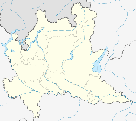 Gravedona ed Uniti Gravedona ed Uniti (Lombardy) | |
| Coordinates: 46°9′N 9°18′E | |
| Country | Italy |
| Region | Lombardy |
| Province | Province of Como (CO) |
| Frazioni | Negrana, San Carlo, Segna, Trevisa, Traversa, Germasino, Consiglio di Rumo |
| Government | |
| • Mayor | Fiorenzo Bongiasca (No-party) |
| Area | |
| • Total | 40.8 km2 (15.8 sq mi) |
| Elevation | 201 m (659 ft) |
| Population (May 2011)[2] | |
| • Total | 4,222 |
| • Density | 100/km2 (270/sq mi) |
| Demonym(s) | Gravedonesi |
| Time zone | UTC+1 (CET) |
| • Summer (DST) | UTC+2 (CEST) |
| Postal code | 22015 |
| Dialing code | 0344 |
| Website | www.comune.gravedonaeduniti.co.it |

The municipality of Gravedona ed Uniti contains the frazioni (subdivisions, mainly villages and hamlets) of Negrana, San Carlo, Segna, Trevisa, Traversa and, following an act of fusion passed by Lombardy Region, the annexed former municipalities of Consiglio di Rumo and Germasino, included on May 16, 2011.[3]
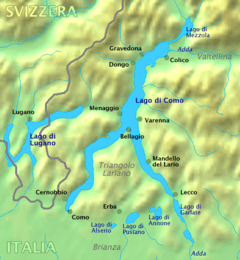
The town of Gravedona has a small harbour and overlooks Lake Como and the eastern shoreline. On 31 December 2004, it had a population of 2,669 and an area of 6.2 square kilometres (2.4 sq mi).[4] After the enlargement of 2011, the municipality rose to an area of 40.8 square kilometres (15.8 sq mi) and a population of 4,222 inhabitants.
Gravedona ... is situated at the mouth of a gorge. The handsome Palazzo del Pero with four towers, at the upper end, was built in 1586 by Pellegrino Tibaldi for the Milanese Cardinal Tolomeo Gallio. Adjoining the venerable church of San Vincenzo rises the 12th century Romanesque Baptistery of Santa Maria del Tiglio, with campanile, containing two Christian inscriptions of the 5th century.[5]
Gravedona ed Uniti borders the following municipalities: Colico, Domaso, Dongo, Dosso del Liro, Garzeno, San Nazzaro Val Cavargna, Peglio, Stazzona and, in Switzerland, Roveredo, Sant'Antonio and San Vittore.
Demographic evolution

References
- "Superficie di Comuni Province e Regioni italiane al 9 ottobre 2011". Istat. Retrieved 16 March 2019.
- "Popolazione Residente al 1° Gennaio 2018". Istat. Retrieved 16 March 2019.
- "Deliberazione del Consiglio Comunale". Comune di Gravedona. 07-05-10. Retrieved May 31, 2011. Check date values in:
|date=(help) - All demographics and other statistics: Italian statistical institute Istat.
- "Gravedona". Italy: handbook for travellers by Karl Baedeker. vol. 1 (12th ed.). 1903. p. 160.
| Wikimedia Commons has media related to Gravedona ed Uniti. |
| Settlements |
|  |
|---|---|---|
| Islands | ||
| Rivers | ||
| Valleys | ||
| Mountains | ||
| Landmarks |
| |
| Films | ||
| People | ||
| Authority control |
|
|---|