Grafling
Grafling is a municipality in the district of Deggendorf in Bavaria in Germany.
Grafling | |
|---|---|
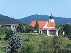 Saint Andrew Church | |
 Coat of arms | |
Location of Grafling within Deggendorf district 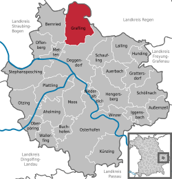 | |
 Grafling  Grafling | |
| Coordinates: 48°54′N 12°59′E | |
| Country | Germany |
| State | Bavaria |
| Admin. region | Niederbayern |
| District | Deggendorf |
| Government | |
| • Mayor | Willibald Zißlsberger (CSU) |
| Area | |
| • Total | 46.28 km2 (17.87 sq mi) |
| Elevation | 433 m (1,421 ft) |
| Population (2018-12-31)[1] | |
| • Total | 2,795 |
| • Density | 60/km2 (160/sq mi) |
| Time zone | CET/CEST (UTC+1/+2) |
| Postal codes | 94539 |
| Dialling codes | 0991 |
| Vehicle registration | DEG |
| Website | www.grafling.de |
Geography
Grafling lies in the Danube Forest Planning Region (Planungsregion Donau-Wald). Its lowest point is in Großtiefenbach at 326 m above sea level (NN). The highest points of the municipality are the Steinberg (999 m), the Geißriegel (1,043 m), the Dreitannenriegel (1,090 m) and the Einödriegel (1,121 m) which rise above the valley of the Graflinger Tal to the east. To the north the valley ends at the Hochberg (727 m), to the west it is guarded by the Butzen (775 m) and the Vogelsang (1,022 m) in the municipality of Bernried. To the south the valley opens up towards Deggendorf, the Danube Plain, and the Gäuboden.
References
- "Fortschreibung des Bevölkerungsstandes". Bayerisches Landesamt für Statistik und Datenverarbeitung (in German). July 2019.
Towns and municipalities in Deggendorf (district) | ||
|---|---|---|
Coat of Arms of Deggendorf district | ||
This article is issued from Wikipedia. The text is licensed under Creative Commons - Attribution - Sharealike. Additional terms may apply for the media files.