Grade I listed buildings in Harrogate (borough)
There are over 9,000 Grade I listed buildings in England. This page is a list of these buildings in the district of Harrogate in North Yorkshire.
Harrogate
| Name | Location | Type | Architect | Completed [note 1] | Date designated | Grid ref.[note 2] Geo-coordinates |
Entry number [note 3] | Image | Ref. |
|---|---|---|---|---|---|---|---|---|---|
| Allerton Castle | Allerton Park, Allerton Mauleverer with Hopperton | House | 1721 | 15 March 1966 | SE4141658089 54°01′02″N 1°22′10″W |
1189430 | |||
| Church of St James | Baldersby St James, Baldersby | Church | 1856-58 | 26 May 1971 | SE3662376957 54°11′14″N 1°26′25″W |
1296495 | |||
| Lych Gate to Church of St James | Baldersby St James, Baldersby | Lych Gate | 1856-8 | 26 May 1971 | SE3660676919 54°11′12″N 1°26′26″W |
1315555 | 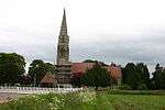 Lych Gate to Church of St James | ||
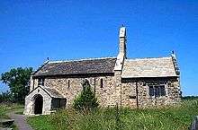
| Church of St Helen | Bilton-in-Ainsty | Church | 12th century | 30 March 1966 | SE4760450382 53°56′50″N 1°16′34″W |
1315388 |  Church of St Helen | [1] | |
| Syningthwaite Priory Farmhouse | Bilton in Ainsty | Farmhouse | 12th century | 2 September 1952 | SE4615448686 53°55′56″N 1°17′55″W |
1150361 |  | ||
| Church of St Andrew | Aldborough | Church | 16th century | 15 March 1966 | SE4059966430 54°05′32″N 1°22′51″W |
1173835 | 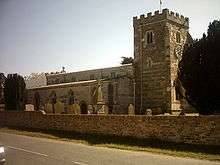 Church of St Andrew | ||
| Denton Hall and Attached Forecourt Walls and Railings | Denton | House | 1778 | 6 February 1952 | SE1476548694 53°56′03″N 1°46′36″W |
1315354 | 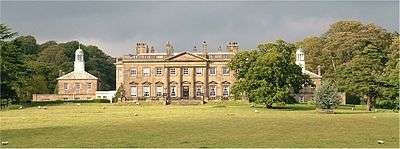 Denton Hall and Attached Forecourt Walls and Railings | ||
| Church of St Oswald | Farnham | Church | 12th century | 15 March 1966 | SE3481160584 54°02′24″N 1°28′12″W |
1150301 | 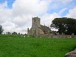 Church of St Oswald | [2] | |
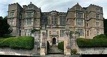
| Farnley Hall | Farnley | Country House | John Carr | 17th century | 6 February 1952 | SE2151947276 53°55′16″N 1°40′26″W |
1150040 | 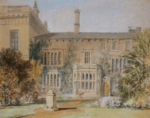 Farnley Hall | [3] |
| Rudding Park House | Rudding Lane, Follifoot | House | 1805-24 | 8 March 1952 | SE3341853164 53°58′24″N 1°29′31″W |
1188343 | 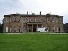 Rudding Park House | [4] | |
| Brimham Lodge | Brimham Road, Hartwith cum Winsley | House | 1661 | 3 March 1987 | SE2271363298 54°03′54″N 1°39′16″W |
1150538 | 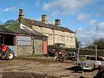 Brimham Lodge | [5] | |
| Church of All Saints | Kirby Hill | Church | 10th century | 20 June 1966 | SE3932268598 54°06′42″N 1°24′00″W |
1190293 | 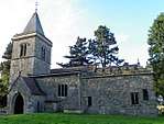 Church of All Saints | ||
| Church of All Saints | Kirk Deighton | Church | Early-mid 15th century | 30 March 1966 | SE3988250524 53°56′57″N 1°23′38″W |
1294634 | [6] | ||
| Church of St John the Baptist | Kirk Hammerton | Church | 11th century | 15 March 1966 | SE4652455525 53°59′37″N 1°17′31″W |
1149932 | 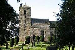 Church of St John the Baptist | ||
| Church of St Andrew | Kirkby Malzeard | Church | 12th century | 6 March 1967 | SE2354774527 54°09′58″N 1°38′27″W |
1173967 | 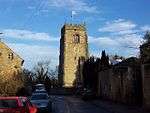 Church of St Andrew | ||
| Chapel of Our Lady of the Crag | Knaresborough | Chapel | Early 15th century | 5 February 1952 | SE3513556447 54°00′10″N 1°27′56″W |
1149913 | 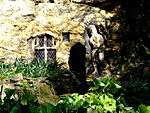 Chapel of Our Lady of the Crag | ||
| Church of Saint John the Baptist | Knaresborough | Parish Church | Late 12th century | 5 February 1952 | SE3471257185 54°00′34″N 1°28′19″W |
1293930 |  Church of Saint John the Baptist | ||
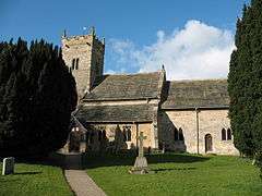
| Church of St Oswald | Leathley | Church | 12th century | 22 November 1966 | SE2318847010 53°55′07″N 1°38′54″W |
1174461 | 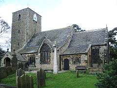 Church of St Oswald | ||
| Banqueting House at Studley Royal | Studley Park, Lindrick With Studley Royal And Fountains | Banqueting House | 1728–32 | 6 March 1967 | SE2781268901 54°06′55″N 1°34′34″W |
1150608 |  Banqueting House at Studley Royal | [7] | |
| Canal Approximately 500 Metres Long, with the Drum Falls and Weir Inlet | Studley Park, Lindrick with Studley Royal and Fountains | Canal | c1718-1728 | 11 June 1986 | SE2799068929 54°06′56″N 1°34′24″W |
1173904 | 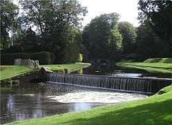 Canal Approximately 500 Metres Long, with the Drum Falls and Weir Inlet | ||
| Temple of Piety on East Side of Moon Pond | Studley Park, Lindrick with Studley Royal and Fountains | Garden Building | Completed 1742 | 6 March 1967 | SE2808968786 54°06′51″N 1°34′19″W |
1150613 |  Temple of Piety on East Side of Moon Pond | ||
| Tunnel approximately 20 Metres West of the Octagon, with Flanking Wall attached to South | Studley Park, Lindrick with Studley Royal and Fountains | Tunnel | c. 1730 | 11 June 1986 | SE2805468982 54°06′57″N 1°34′20″W |
1150610 |  Tunnel approximately 20 Metres West of the Octagon, with Flanking Wall attached to South | ||
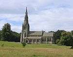
| Church of St Mary | Studley Park, Lindrick with Studley Royal and Fountains | Church | 1871-78 | 6 March 1967 | SE2754169291 54°07′08″N 1°34′49″W |
1315267 | |||
| Fountains Abbey with ancillary buildings | Lindrick with Studley Royal and Fountains | Abbey | Romanesque | 11 June 1986 | SE2749468282 54°06′35″N 1°34′51″W |
1149811 |  Fountains Abbey with ancillary buildings | ||
| Abbey Mill at Fountains Abbey | Lindrick with Studley Royal and Fountains | Mill | Mid 12th century | 11 June 1986 | SE2725668193 54°06′32″N 1°35′05″W |
1173325 | 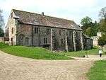 Abbey Mill at Fountains Abbey | ||
| Fountains Hall | Lindrick with Studley Royal and Fountains | Country House | 1598-1611 | 23 April 1952 | SE2713668289 54°06′35″N 1°35′11″W |
1149809 | |||
| Church of the Holy Trinity, Little Ouseburn | Little Ouseburn | Church | 11th century | 15 March 1966 | SE4523761139 54°02′39″N 1°18′38″W |
1150296 | [8] | ||
| Swinsty Hall | Little Timble | House | Late C16-Early 17th century | 14 July 1987 | SE1936453197 53°58′28″N 1°42′23″W |
1174496 | 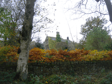 Swinsty Hall | ||
| Church of All Saints | Long Marston | Church | c. 1400 | 30 March 1966 | SE5051750777 53°57′02″N 1°13′54″W |
1150327 | 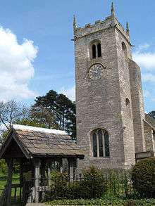 Church of All Saints | [9] | |
| Markenfield Hall | Markingfield Hall | Kitchen | Early 15th century | 23 April 1952 | SE2945567395 54°06′06″N 1°33′04″W |
1293954 | |||
| Church of Christ the Consoler, with Eleanor Cross to east | Skelton-on-Ure, Newby with Mulwith | Church | 1871-76 | 6 March 1967 | SE3599567951 54°06′22″N 1°27′04″W |
1315406 | 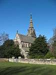 Church of Christ the Consoler, with Eleanor Cross to east | ||
| Newby Hall | Newby with Mulwith | Country House | c1695-1697 | 23 April 1952 | SE3478667436 54°06′06″N 1°28′10″W |
1150307 | |||
| Skelton Lodges to Newby Hall with Attached Gates and Screen Walls | Newby with Mulwith | Gate | c. 1777 | 6 March 1967 | SE3624167921 54°06′21″N 1°26′50″W |
1289365 | .jpg) Skelton Lodges to Newby Hall with Attached Gates and Screen Walls | ||
| Stables Approximately 150 Metres North of Newby Hall | Newby with Mulwith | Tack Room | 19th century | 23 April 1952 | SE3479267524 54°06′09″N 1°28′10″W |
1150308 | | ||
| Church of St Mary | Nun Monkton | Church | Late C12-Early 13th century | 15 March 1966 | SE5115357927 54°00′53″N 1°13′15″W |
1190942 | 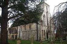 Church of St Mary | [10] | |
| Baldersby Park House | Rainton with Newby | House/School | Colen Campbell | 1718-21 | 10 July 1970 | SE3878776282 54°10′51″N 1°24′26″W |
1150028 | 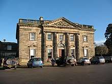 Baldersby Park House | [11] |
| Gatehouse approximately 80 metres south of Ripley Castle | Ripley | Gatehouse | Medieval | 8 March 1952 | SE2826560529 54°02′24″N 1°34′12″W |
1174136 | 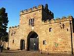 Gatehouse approximately 80 metres south of Ripley Castle | ||
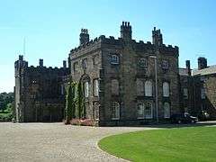
| Ripley Castle | Ripley Park, Ripley | House | Mid 16th century | 8 March 1952 | SE2822660557 54°02′25″N 1°34′14″W |
1315370 | |||
| Chapel of the Hospital of St Mary Magdalene | Ripon | Chapel | Medieval | 27 May 1949 | SE3172671779 54°08′27″N 1°30′57″W |
1150194 | .jpg) Chapel of the Hospital of St Mary Magdalene | ||
| The Obelisk | Ripon | Obelisk | Nicholas Hawksmoor | 1702 | 27 May 1949 | SE3121671270 54°08′11″N 1°31′25″W |
1315492 |  The Obelisk | [12] |
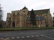
| Ripon Minster (cathedral Church of St Peter and Wilfrid) | Ripon | Cathedral | 14th century | 27 May 1949 | SE3144671129 54°08′06″N 1°31′13″W |
1150164 | |||
| Stockeld Park House | Spofforth with Stockeld | Country House | James Paine | 1758-63 | 2 September 1952 | SE3720549075 53°56′11″N 1°26′05″W |
1149986 | [13] | |
| Church of St Mary | Stainburn | Church | 12th century | 22 November 1966 | SE2474648547 53°55′57″N 1°37′29″W |
1149989 | |||
| Church of St Michael | Cowthorpe, Tockwith | Church (redundant) | 1456-58 | 30 March 1966 | SE4270052692 53°58′07″N 1°21′02″W |
1315417 | [14] | ||
| Banqueting House Approximately 50 Metres East of Weston Hall | Weston Park, Weston | Banqueting House | Late C16-Early 17th century | 22 November 1966 | SE1786146738 53°54′59″N 1°43′46″W |
1150438 | | ||
| Church of All Saints | Weston Park, Weston | Church | Anglo-Saxon | 22 November 1966 | SE1774346624 53°54′56″N 1°43′53″W |
1150440 | 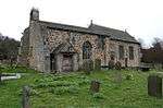 Church of All Saints | ||
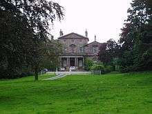
| Weston Hall | Weston Park, Weston | House | Mid 18th century | 6 February 1952 | SE1779846711 53°54′58″N 1°43′50″W |
1150437 | 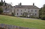 Weston Hall | ||
| Church of All Saints | Wighill | Church | 15th century | 30 March 1966 | SE4736046577 53°54′47″N 1°16′50″W |
1315379 | 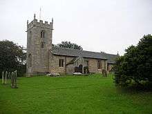 Church of All Saints | [15] | |
| Church of St Wilfrid | Duchy Road, Harrogate | Church | Temple Moore | 1909-14 | 4 February 1975 | SE2941255554 53°59′43″N 1°33′10″W |
1189773 | [16] |
.jpg)

.jpg)
Jun2004.jpg)
Sep2003.jpg)

.jpg)
Notes
- The date given is the date used by Historic England as significant for the initial building or that of an important part in the structure's description.
- Sometimes known as OSGB36, the grid reference is based on the British national grid reference system used by the Ordnance Survey.
- The "List Entry Number" is a unique number assigned to each listed building and scheduled monument by Historic England.
References
- "Church Of St Helen:LBS Number 331703". heritagegateway. Retrieved 2009-02-09.
- "Church Of St Oswald:LBS Number 331771". heritagegateway. Retrieved 2009-02-03.
- "Farnley Hall:LBS Number 330482". heritagegateway. Retrieved 2009-01-24.
- "Rudding Park House:LBS Number 1188343". heritagegateway. Retrieved 2009-01-29.
- "Brimham Lodge:LBS Number 331216". heritagegateway. Retrieved 2009-01-29.
- "Church Of All Saints:LBS Number 331716". heritagegateway. Retrieved 2009-02-09.
- "Banqueting House Approximately 100 Metres To West Of The Canal:LBS Number 331073". heritagegateway. Retrieved 2009-01-29.
- "Church Of The Holy Trinity:LBS Number 331859". heritagegateway. Retrieved 2009-01-29.
- "Church Of All Saints:LBS Number 331726". heritagegateway. Retrieved 2009-02-09.
- "Church Of St Mary:LBS Number 331666". heritagegateway. Retrieved 2009-02-10.
- "Baldersby Park House:LBS Number 330444". heritagegateway. Retrieved 2009-01-24.
- "Obelisk:LBS Number 330147". heritagegateway. Retrieved 2009-01-24.
- "Stockeld Park House:LBS Number 1149986". heritagegateway. Retrieved 2009-01-24.
- "Church Of St Michael:LBS Number 331742". heritagegateway. Retrieved 2009-02-09.
- "Church Of All Saints:LBS Number 331752". heritagegateway. Retrieved 2009-02-09.
- "Church Of St Wilfrid:LBS Number 329866". heritagegateway. Retrieved 2009-02-03.
External links
![]()
This article is issued from Wikipedia. The text is licensed under Creative Commons - Attribution - Sharealike. Additional terms may apply for the media files.