Kirk Hammerton
Kirk Hammerton is a village and civil parish in the Harrogate district of North Yorkshire, England. It is near the River Nidd and the A59 road, 10 miles (16 km) west of York. The village suffix refers to the Hamerton family who owned the land until the 16th century.
| Kirk Hammerton | |
|---|---|
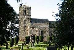 Saint John the Baptist parish church | |
 Kirk Hammerton Location within North Yorkshire | |
| Population | 538 (2011 Census)[1] |
| OS grid reference | SE466556 |
| Civil parish |
|
| District |
|
| Shire county | |
| Region | |
| Country | England |
| Sovereign state | United Kingdom |
| Post town | YORK |
| Postcode district | YO26 |
| Police | North Yorkshire |
| Fire | North Yorkshire |
| Ambulance | Yorkshire |
| UK Parliament | |
History
(H)ambretone, a place-name reflected now in both Kirk Hammerton ("Hammerton with the church", from the Old Norse kirkja = "church") and Green Hammerton ("Hammerton with the green", from Middle English grene), is first attested in the Domesday Book of 1086. The name seems to derive from the Old English plant-name hamor (whose meaning is not certain but might include hammer-sedge or pellitory of the wall) + tūn 'settlement, farm, estate'.[2] The course of Rudgate, a Roman road, passes the village.[3]
The lands of the parish used to be held by the Hamerton family of Hellifield Peel Castle, part of their estate stretching from Slaidburn to York. The family name died with Sir Stephen Hamerton when he was hanged for treason at Tyburn in 1536 for participating in the Pilgrimage of Grace and his family died soon after.[4] The village and nearby Green Hammerton still bear their name.[5]
On 6 July 2014, Stage 2 of the 2014 Tour de France from York to Sheffield, passed through the village.[6]
Geography
The 2001 Census recorded a parish population of 517 people in 195 households. The village is mostly south of the A59 York – Liverpool road between York and Knaresborough. The River Nidd meanders to the south and east of the village. The parish also includes the small hamlet of Wilstrop.[7]
The parish is served by Hammerton railway station on the Harrogate Line which links York and Leeds. Cattal railway station is also within the parish boundary. Kirk Hammerton is 10 miles (16 km) west of York, 1 mile (1.6 km) south of Green Hammerton and 7 miles (11 km) east of Knaresborough. The parish has an area of 2,008 acres (813 ha).[7]
Governance
The parish is in the Selby and Ainsty parliamentary constituency. It is in the Ainsty ward of the North Yorkshire County Council and the Ribston Ward of Harrogate Borough Council.
The village Parish Council has six members.[8]
Education
The village has one primary school, Kirk Hammerton Church of England Primary School.[9] it also has a playgroup across the grounds of the school. Most pupils go on to get their secondary education at Boroughbridge High School.[10]
Religion
The Church of England parish church of St John the Baptist, was originally dedicated to Saint Quentin.[11] The original Anglo-Saxon church is on the south side of the church and now forms the Lady Chapel following a major enlargement of the building in 1892. The interior of the church is richly decorated in a pre-Raphaelite style; the decorations were added at the time of the Victorian extension to the building.
There is also a Wesleyan chapel that was established in 1821, and moved to a larger building in 1899.[7][12]
See also
- Kirk Hammerton Hall
References
- UK Census (2011). "Local Area Report – Kirk Hammerton Parish (E04007371)". Nomis. Office for National Statistics. Retrieved 6 April 2019.
- Watts, Victor, ed. (2004). The Cambridge Dictionary of English Place-Names Based on the Collections of the English Place-Name Society. Cambridge: Cambridge University Press. "Kirk Hammerton".
- "Kirk Hammerton Tourist Information". AboutBritain.com. Retrieved 15 October 2012.
- "Hellifield and The Hamertons". Hellifield Peel Castle. 2012. Retrieved 15 October 2012.
- "Hammerton Hall". Local History Associated With The Hodder Way. The Westmorland Gazette. Retrieved 15 October 2012.
- "Tour de France Stage 1". Archived from the original on 25 July 2014. Retrieved 15 July 2014.
- Bulmer's Topography, History and Directory (private & Commercial) of North Yorkshire with Map, Published in 1890. Salisbury: S&N Publishing. 2002 [1890]. pp. 875–876. ISBN 1-86150-299-0.
- "The Council". Kirk Hammerton Parish. Archived from the original on 15 January 2012. Retrieved 15 October 2012.
- "Primary School". Kirk Hammerton Parish. Archived from the original on 15 January 2012. Retrieved 15 October 2012.
- A Guide for Parents. North Yorkshire County Council. 2012. Archived from the original (PDF) on 4 October 2012. Retrieved 15 October 2012.
- "The Church". Kirk Hammerton Parish. Archived from the original on 15 January 2012. Retrieved 15 October 2012.
- "The Chapel". Kirk Hammerton Parish. Archived from the original on 15 January 2012. Retrieved 15 October 2012.
External links
| Wikimedia Commons has media related to Kirk Hammerton. |
- The ancient parish of Kirk Hammerton: historical and genealogical information at GENUKI.