Grade I and II* listed buildings in the London Borough of Havering
There are over 9,000 Grade I listed buildings and 20,000 Grade II* listed buildings in England. This page is a list of these buildings in the London Borough of Havering.
Grade I
| Name | Location | Type | Completed [note 1] | Date designated | Grid ref.[note 2] Geo-coordinates |
Entry number [note 3] | Image |
|---|---|---|---|---|---|---|---|
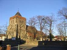
| Church of St Helen and St Giles | Havering | Church | c. 1170 | 7 January 1955 | TQ5208382208 51°31′06″N 0°11′26″E |
1358505 | |
| Church of St Laurence | Havering | Church | Medieval | 7 January 1955 | TQ5592986496 51°33′21″N 0°14′52″E |
1184679 | |
| Church of St Mary Magdalene | North Ockendon, Havering | Church | 12th century | 7 January 1955 | TQ5873984866 51°32′25″N 0°17′15″E |
1183610 | |
| Parish Church of St Andrew | Havering | Parish Church | 13th century | 7 January 1955 | TQ5440986968 51°33′38″N 0°13′34″E |
1358529 | |
| The Bower House | Havering Atte Bower, Havering | Country House | 1729 | 4 July 1952 | TQ5125492708 51°36′46″N 0°10′59″E |
1079873 | .jpg) The Bower House |
| Stable Block at the Bower House | Havering-atte-Bower, Havering | Stable | c. 1729 | 4 July 1952 | TQ5124392695 51°36′46″N 0°10′59″E |
1079874 | .jpg) Stable Block at the Bower House |
Grade II*
| Name | Location | Type | Completed [note 1] | Date designated | Grid ref.[note 2] Geo-coordinates |
Entry number [note 3] | Image |
|---|---|---|---|---|---|---|---|
| Bretons | Havering | House | Late 17th century | 7 January 1955 | TQ5169684862 51°32′32″N 0°11′10″E |
1079875 | 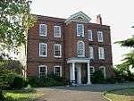 Bretons |
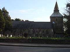
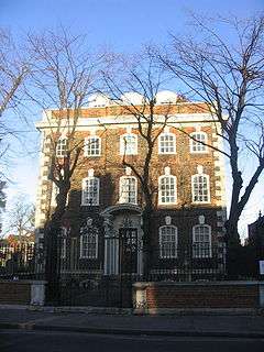
| Church of St Mary and St Peter | Wennington, Havering | Church | Medieval | 7 January 1955 | TQ5398780949 51°30′23″N 0°13′03″E |
1079886 | 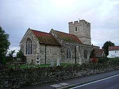 Church of St Mary and St Peter |
| Great Tomkyns | Havering | House | Modern | 7 January 1955 | TQ5666989498 51°34′57″N 0°15′35″E |
1184797 |  |
| Barn to North East of Great Tomkyns | Havering | Barn | 1727 | 7 January 1955 | TQ5668589611 51°35′01″N 0°15′36″E |
1358527 | |
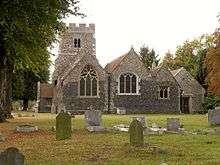
| High House Farmhouse | Corbets Tey, Havering | House | c. 1700 | 7 January 1955 | TQ5622585025 51°32′33″N 0°15′05″E |
1079867 | 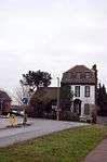 High House Farmhouse |
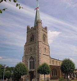
| Parish Church of St Edward the Confessor | Havering | Parish Church | 1849 | 4 July 1952 | TQ5119588957 51°34′45″N 0°10′50″E |
1358535 | 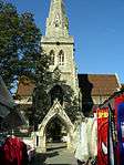 Parish Church of St Edward the Confessor |
| Rainham Hall | Havering | House | 1729 | 7 January 1955 | TQ5209982164 51°31′05″N 0°11′27″E |
1358506 | |
| Forecourt Railings, Gates and Piers Walls and Vases at Rainham Hall | Havering | Gate | Early 18th century | 7 January 1955 | TQ5208482158 51°31′04″N 0°11′26″E |
1079922 | 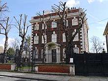 Forecourt Railings, Gates and Piers Walls and Vases at Rainham Hall |
| Stable Block at Rainham Hall | Havering | Stable | 18th century | 7 January 1955 | TQ5211582153 51°31′04″N 0°11′28″E |
1183554 | |
| The Lodge at Rainham Hall | Havering | House | Early 18th century | 7 January 1955 | TQ5209482149 51°31′04″N 0°11′26″E |
1079923 | |
| The Round House | Havering Atte Bower, Havering | Villa | 1792 | 4 July 1952 | TQ5148893136 51°37′00″N 0°11′12″E |
1183562 | |
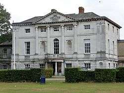
| The Royal Liberty School | Gidea Park, Havering | Country House | 1768-9 | 14 September 1979 | TQ5321289728 51°35′08″N 0°12′36″E |
1079885 | |
| Upminster Hall | Havering | House | 17th century | 7 January 1955 | TQ5659287682 51°33′59″N 0°15′28″E |
1079889 | |
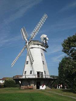
| Upminster Windmill | Havering | Smock Mill | Mid 19th century | 7 January 1955 | TQ5573486725 51°33′28″N 0°14′42″E |
1079878 | |
| Wrought Iron Screen and Gates with Piers at Bretons | Havering | Gate | c. 1740 | 7 January 1955 | TQ5173984853 51°32′32″N 0°11′12″E |
1358521 | |
Notes
- The date given is the date used by Historic England as significant for the initial building or that of an important part in the structure's description.
- Sometimes known as OSGB36, the grid reference is based on the British national grid reference system used by the Ordnance Survey.
- The "List Entry Number" is a unique number assigned to each listed building and scheduled monument by Historic England.
External links

| Districts |
|  |
|---|---|---|
| Attractions | ||
| Major retail |
| |
| Places of worship |
| |
| Parks and open spaces | ||
| Constituencies | ||
| Tube and rail stations | ||
| Other topics | ||
| ||
This article is issued from Wikipedia. The text is licensed under Creative Commons - Attribution - Sharealike. Additional terms may apply for the media files.