Grade II* listed buildings in Mole Valley
There are over 20,000 Grade II* listed buildings in England. This page is a list of the fifty Grade II* listed buildings in the district of Mole Valley, for links to similar lists for the other 10 districts of Surrey see Grade II* listed buildings in Surrey.
| Name | Location | Type | Completed [note 1] | Date designated | Grid ref.[note 2] Geo-coordinates |
Entry number [note 3] | Image |
|---|---|---|---|---|---|---|---|
| Church of St James | Abinger, Mole Valley | Church | Early 12th century | 11 November 1966 | TQ1149445957 51°12′07″N 0°24′20″W |
1378082 | |
| Church of St John the Baptist | Oakwood Hill, Abinger, Mole Valley | Church | 1879 | 11 November 1966 | TQ1278738036 51°07′50″N 0°23′22″W |
1028844 | .JPG) Church of St John the Baptist |
| Crossways Farm House | Abinger, Mole Valley | Farmhouse | 1610 | 11 November 1966 | 51°12′52″N 0°24′51″W | 1189524 |  |
| Goddards | Abinger Common, Abinger, Mole Valley | Country House | 1910 | 7 February 1972 | TQ1201945389 51°11′48″N 0°23′53″W |
1028841 | |
| Paddington Farmhouse | Abinger Hammer, Abinger, Mole Valley | Farmhouse | 16th century | 11 November 1966 | TQ1005847045 51°12′43″N 0°25′33″W |
1189342 | |
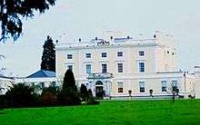
| Betchworth House | Betchworth, Mole Valley | Country House | Late 17th century | 11 November 1966 | TQ2110349547 51°13′56″N 0°16′01″W |
1028786 | .jpg) Betchworth House |
| The Old House | Betchworth, Mole Valley | House | Early 18th century | 11 November 1966 | TQ2108249831 51°14′05″N 0°16′01″W |
1293777 | .jpg) The Old House |
| Bonnetts | Capel, Mole Valley | House | 17th century | 11 November 1966 | TQ1679237750 51°07′38″N 0°19′57″W |
1378124 | 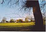 Bonnetts |
| Green's Farm House | Kingsland, Capel, Mole Valley | House | 16th century | 29 September 1987 | TQ1938141161 51°09′26″N 0°17′39″W |
1191632 | 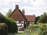 Green's Farm House |
| Taylors | Capel, Mole Valley | House | 16th century | 7 March 1977 | TQ1817938703 51°08′07″N 0°18′44″W |
1378127 | 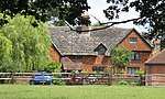 Taylors |
| Highworth Farmhouse | Charlwood, Mole Valley | Dairy | Late 15th century or Early 16th century | 11 November 1966 | TQ2308642594 51°10′10″N 0°14′27″W |
1248602 | |
| Providence Chapel | Charlwood, Mole Valley | Chapel | c. 1800 | 7 April 1983 | TQ2466241225 51°09′24″N 0°13′08″W |
1277978 | |
| The Manor House | Charlwood, Mole Valley | Hall House | 15th century or 16th century | 11 November 1966 | TQ2409941317 51°09′28″N 0°13′36″W |
1248380 | |
| Church of St Bartholomew | Leigh, Mole Valley | Church | 15th century | 11 November 1966 | TQ2245346944 51°12′31″N 0°14′54″W |
1028748 | 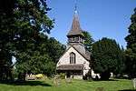 Church of St Bartholomew |
| Leigh Place | Leigh, Mole Valley | House | 17th century | 11 November 1966 | TQ2247147287 51°12′42″N 0°14′53″W |
1028747 | |
| Park House Farm House | Mynthurst, Leigh, Mole Valley | House | 17th century | 29 September 1987 | TQ2171644326 51°11′07″N 0°15′35″W |
1378119 | |
| Church of St Michael | Mickleham, Mole Valley | Church | 10th century | 28 November 1951 | TQ1706853376 51°16′03″N 0°19′24″W |
1028835 | .JPG) Church of St Michael |
| Juniper Hill | Mickleham, Mole Valley | Country House | c. 1780 | 28 November 1951 | TQ1712552936 51°15′49″N 0°19′22″W |
1028833 | |
| Norbury Park | Norbury Park, Mickleham, Mole Valley | Country House | 1774 | 28 November 1951 | TQ1598553706 51°16′15″N 0°20′20″W |
1228829 | |
| Stables and Kitchen Wings at Norbury Park | Norbury Park, Mickleham, Mole Valley | Kitchen | 28 November 1951 | TQ1593153708 51°16′15″N 0°20′22″W |
1228830 | | |
| The Old House | Mickleham, Mole Valley | House | 1636 | 28 November 1951 | TQ1707853580 51°16′10″N 0°19′23″W |
1028837 | |
| Church of St Peter | Newdigate, Mole Valley | Church | 12th century | 11 November 1966 | TQ1976442059 51°09′55″N 0°17′19″W |
1378141 | 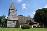 Church of St Peter |
| Hay Barn to South of Home Farm House | Newdigate, Mole Valley | Hay Barn | 1411-1422 | 11 November 1966 | TQ2068940704 51°09′10″N 0°16′33″W |
1028716 | |
| Home Farm House and Nos 1 and 2 Cottages | Newdigate, Mole Valley | House | 15th century | 11 November 1966 | TQ2066040742 51°09′12″N 0°16′34″W |
1378140 | |
| Old Barn at Home Farm | Newdigate, Mole Valley | Timber Framed Barn | 1484-1491 | 29 September 1987 | TQ2070040712 51°09′11″N 0°16′32″W |
1028717 | |
| Church of St Margaret | Ockley, Mole Valley | Church | 12th century | 11 November 1966 | TQ1568040655 51°09′12″N 0°20′50″W |
1028694 | .JPG) Church of St Margaret |
| Church of St Barnabas | Ranmore Common, Wotton, Mole Valley | Church | 1859 | 11 November 1966 | TQ1457050457 51°14′30″N 0°21′36″W |
1189879 | .JPG) Church of St Barnabas |
| Leith Hill Place | Wotton, Mole Valley | Country House | c. 1600 | 11 November 1966 | TQ1338342362 51°10′09″N 0°22′47″W |
1028801 | |
| The Temple, South of Wotton House | Wotton Park, Wotton, Mole Valley | Garden Temple | reputedly 1649 | 11 November 1966 | TQ1216246900 51°12′37″N 0°23′44″W |
1028807 | |
| Wotton House | Wotton, Mole Valley | Country House | Early 17th century | 11 March 1987 | TQ1216146966 51°12′39″N 0°23′44″W |
1189814 | |
| Ashtead Park Farm House | Ashtead Park, Mole Valley | House | c1730 rebuilt | 7 September 1951 | TQ1954458657 51°18′52″N 0°17′10″W |
1294698 | |
| Ashtead Park House and attached Balustrades |
Ashtead Park, Mole Valley | House | Completed 1790 | 7 September 1951 | TQ1951157928 51°18′29″N 0°17′13″W |
1028682 |  Ashtead Park House and attached Balustrades |
| Church of St Giles | Ashtead Park, Mole Valley | Parish Church | Early 12th century | 7 September 1951 | TQ1928658005 51°18′31″N 0°17′24″W |
1028685 | .JPG) Church of St Giles |
| Bury Hill Gardens | Westcott, Mole Valley | Coachmans Cottage | Mid 18th century | 28 November 1951 | TQ1483248744 51°13′35″N 0°21′25″W |
1228824 | 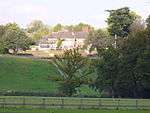 Bury Hill Gardens |
| Church of the Holy Trinity | Westcott, Mole Valley | Church | 1851-1852 | 11 June 1973 | TQ1395048420 51°13′25″N 0°22′11″W |
1227892 | .JPG) Church of the Holy Trinity |
| Church of All Saints | Little Bookham, Mole Valley | Church | c. 1100 | 7 September 1951 | TQ1229454017 51°16′27″N 0°23′30″W |
1028606 |  Church of All Saints |
| Church of St Martin | Dorking, Mole Valley | Church | 1868-1877 | 11 June 1973 | TQ1654049499 51°13′58″N 0°19′56″W |
1028904 | |
| Church of St Mary | Fetcham, Mole Valley | Parish Church | 11th century | 7 September 1951 | TQ1497755625 51°17′17″N 0°21′09″W |
1378187 | .JPG) Church of St Mary |
| Church of St Mary and St Nicholas | Leatherhead, Mole Valley | Parish Church | Late 11th century | 7 September 1951 | TQ1675456161 51°17′33″N 0°19′37″W |
1190429 | .JPG) Church of St Mary and St Nicholas |
| Fetcham Park House | Mole Valley | House | 1705-1710 | 7 September 1951 | TQ1500355674 51°17′19″N 0°21′08″W |
1188810 | |
| Le Pelerin | Fetcham, Mole Valley | Aisled House | 16th century or 17th century | 7 September 1951 | TQ1601256045 51°17′30″N 0°20′15″W |
1028662 | |
| Milton Court, including attached Forecourt Walls, Balustrading, Terrace, Piers, Urns and Ball Finials |
Westcott, Mole Valley | Dower House | 1611 | 11 June 1973 | TQ1514249349 51°13′54″N 0°21′08″W |
1230137 | 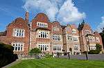 |
| Pippbrook House | Dorking, Mole Valley | Country House | Post medieval | 11 June 1973 | TQ1701049927 51°14′12″N 0°19′31″W |
1028875 | 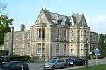 Pippbrook House |
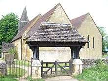
| Pixham Church | Dorking, Mole Valley | Church | 1901 | 11 June 1973 | TQ1761550289 51°14′23″N 0°19′00″W |
1279086 | .JPG) Pixham Church |
| The Mausoleum to the Hope Family | Dorking, Mole Valley | Mausoleum | 1818 | 28 November 1951 | TQ1750148479 51°13′24″N 0°19′08″W |
1028891 | .jpg) The Mausoleum to the Hope Family |
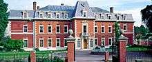
| Polesden Lacey | Great Bookham, Mole Valley | Country House | 1821-1824 | 7 September 1951 | TQ1359152195 51°15′27″N 0°22′25″W |
1028665 | 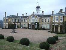 Polesden Lacey |
| Rowhurst | Leatherhead, Mole Valley | House | 17th century | 7 September 1951 | TQ1582158602 51°18′53″N 0°20′22″W |
1293589 | |
| The Running Horse Public House | Leatherhead, Mole Valley | House | Early 19th century | 7 September 1951 | TQ1639156352 51°17′40″N 0°19′56″W |
1293800 | 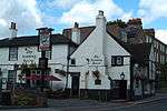 The Running Horse Public House |
| Thorncroft Manor | Leatherhead, Mole Valley | Manor House | Rear extension | 7 September 1951 | TQ1654155864 51°17′24″N 0°19′48″W |
1389370 | |
| 20 - 22 High Street | Dorking, Mole Valley | House | 16th century | 28 November 1951 | TQ1653049334 51°13′53″N 0°19′57″W |
1028899 |  20 - 22 High Street |
.jpg)
.JPG)

_(2).JPG)
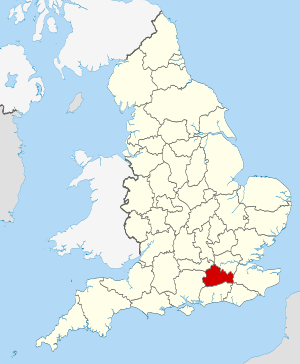
Surrey shown within England
Notes
- The date given is the date used by Historic England as significant for the initial building or that of an important part in the structure's description.
- Sometimes known as OSGB36, the grid reference is based on the British national grid reference system used by the Ordnance Survey.
- The "List Entry Number" is a unique number assigned to each listed building and scheduled monument by Historic England.
References
External links
![]()
This article is issued from Wikipedia. The text is licensed under Creative Commons - Attribution - Sharealike. Additional terms may apply for the media files.