Grade II* listed buildings in Folkestone and Hythe
There are a number of Grade II* listed buildings in the district of Folkestone and Hythe in Kent.
In the United Kingdom, the term listed building refers to a building or other structure officially designated as being of special architectural, historical or cultural significance; Grade II* structures are those considered to be "particularly important buildings of more than special interest".[1] Listing was begun by a provision in the Town and Country Planning Act 1947. Listing a building imposes severe restrictions on what the owner might wish to change or modify in the structure or its fittings. In England, the authority for listing under the Planning (Listed Buildings and Conservation Areas) Act 1990[2] rests with English Heritage, a non-departmental public body sponsored by the Department for Culture, Media and Sport, while local authorities have a responsibility to regulate and enforce the planning regulations.
Buildings and monuments
| Name | Location | Type | Completed [note 1] | Date designated | Grid ref.[note 2] Geo-coordinates |
Entry number [note 3] | Image |
|---|---|---|---|---|---|---|---|
| Acrise Place and Acrise Court | Acrise | House | 16th century | 27 August 1952 | TR1932442196 51°08′13″N 1°08′01″E |
1250981 |  |
| Hoad Farm | Acrise | Farmhouse | 1697 dated | 27 August 1952 | TR2113643106 51°08′40″N 1°09′37″E |
1251021 | |
| Church of St Augustine | Snave, Brenzett | Parish Church | 13th century | 9 June 1959 | TR0142229934 51°02′00″N 0°52′17″E |
1061152 | 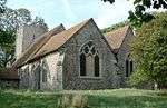 Church of St Augustine |
| Church of St Eanswith | Brenzett | Parish Church | Late 11th century or 12th century | 9 June 1959 | TR0050527730 51°00′50″N 0°51′25″E |
1344185 | |
| Church of All Saints | Burmarsh | Parish Church | 12th century | 9 June 1959 | TR1011832035 51°02′57″N 0°59′47″E |
1061163 | 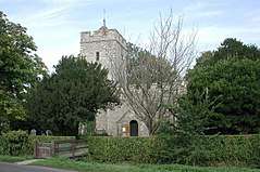 Church of All Saints |
| Church of St Peter and St Paul | Dymchurch | Tower | 1821 | 9 June 1959 | TR1031529737 51°01′43″N 0°59′52″E |
1061130 | 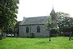 Church of St Peter and St Paul |
| New Hall, New Hall Cottage and the Expenditors House | Dymchurch | House | Addition, probably early 19th century | 9 June 1959 | TR1028829702 51°01′42″N 0°59′51″E |
1061129 | |
| Boyke Manor | Ottinge, Elham | Farmhouse | 17th century | 29 December 1966 | TR1674342410 51°08′24″N 1°05′49″E |
1252276 | 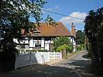 Boyke Manor |
| Elham Manor | Elham | Continuous Jetty House | Early 16th century or earlier | 29 December 1966 | TR1757643935 51°09′12″N 1°06′35″E |
1253867 | .jpg) Elham Manor |
| King Post | Elham | House | 18th century | 29 December 1966 | TR1769943898 51°09′10″N 1°06′42″E |
1260568 | |
| Parsonage Farmhouse | North Elham, Elham | Farmhouse | 13th century or earlier | 29 December 1966 | TR1817844761 51°09′38″N 1°07′08″E |
1252342 | .jpg) Parsonage Farmhouse |
| The Abbots Fireside Hotel and Restaurant | Elham | House | 19th century | 27 August 1952 | TR1763443925 51°09′11″N 1°06′38″E |
1252338 | 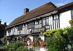 The Abbots Fireside Hotel and Restaurant |
| Dean Farm | Elmsted | Farmhouse | 18th century | 17 October 1988 | TR1246446401 51°10′38″N 1°02′18″E |
1241760 | |
| Old Leigh Place | Elmsted | Farmhouse | 16th century | 29 December 1966 | TR1316547144 51°11′02″N 1°02′56″E |
1241849 | |
| Spong Farm House | Elmsted | Farmhouse | Early-mid 16th century | 29 December 1966 | TR1247245771 51°10′18″N 1°02′17″E |
1260301 | |
| Church of the Holy Trinity | Folkestone, Folkestone | Church | 1866-69 | 11 March 1975 | TR2195035598 51°04′36″N 1°10′02″E |
1344160 | 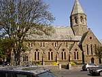 Church of the Holy Trinity |
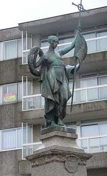
| Folkestone War Memorial | Folkestone | Monument | Unveiled 2 December 1922 | 24 June 2010 | TR2280035755 51°04′40″N 1°10′46″E |
1393854 | |
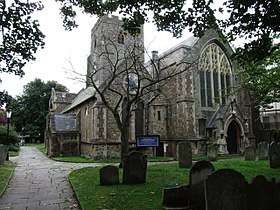
| The Parish Church of St Mary and St Eanswythe | Folkestone, Folkestone | Parish Church | 13th century | 5 December 1949 | TR2295935863 51°04′43″N 1°10′54″E |
1068556 | |
| 18 and 20, Church Street | Folkestone, Folkestone | House | 18th century | 5 December 1949 | TR2293535926 51°04′46″N 1°10′53″E |
1356216 | 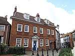 18 and 20, Church Street |
| Centuries 1 and 2, Bartholomew Street |
Hythe | House | 13th century | 3 January 1950 | TR1610934810 51°04′19″N 1°05′00″E |
1069006 | 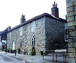 Centuries 1 and 2, Bartholomew Street |
| Town Hall | Hythe | Guildhall | 1794 | 3 January 1950 | TR1618834781 51°04′18″N 1°05′04″E |
1068981 | 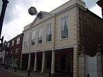 Town Hall |
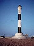
| Dungeness Lighthouse | Dungeness, Lydd | Lighthouse | Designed 1957 | 26 March 2003 | TR0929416883 50°54′48″N 0°58′33″E |
1390640 | |
| Lindon Hall | Lyminge | House | c. 1668, possibly with earlier core | 29 December 1966 | TR1626141233 51°07′46″N 1°05′22″E |
1260204 | 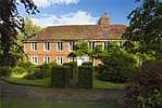 Lindon Hall |
| Sibton Park | Lyminge | House | c. 1602 | 27 August 1952 | TR1587441738 51°08′03″N 1°05′03″E |
1242126 | |
| French House | Lympne, Lympne | House | c. 1930 | 29 December 1966 | TR1123234709 51°04′22″N 1°00′50″E |
1344206 | |
| Port Lympne House, Stable Block, Forecourt Walls to East, and Loggia, Patio, Terrace and Shell Fountain to South | Port Lympne, Lympne | House | 1912 | 29 December 1966 | TR1021934985 51°04′32″N 0°59′58″E |
1344207 | 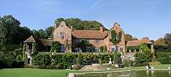 Port Lympne House, Stable Block, Forecourt Walls to East, and Loggia, Patio, Terrace and Shell Fountain to South |
| Church of St Peter | Monks Horton | Parish Church | 13th century | 29 December 1966 | TR1234640536 51°07′29″N 1°01′59″E |
1344171 |  Church of St Peter |
| Kite Manor | Monks Horton | House | mid to late 16th century | 27 August 1952 | TR1156939883 51°07′09″N 1°01′18″E |
1061121 | 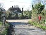 Kite Manor |
| St John's Priory, including the ruins of the Priory | New Romney, New Romney | House | 18th century, possibly older | 28 August 1951 | TR0644124829 50°59′09″N 0°56′24″E |
1025316 | 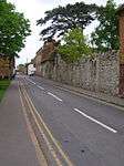 St John's Priory, including the ruins of the Priory |
| 3 and 4, West Street | New Romney, New Romney | House | c. 1400 | 28 August 1951 | TR0625524739 50°59′06″N 0°56′14″E |
1025299 | |
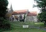
| Church of St Nicholas | Newington, Newington | Bell Tower | late 18th century or early 19th century | 29 December 1966 | TR1826437369 51°05′39″N 1°06′56″E |
1061089 | 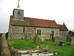 Church of St Nicholas |
| Church of St Peter and St Paul | Saltwood, Saltwood | Tower | 1873 | 29 December 1966 | TR1578936007 51°04′58″N 1°04′46″E |
1344199 | 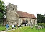 Church of St Peter and St Paul |
| Spade House | Sandgate, Sandgate | House | 1899 | 11 March 1975 | TR2093535326 51°04′29″N 1°09′09″E |
1061164 | |
| Church of St Dunstan | Snargate | Parish Church | 13th century | 9 June 1959 | TQ9906928646 51°01′22″N 0°50′14″E |
1061105 | 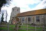 Church of St Dunstan |
| Church of St Mary | Stowting | Parish Church | 13th century | 29 December 1966 | TR1247641845 51°08′11″N 1°02′09″E |
1061070 | 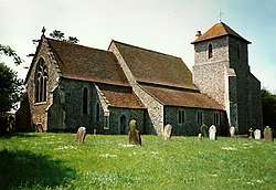 Church of St Mary |
| St John's Commandery | Swingfield | Farmhouse | 16th century | 17 October 1988 | TR2322844015 51°09′07″N 1°11′26″E |
1242361 |  St John's Commandery |
See also
- Grade I listed buildings in Shepway
Notes
- The date given is the date used by Historic England as significant for the initial building or that of an important part in the structure's description.
- Sometimes known as OSGB36, the grid reference is based on the British national grid reference system used by the Ordnance Survey.
- The "List Entry Number" is a unique number assigned to each listed building and scheduled monument by Historic England.
References
- "What is a listed building?". Manchester City Council. Retrieved 2007-12-08.
- "Planning (Listed Buildings and Conservation Areas) Act 1990 (c. 9)". Ministry of Justice. Retrieved 2007-12-17.
External links
![]()