Grade II* listed buildings in East Staffordshire
There are over 20,000 Grade II* listed buildings in England. This page is a list of these buildings in the district of East Staffordshire in Staffordshire.
East Staffordshire
| Name | Location | Type | Completed [note 1] | Date designated | Grid ref.[note 2] Geo-coordinates |
Entry number [note 3] | Image |
|---|---|---|---|---|---|---|---|
| Church House | Abbots Bromley, East Staffordshire | House | Mid C20 | 10 January 1953 | SK0794424630 52°49′09″N 1°53′01″W |
1038414 |  |
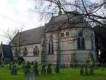
| Church of St Nicholas | Abbots Bromley, East Staffordshire | Parish Church | c. 1300 | 12 January 1966 | SK0793524560 52°49′07″N 1°53′01″W |
1374461 | 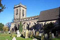 Church of St Nicholas |
| The Butter Cross | Abbots Bromley, East Staffordshire | Village Cross | 17th century | 12 January 1966 | SK0804224576 52°49′07″N 1°52′56″W |
1038424 | 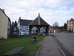 The Butter Cross |
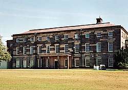
| Barton Hall | Barton-under-Needwood, East Staffordshire | House | Late 18th century | 17 September 1952 | SK1894218847 52°46′01″N 1°43′15″W |
1374405 | .jpg) Barton Hall |
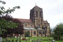
| Church of St James | Barton-under-Needwood, East Staffordshire | Parish Church | 1517 | 12 March 1964 | SK1879218535 52°45′51″N 1°43′23″W |
1038545 | 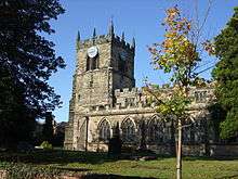 Church of St James |
| 5 Brookside Road | Barton-under-Needwood, East Staffordshire | House | Late Medieval | 10 December 1958 | SK1847218394 52°45′46″N 1°43′40″W |
1374402 | |
| Lower Booth Farmhouse | Blithfield, East Staffordshire | Farmhouse | 15th century | 12 January 1966 | SK0427027159 52°50′31″N 1°56′17″W |
1038401 | |
| Main Gateway to Blithfield Hall with Flanking Walls | Blithfield Park, Blithfield, East Staffordshire | Gate | c. 1820 | 8 August 1985 | SK0453623946 52°48′47″N 1°56′03″W |
1190043 | |
| The Orangery, Blithfield Hall | Blithfield, East Staffordshire | Orangery | c. 1769 | 12 January 1966 | SK0445723992 52°48′48″N 1°56′07″W |
1038399 | |
| Claymills Pumping Station | Burton-on-Trent, East Staffordshire | Sewage Pumping Station | 1886 | 3 January 1986 | SK2629425873 52°49′47″N 1°36′40″W |
1038427 | 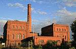 Claymills Pumping Station |
| Gates, Railings and Piers on West Side of Churchyard of Church of St Modwen | Burton-on-Trent, East Staffordshire | Gate | 19th century | 22 June 1979 | SK2505922722 52°48′05″N 1°37′47″W |
1038710 | .jpg) Gates, Railings and Piers on West Side of Churchyard of Church of St Modwen |
| The Abbey (Burton Abbey Club) | Burton-on-Trent, East Staffordshire | Abbey | 1004 | 24 March 1950 | SK2510722601 52°48′01″N 1°37′45″W |
1213613 | |
| 181 Horninglow Street | Burton-on-Trent, East Staffordshire | House | Regency | 24 March 1950 | SK2520323354 52°48′26″N 1°37′39″W |
1038699 | |
| 182, Horninglow Street | Burton-on-Trent, East Staffordshire | House | Early 19th century | 22 June 1979 | SK2521523353 52°48′26″N 1°37′39″W |
1374342 | |
| All Saints Vicarage | Denstone, East Staffordshire | Vicarage | 1860-2 | 30 May 1985 | SK0999940944 52°57′57″N 1°51′09″W |
1278479 | |
| Church of All Saints | Denstone, East Staffordshire | Church | 1949 | 30 May 1985 | SK1003740901 52°57′55″N 1°51′07″W |
1230657 | |
| Lodge about 20m north of Triumphal Arch at Quixhill | Denstone, East Staffordshire | Lodge | Early 19th century | 12 January 1966 | SK1006441303 52°58′08″N 1°51′06″W |
1230718 | .jpg) Lodge about 20m north of Triumphal Arch at Quixhill |
| Lodge about 20m south of Triumphal Arch at Quixhill | Denstone, East Staffordshire | Lodge | Early 19th century | 12 January 1966 | SK1005641266 52°58′07″N 1°51′06″W |
1230589 | Lodge about 20m south of Triumphal Arch at Quixhill |
| Triumphal Arch, Gates and Flanking Railings at Quixhill | Denstone, East Staffordshire | Gate | Early 19th century | 12 January 1966 | SK1005241286 52°58′08″N 1°51′06″W |
1230588 | Triumphal Arch, Gates and Flanking Railings at Quixhill |
| Church of St Mary | Dunstall, East Staffordshire | Parish Church | 1852-3 | 26 March 1986 | SK1874020430 52°46′52″N 1°43′25″W |
1038486 | .jpg) Church of St Mary |
| Dunstall Hall and attached Orangery | Dunstall, East Staffordshire | Country House | Early 19th century | 17 September 1952 | SK1906020452 52°46′53″N 1°43′08″W |
1038487 | |
| Calwich Abbey Temple Flanking Bridges with Gates, Gate Piers and Railings | Calwich Park, Ellastone, East Staffordshire | Gate | 1797 | 10 January 1953 | SK1317743174 52°59′09″N 1°48′19″W |
1230741 | |
| Church of St Peter | Ellastone, East Staffordshire | Church | 1586 | 12 January 1966 | SK1168043450 52°59′18″N 1°49′39″W |
1278444 | .jpg) Church of St Peter |
| Ellastone Old House | Upper Ellastone, Ellstone, East Staffordshire | House | Early to mid 18th century | 10 January 1953 | SK1173643273 52°59′12″N 1°49′36″W |
1230749 | 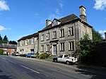 Ellastone Old House |
| Church of St Werburgh | Hanbury, East Staffordshire | Cross | Saxon | 12 March 1964 | SK1708427921 52°50′55″N 1°44′52″W |
1374435 | 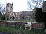 Church of St Werburgh |
| Pair of Gate Piers and Seats in Terrace Garden South of Hoar Cross Hall | Hoar Cross, East Staffordshire | Gate Pier | c. 1600 | 1 November 1989 | SK1234723047 52°48′17″N 1°49′06″W |
1374449 | 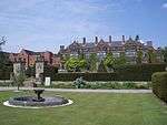 Pair of Gate Piers and Seats in Terrace Garden South of Hoar Cross Hall |
| Pair of Gatepiers and Gates to South Boundary of Terrace Garden at Hoar Cross Hall | Hoar Cross, East Staffordshire | Gate | c. 1700 | 1 November 1989 | SK1234623007 52°48′16″N 1°49′06″W |
1038479 | |
| Callowhill Hall | Kingstone, East Staffordshire | House | Late 17th century | 10 January 1953 | SK0497426388 52°50′06″N 1°55′39″W |
1374476 |  Callowhill Hall |
| Church of All Saints | Church Leigh, Leigh, East Staffordshire | Parish Church | Medieval | 12 January 1966 | SK0239035836 52°55′12″N 1°57′57″W |
1190204 | .jpg) Church of All Saints |
| Church View | Church Leigh, Leigh, East Staffordshire | House | C20 | 8 August 1985 | SK0251935726 52°55′08″N 1°57′50″W |
1038374 | |
| Church of St Peter | Marchington, East Staffordshire | Parish Church | 1742 | 12 January 1966 | SK1379530728 52°52′26″N 1°47′47″W |
1190260 | .jpg) Church of St Peter |
| Marchington Hall | Marchington, East Staffordshire | House | c. 1690 | 10 January 1953 | SK1346931011 52°52′35″N 1°48′05″W |
1374504 | |
| Woodroffe's Cottage | Marchington, East Staffordshire | Jettied House | Early 17th century | 10 January 1953 | SK1120629894 52°51′59″N 1°50′06″W |
1038342 | |
| Old Hall Farmhouse | Picadilly, Mayfield, East Staffordshire | Farmhouse | 1680 | 30 May 1985 | SK1519346079 53°00′43″N 1°46′30″W |
1230785 | |
| Old Hall Farmhouse, Garden Wall and Gate Piers | Middle Mayfield, Mayfield, East Staffordshire | Farmhouse | 17th century | 10 January 1953 | SK1474644864 53°00′03″N 1°46′54″W |
1231004 | 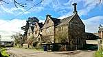 Old Hall Farmhouse, Garden Wall and Gate Piers |
| Church of All Saints | Okeover Park, Okeover, East Staffordshire | Church | 19th century | 12 January 1966 | SK1585148128 53°01′49″N 1°45′54″W |
1231030 | 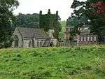 Church of All Saints |
| Gates and Railings enclosing South Side of Garden to West of Okeover Hall | Okeover Park, Okeover, East Staffordshire | Gate | c. 1740 | 10 January 1953 | SK1568648102 53°01′48″N 1°46′03″W |
1231108 | |
| Gates, Gate Piers, Steps and Walls to Kitchen Garden approx. 50 Yards North of Okeover Hall | Okeover Park, Okeover, East Staffordshire | Gate | Mid 18th century | 30 May 1985 | SK1579248247 53°01′53″N 1°45′58″W |
1278304 | |
| Gates, Piers and Railings immediately North East of Okeover Hall | Okeover Park, Okeover, East Staffordshire | Gate | c. 1738 | 30 May 1985 | SK1583048140 53°01′49″N 1°45′55″W |
1231116 | |
| Inner Gate Piers, Gates and Railings to Okeover Hall | Okeover Park, Okeover, East Staffordshire | Gate | 1756-9 | 30 May 1985 | SK1586848161 53°01′50″N 1°45′53″W |
1231033 | |
| Okeover Hall | Okeover Park, Okeover, East Staffordshire | Country House | 1745-9 | 10 January 1953 | SK1580048118 53°01′48″N 1°45′57″W |
1231031 | |
| Outer Gates and Gate Piers to Okeover Hall | Okeover Park, Okeover, East Staffordshire | Gate | c. 1740 | 30 May 1985 | SK1612048153 53°01′50″N 1°45′40″W |
1277410 | .jpg) Outer Gates and Gate Piers to Okeover Hall |
| Statue, Sundial and Steps approx. 30 Yards North of Okeover Hall | Okeover Park, Okeover, East Staffordshire | Steps | 1741 | 30 May 1985 | SK1583648166 53°01′50″N 1°45′55″W |
1278305 | |
| Temple of Pomona, Okeover Hall | Okeover Park, Okeover, East Staffordshire | Pavilion | c1737-48 | 30 May 1985 | SK1583148296 53°01′54″N 1°45′55″W |
1231036 | |
| Gate Piers and Courtyard Walls to East of Wootton Lodge | Wootton Park, Ramshorn, East Staffordshire | Gate | 17th century | 10 January 1953 | SK0964043792 52°59′29″N 1°51′28″W |
1231038 | |
| Pair of Pavilions to North East and South East Corners of Courtyard East of Wootton Lodge | Wootton Park, Ramshorn, East Staffordshire | Pavilion | 17th century | 10 January 1953 | SK0963243774 52°59′28″N 1°51′29″W |
1278309 | |
| Banks Farmhouse | Rocester, East Staffordshire | Farmhouse | Early 18th century | 12 January 1966 | SK0990838959 52°56′53″N 1°51′14″W |
1231926 | |
| Cross approximately 40 Yards North of Church of St Michael | Rocester, East Staffordshire | Cross | 13th century | 12 January 1966 | SK1117039394 52°57′07″N 1°50′07″W |
1231920 | .jpg) Cross approximately 40 Yards North of Church of St Michael |
| Church of St Paul | Shobnall, East Staffordshire | Parish Church | 1874 | 24 March 1950 | SK2390523462 52°48′29″N 1°38′49″W |
1288714 | |
| Sinai Park | Shobnall, East Staffordshire | Farmhouse | Mid 17th century | 17 September 1952 | SK2222123097 52°48′18″N 1°40′19″W |
1038484 | |
| Church of St Mary | Stretton, East Staffordshire | Parish Church | 1895-7 | 12 March 1963 | SK2537426354 52°50′03″N 1°37′29″W |
1293648 | |
| Church of All Saints | Tatenhill, East Staffordshire | Chapel of Ease | 1866-7 | 26 March 1986 | SK1805522965 52°48′14″N 1°44′01″W |
1038436 | .jpg) Church of All Saints |
| Church of St Michael | Tatenhill, East Staffordshire | Parish Church | 13th century | 12 March 1964 | SK2054422076 52°47′45″N 1°41′48″W |
1038433 | 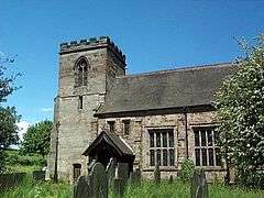 Church of St Michael |
| The Old Rectory | Tatenhill, East Staffordshire | House | 1999 | 17 September 1952 | SK2055222101 52°47′46″N 1°41′48″W |
1038432 | |
| Dog and Partridge Hotel | Tutbury, East Staffordshire | Coaching Inn | Late C15-Early 16th century | 17 September 1952 | SK2126628898 52°51′26″N 1°41′08″W |
1188498 | 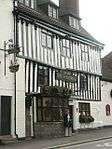 Dog and Partridge Hotel |
| Bank House | Uttoxeter, East Staffordshire | House | Late 18th century | 24 October 1950 | SK0932033524 52°53′57″N 1°51′46″W |
1374326 | |
| Dove Bridge | Uttoxeter, East Staffordshire | Road Bridge | 15th century | 13 September 1967 | SK1055634465 52°54′27″N 1°50′40″W |
1237731 | 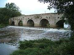 Dove Bridge |
| Parish Church of St Mary | Uttoxeter, East Staffordshire | Parish Church | 14th century | 24 October 1950 | SK0932833485 52°53′55″N 1°51′46″W |
1038783 | 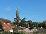 Parish Church of St Mary |
| The Manor House | Uttoxeter, East Staffordshire | House | Pre 1500 | 24 October 1950 | SK0907033749 52°54′04″N 1°52′00″W |
1293560 | |
| 25 Market Place | Uttoxeter, East Staffordshire | Timber Framed House | Medieval | 8 January 1983 | SK0923933372 52°53′52″N 1°51′51″W |
1372432 | |
| Loxley Hall | Loxley Park, Uttoxeter Rural, East Staffordshire | House | Earlier than early 19th century | 10 January 1953 | SK0613232123 52°53′12″N 1°54′37″W |
1190360 | |
| Church of St Leonard | Wychnor, East Staffordshire | Parish Church | 12th century | 12 March 1964 | SK1768816074 52°44′31″N 1°44′22″W |
1038440 | 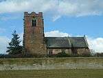 Church of St Leonard |
| Church of St Peter | Yoxall, East Staffordshire | Parish Church | 13th century | 12 March 1964 | SK1417019042 52°46′08″N 1°47′29″W |
1374422 | 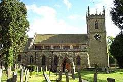 Church of St Peter |
| Pear Tree Farmhouse | Yoxall, East Staffordshire | Farmhouse | Circa 14th century | 28 October 1998 | SK1423719305 52°46′16″N 1°47′26″W |
1038475 | |
| Burton upon Trent War Memorial | Burton upon Trent | War memorial | 1922 | 22 June 1979 | SK2497322594 52°48′01″N 1°37′52″W |
1288788 | .jpg) Burton upon Trent War Memorial |
.jpg)
.jpg)
Notes
- The date given is the date used by Historic England as significant for the initial building or that of an important part in the structure's description.
- Sometimes known as OSGB36, the grid reference is based on the British national grid reference system used by the Ordnance Survey.
- The "List Entry Number" is a unique number assigned to each listed building and scheduled monument by Historic England.
External links
![]()
This article is issued from Wikipedia. The text is licensed under Creative Commons - Attribution - Sharealike. Additional terms may apply for the media files.