Grabfeld, Thuringia
Grabfeld is a municipality in the district Schmalkalden-Meiningen, in Thuringia, Germany.
Grabfeld | |
|---|---|
 Coat of arms | |
Location of Grabfeld within Schmalkalden-Meiningen district 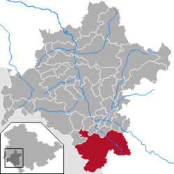 | |
 Grabfeld  Grabfeld | |
| Coordinates: 50°27′N 10°26′E | |
| Country | Germany |
| State | Thuringia |
| District | Schmalkalden-Meiningen |
| Subdivisions | 13 |
| Area | |
| • Total | 121.08 km2 (46.75 sq mi) |
| Elevation | 360 m (1,180 ft) |
| Population (2018-12-31)[1] | |
| • Total | 5,653 |
| • Density | 47/km2 (120/sq mi) |
| Time zone | CET/CEST (UTC+1/+2) |
| Postal codes | 98631 |
| Dialling codes | 036944, 036947 |
| Vehicle registration | SM |
| Website | www |
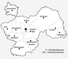
Villages within Grabfeld
Grabfeld was established as a municipality on December 1, 2007 by combining the former municipalities of Behrungen, Berkach, Bibra, Exdorf, Jüchsen, Nordheim, Queienfeld, Rentwertshausen, Schwickershausen and Wolfmannshausen, replacing the former Verwaltungsgemeinschaft of the same name. It was joined by the former municipality Bauerbach in January 2012, and by Wölfershausen in January 2019.
History
Within the German Empire (1871–1918), the territory of the present-day municipality of Grabfeld was part of the Duchy of Saxe-Meiningen.
References
- "Bevölkerung der Gemeinden, erfüllenden Gemeinden und Verwaltungsgemeinschaften nach Geschlecht in Thüringen Gebietsstand: 31.12.2018". Thüringer Landesamt für Statistik (in German). September 2019.
| Authority control |
|
|---|
This article is issued from Wikipedia. The text is licensed under Creative Commons - Attribution - Sharealike. Additional terms may apply for the media files.