Gosaikunda Rural Municipality
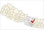
Gosaikunda is a rural municipality located in Rasuwa District of Bagmati Pradesh in Nepal.[1] Rasuwa district is divided into five rural municipality and Gosaikunda is one of them. It is located near the border of Tibet-China on Himalayan range. It is surrounded by Sindhupalchok District in east, Naukunda gaunpalika and Kalika gaunpalika in south and Uttargaya gaunpalika and Parbatikunda gaunpalika in west. Tibet is located on the north side of the rural municipality. Total area of the rural municipality is 987.77 square kilometres (381.38 sq mi) and total population is 7,143 individuals. [2] [3] [4]
Gosaikunda गोसाईंकुण्ड गाउँपालिका | |
|---|---|
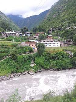 A scene of village in Syaphru | |
 Gosaikunda Location of Gosaikunda | |
| Coordinates: 28°9′48.68″N 85°20′10.77″E | |
| Country | |
| Province | Bagmati Pradesh |
| District | Rasuwa |
| Wards | 5 |
| Established | 10 March 2017 |
| Government | |
| • Type | Rural Council |
| • Chairperson | Mr. Kaisang Nurpu Tamang |
| • Vice-chairperson | Mrs. Kar Gyalmu Shreshtha |
| Area | |
| • Total | 987.77 km2 (381.38 sq mi) |
| Population (2011) | |
| • Total | 7,143 |
| • Density | 7.2/km2 (19/sq mi) |
| Time zone | UTC+5:45 (Nepal Standard Time) |
| Postal Code | 45000 |
| Area code(s) | 010 |
| Headquarter | Syaphru |
| Website | Official Website |
The rural municipality was formed on 10 March 2017, when Government of Nepal announced 753 local level units as per the new constitution of Nepal 2015[5] thus the rural municipality came into existence. The municipality was formed merging following former VDCs: Thuman, Timure, Briddhim Langtang, Syaphru and Dhunche. The municipality is divided into 5 wards and the admin center of the rural municipality is located at Syaphru (ward no. 5).[4]
Etymology
Gosaikunda rural municipality was named after Gosaikunda lake, which is situated in Langtang National Park. The area of the park is extended into 3 dristricts Nuwakot, Rasuwa and Sindhupalchok but the Gsaikunda lake falls under Rasuwa District.
Point of interest
References
- "Gosaikunda (Rural Municipality, Nepal) - Population Statistics, Charts, Map and Location". www.citypopulation.de. Retrieved 30 March 2020.
- "District Corrected Last for RAJAPATRA" (PDF). www.mofald.gov.np. Retrieved 17 July 2018.
- "स्थानीय तहहरुको विवरण" [Details of the local level bodies]. www.mofald.gov.np/en (in Nepali). Ministry of Federal Affairs and Local Development. Archived from the original on 31 August 2018. Retrieved 17 July 2018.
- "Official website of Gosaikund rural municipality". www.gosaikundamun.gov.np. Retrieved 7 May 2019.
- "New local level structure comes into effect from today". www.thehimalayantimes.com. The Himalayan Times. 10 March 2017. Retrieved 17 July 2018.
Headquarters: Dhunche | ||
| Rural municipalities |
|  |
| Former VDCs | ||