Langtang National Park
Langtang National Park was established in 1976 as Nepal's first Himalayan national park and the country's fourth protected area. It exceeds an elevation range of 6,450 m (21,160 ft) and covers an area of 1,710 km2 (660 sq mi) in the Nuwakot, Rasuwa and Sindhulpalchok Districts of the central Himalayan region encompassing 26 village communities. In the north and east it is linked with Qomolangma National Nature Preserve in Tibet Autonomous Region.[1] The western boundary follows the Bhote Koshi and the Trishuli river. The southern border lies 32 km (20 mi) north of the Kathmandu Valley.[2]
| Langtang National Park | |
|---|---|
| Nepali: लामटा.्ग | |
IUCN category II (national park) | |
 Langtang National Park | |
 | |
| Location | Nepal |
| Nearest city | Kathmandu |
| Coordinates | 28°10′26″N 85°33′11″E |
| Area | 1,710 km2 (660 sq mi) |
| Established | 1976 |
| Governing body | Department of National Parks and Wildlife Conservation |
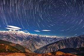
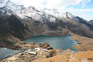
The Gosainkunda lake is located at an elevation of 4,300 m (14,100 ft) inside the park. The Dorje Lakpa range at 6,988 m (22,927 ft) bisects the park from west–east to south–east. The summit of Langtang Lirung (7,245 m (23,770 ft)) is the highest point in the park.[3]
Langtang National Park is part of the Sacred Himalayan Landscape.[4]
History
In 1970, royal approval designated the establishment of Langtang National Park as the first protected area in the Himalayas. The national park was gazetted in 1976 and extended by a buffer zone of 420 km2 (160 sq mi) in 1998.[1] Under the Buffer Zone Management Guidelines the conservation of forests, wildlife and cultural resources received top priority, followed by conservation of other natural resources and development of alternative energy.[5]
On 31 July 1992, Thai Airways International Flight 311 crashed into the park. The Airbus A310 was on approach to Tribhuvan International Airport in Kathmandu. All 113 people on board were killed.[6]
Climate

The climate of the park is dominated by the southwest summer monsoon. Temperatures vary greatly due to the extreme difference in altitude in the entire area. Most of the annual precipitation occurs from June to September. From October to November and from April to May, days are warm and sunny, and nights cool. In spring, rain at 3,000 m (9,800 ft) elevation often turns to snow at higher elevations. In winter from December to March, days are clear and mild but nights near freezing.[7]
Flora and Fauna
Langtang National Park exhibits a high diversity of 14 vegetation types in 18 ecosystem types, ranging from upper tropical forests below 1,000 m (3,300 ft) m altitude to alpine scrub and perennial ice.[1]
References
- Bhuju, U. R., Shakya, P. R., Basnet, T. B., Shrestha, S. (2007). Nepal Biodiversity Resource Book. Protected Areas, Ramsar Sites, and World Heritage Sites (PDF). Kathmandu: International Centre for Integrated Mountain Development, Ministry of Environment, Science and Technology, in cooperation with United Nations Environment Programme, Regional Office for Asia and the Pacific. ISBN 978-92-9115-033-5. Archived from the original (PDF) on 2011-07-26. Retrieved 2018-12-14.CS1 maint: uses authors parameter (link)
- Yonzon, P.; Jones, R.; Fox, J. (1991). "Geographic Information Systems for Assessing Habitat and Estimating Population of Red Pandas in Langtang National Park, Nepal". Ambio. 20 (7): 285–288.
- Mishra, P. N. (2003). "The Langtang National Park: a proposed first Biosphere Reserve in Nepal". Journal of the National Science Foundation of Sri Lanka. 31 (1&2): 333–335.
- Gurung, C. P.; Maskey, T. M.; Poudel, N.; Lama, Y.; Wagley, M. P.; Manandhar, A.; Khaling, S.; Thapa, G.; Thapa, S.; Wikramanayake, E. D. (2006). "The Sacred Himalayan Landscape: Conceptualizing, Visioning, and Planning for Conservation of Biodiversity, Culture and Livelihoods in the Eastern Himalaya" (PDF). In McNeely, J. A.; McCarthy, T. M.; Smith, A.; Whittaker, O. L.; Wikramanayake, E. D. (eds.). Conservation Biology in Asia. Kathmandu: Nepal Society for Conservation Biology, Asia Section and Resources Himalaya Foundation. pp. 10–20. ISBN 99946-996-9-5.
- Heinen, J. T. and J. N. Mehta (2000). Emerging Issues in Legal and Procedural Aspects of Buffer Zone Management with Case Studies from Nepal. Journal of Environment and Development 9 (1): 45–67.
- Ranter, Harro. "ASN Aircraft accident Airbus A310-304 HS-TID Kathmandu-Tribhuvan Airport (KTM)". aviation-safety.net. Retrieved 2019-11-10.
- Sayers, K., Norconk, M.A. (2008). Himalayan Semnopithecus entellus at Langtang National Park, Nepal: Diet, Activity Patterns, and Resources. International Journal of Primatology (2008) 29: 509–530.
External links
| Wikivoyage has a travel guide for Langtang National Park. |
| Wikivoyage has a travel guide for Langtang Valley Trek. |
- BirdLife International. "Important Bird Areas factsheet: Langtang National Park".
- "Langtang National Park". Department of National Parks and Wildlife Conservation. Archived from the original on 2018-12-30. Retrieved 2017-08-21.
- EnvironmentNEPAL Langtang National Park
| Authority control |
|
|---|