Golyanovo District
Golyanovo District (Russian: райо́н Голья́ново) is a district of Eastern Administrative Okrug of the federal city of Moscow, Russia. Population: 157,040 (2010 Census);[3] 159,147 (2002 Census).[4]
Golyanovo District | |
|---|---|
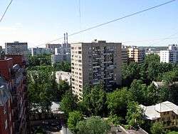 Neighborhood in Golyanovo District | |
.png) Flag .png) Coat of arms | |
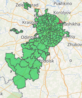
Location of Golyanovo District on the map of Moscow | |
| Coordinates: 55°49′14″N 37°48′26″E | |
| Country | Russia |
| Federal subject | Moscow |
| Area | |
| • Total | 149,902 km2 (57,877 sq mi) |
| Population | |
| • Estimate (2018)[1] | 162,715 |
| Time zone | UTC+3 (MSK |
| OKTMO ID | 45305000 |
| Website | http://golyanovo.mos.ru/ |
It is one of the largest districts in Moscow, both in terms of the geographic area and population size. Located 9-15 km to the east of the Kremlin, this large territory is bounded by MKAD (Moscow Automobile Ring Road), Shchyolkovskoye Shosse, and the national park "Losiny Ostrov".
Golyanovo is named after minnow (golyan in Russian), which was once abundant in the local lakes. The first mention of Golyanovo dates back to the 17th century. Golyanovo was incorporated into the city of Moscow in the early 1960s. At approximately the same time, city officials started massive construction projects in the district, building numerous microdistricts.[5]
References
- "26. Численность постоянного населения Российской Федерации по муниципальным образованиям на 1 января 2018 года". Federal State Statistics Service. Retrieved January 23, 2019.
- "Об исчислении времени". Официальный интернет-портал правовой информации (in Russian). June 3, 2011. Retrieved January 19, 2019.
- Russian Federal State Statistics Service (2011). "Всероссийская перепись населения 2010 года. Том 1" [2010 All-Russian Population Census, vol. 1]. Всероссийская перепись населения 2010 года [2010 All-Russia Population Census] (in Russian). Federal State Statistics Service.
- Russian Federal State Statistics Service (May 21, 2004). "Численность населения России, субъектов Российской Федерации в составе федеральных округов, районов, городских поселений, сельских населённых пунктов – районных центров и сельских населённых пунктов с населением 3 тысячи и более человек" [Population of Russia, Its Federal Districts, Federal Subjects, Districts, Urban Localities, Rural Localities—Administrative Centers, and Rural Localities with Population of Over 3,000] (XLS). Всероссийская перепись населения 2002 года [All-Russia Population Census of 2002] (in Russian).
- "General Information" (in Russian). Golyanovo District. Retrieved March 27, 2018.
| Central Administrative Okrug |  | |
|---|---|---|
| Northern Administrative Okrug | ||
| North-Eastern Administrative Okrug | ||
| Eastern Administrative Okrug | ||
| South-Eastern Administrative Okrug | ||
| Southern Administrative Okrug | ||
| South-Western Administrative Okrug | ||
| Western Administrative Okrug | ||
| North-Western Administrative Okrug | ||
| Zelenogradsky Administrative Okrug | ||
| Novomoskovsky Administrative Okrug |
| |
| Troitsky Administrative Okrug |
| |