Glen Elder, Kansas
Glen Elder is a city in Mitchell County, Kansas, United States. As of the 2010 census, the city population was 445.[6]
Glen Elder, Kansas | |
|---|---|
 Glen Elder Statue of Liberty (2017) | |
 Location within Mitchell County and Kansas | |
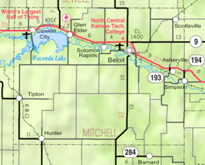 KDOT map of Mitchell County (legend) | |
| Coordinates: 39°29′59″N 98°18′27″W | |
| Country | United States |
| State | Kansas |
| County | Mitchell |
| Founded | 1871 |
| Incorporated | 1879 |
| Area | |
| • Total | 0.44 sq mi (1.14 km2) |
| • Land | 0.44 sq mi (1.14 km2) |
| • Water | 0 sq mi (0 km2) |
| Elevation | 1,434 ft (437 m) |
| Population | |
| • Total | 445 |
| • Estimate (2018)[3] | 433 |
| • Density | 1,000/sq mi (390/km2) |
| Time zone | UTC-6 (CST) |
| • Summer (DST) | UTC-5 (CDT) |
| ZIP code | 67446 |
| Area code | 785 |
| FIPS code | 20-26500 [4] |
| GNIS ID | 0472182 [5] |
| Website | glenelder.com |
History
Glen Elder was originally known as West Hampton, and under the latter name was laid out and platted in 1871 by promoters who built a large gristmill at the site.[7] The town later adopted the name Glen Elder when the post office of that name was moved there from its former location a half mile north.[8] The present name is after a grove of box elder trees.[9] Glen Elder incorporated in 1879.[10]
Geography
Glen Elder is located at 39°29′59″N 98°18′27″W (39.499714, -98.307509).[11] According to the United States Census Bureau, the city has a total area of 0.44 square miles (1.14 km2), all of it land.[1]
Demographics
| Historical population | |||
|---|---|---|---|
| Census | Pop. | %± | |
| 1880 | 165 | — | |
| 1890 | 407 | 146.7% | |
| 1900 | 481 | 18.2% | |
| 1910 | 565 | 17.5% | |
| 1920 | 615 | 8.8% | |
| 1930 | 617 | 0.3% | |
| 1940 | 555 | −10.0% | |
| 1950 | 582 | 4.9% | |
| 1960 | 444 | −23.7% | |
| 1970 | 422 | −5.0% | |
| 1980 | 491 | 16.4% | |
| 1990 | 448 | −8.8% | |
| 2000 | 439 | −2.0% | |
| 2010 | 445 | 1.4% | |
| Est. 2018 | 433 | [3] | −2.7% |
| U.S. Decennial Census | |||
2010 census
As of the census[2] of 2010, there were 445 people, 193 households, and 129 families residing in the city. The population density was 1,011.4 inhabitants per square mile (390.5/km2). There were 250 housing units at an average density of 568.2 per square mile (219.4/km2). The racial makeup of the city was 96.9% White, 0.4% African American, 0.9% Native American, 0.9% Asian, and 0.9% from two or more races. Hispanic or Latino of any race were 2.0% of the population.
There were 193 households of which 30.6% had children under the age of 18 living with them, 56.0% were married couples living together, 5.2% had a female householder with no husband present, 5.7% had a male householder with no wife present, and 33.2% were non-families. 31.6% of all households were made up of individuals and 19.2% had someone living alone who was 65 years of age or older. The average household size was 2.31 and the average family size was 2.84.
The median age in the city was 41.2 years. 27% of residents were under the age of 18; 5.8% were between the ages of 18 and 24; 22% were from 25 to 44; 26.5% were from 45 to 64; and 18.7% were 65 years of age or older. The gender makeup of the city was 50.1% male and 49.9% female.
2000 census
As of the census[4] of 2000, there were 439 people, 196 households, and 130 families residing in the city. The population density was 1,131.1 people per square mile (434.6/km2). There were 265 housing units at an average density of 682.8 per square mile (262.4/km2). The racial makeup of the city was 96.81% White, 0.68% African American, 0.68% Native American, 0.46% Asian, 0.46% from other races, and 0.91% from two or more races. Hispanic or Latino of any race were 1.14% of the population.
There were 196 households out of which 28.1% had children under the age of 18 living with them, 56.1% were married couples living together, 9.2% had a female householder with no husband present, and 33.2% were non-families. 27.6% of all households were made up of individuals and 18.4% had someone living alone who was 65 years of age or older. The average household size was 2.24 and the average family size was 2.75.
In the city, the population was spread out with 22.8% under the age of 18, 8.0% from 18 to 24, 20.5% from 25 to 44, 23.0% from 45 to 64, and 25.7% who were 65 years of age or older. The median age was 44 years. For every 100 females, there were 97.7 males. For every 100 females age 18 and over, there were 93.7 males.
The median income for a household in the city was $26,000, and the median income for a family was $32,361. Males had a median income of $21,528 versus $18,125 for females. The per capita income for the city was $20,169. About 5.4% of families and 9.9% of the population were below the poverty line, including 10.2% of those under age 18 and 10.0% of those age 65 or over.
Parks and Recreation
- Waconda Lake and Glen Elder State Park.
Education
Glen Elder is served by USD 272 Waconda. The district elementary school is Lakeside Elementary School in Cawker City. The district high school is Lakeside High School in Downs with the mascot Knights.[12]
School unification combined Cawker City High School with Glen Elder High School in 1971 forming Waconda East High School. The Waconda East High School mascot was Vikings. Waconda East High School was then unified with Downs High School in 2003 forming USD 272.[13]
Glen Elder High School was closed through school unification. The Glen Elder High School mascot was Glen Elder Bearcats.[14]
The district previously operated Glen Elder Elementary School and Glen Elder Junior High School.[15]
References
- "US Gazetteer files 2010". United States Census Bureau. Archived from the original on January 12, 2012. Retrieved 2012-07-06.
- "U.S. Census website". United States Census Bureau. Retrieved 2012-07-06.
- "Population and Housing Unit Estimates". Retrieved March 21, 2020.
- "U.S. Census website". United States Census Bureau. Retrieved 2008-01-31.
- "US Board on Geographic Names". United States Geological Survey. 2007-10-25. Retrieved 2008-01-31.
- "2010 City Population and Housing Occupancy Status". U.S. Census Bureau. Retrieved October 10, 2011.
- "Histories of Mitchell County Towns". Blue Skyways. Kansas State Library. 1954. Archived from the original on 7 November 2013. Retrieved 15 June 2014.
- Blackmar, Frank Wilson (1912). Kansas: A Cyclopedia of State History, Embracing Events, Institutions, Industries, Counties, Cities, Towns, Prominent Persons, Etc. Standard Publishing Company. pp. 752.
- Heim, Michael (2007). Exploring Kansas Highways. p. 78.
- "Origin of Town Names" (PDF). Solomon Valley Highway 24 Heritage Alliance. p. 2. Retrieved 9 April 2018.
- "US Gazetteer files: 2010, 2000, and 1990". United States Census Bureau. 2011-02-12. Retrieved 2011-04-23.
- "Waconda USD 272". USD 272. Retrieved 7 January 2017.
- "History of Glen Elder" (PDF). Solomon Valley Highway 24 Heritage Foundation. Retrieved 30 December 2016.
- "White Rock Champs", The Salina Journal, White Rock Champs, p.14.
- Home. Waconda USD 272. April 9, 2002. Retrieved on February 25, 2017.
Further reading
External links
- City
- Maps
- Glen Elder City Map, KDOT
Municipalities and communities of Mitchell County, Kansas, United States | ||
|---|---|---|
| Cities | 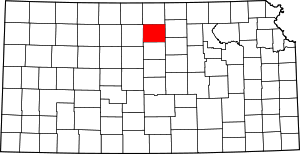 Map of Kansas highlighting Mitchell County | |
| CDP | ||
| Unincorporated community | ||
| Ghost towns | ||
| Townships |
| |
| Footnotes | ‡This populated place also has portions in an adjacent county or counties | |