Downs, Kansas
Downs is a city in Osborne County, Kansas, United States. As of the 2010 census, the city population was 900.[6]
Downs, Kansas | |
|---|---|
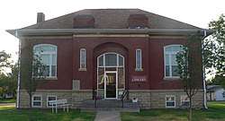 Downs Carnegie Library (2014) | |
 Location within Osborne County and Kansas | |
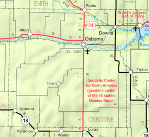 KDOT map of Osborne County (legend) | |
| Coordinates: 39°30′12″N 98°32′37″W | |
| Country | United States |
| State | Kansas |
| County | Osborne |
| Founded | 1879 |
| Incorporated | 1879 |
| Named for | William Downs |
| Area | |
| • Total | 1.00 sq mi (2.59 km2) |
| • Land | 1.00 sq mi (2.59 km2) |
| • Water | 0 sq mi (0 km2) |
| Elevation | 1,483 ft (452 m) |
| Population | |
| • Total | 900 |
| • Estimate (2018)[3] | 822 |
| • Density | 900/sq mi (350/km2) |
| Time zone | UTC-6 (CST) |
| • Summer (DST) | UTC-5 (CDT) |
| ZIP code | 67437 |
| Area code | 785 |
| FIPS code | 20-18500 [4] |
| GNIS ID | 0472295 [5] |
| Website | downsks.net |
History
Downs had its start in the year 1879 when the Central Branch Railroad was extended to that point.[7] It was named for William F. Downs, a railroad official from Atchison.[8][9] Downs became an incorporated town in December of the same year. In 1910, the city had a population of 1,427. Business included 2 newspapers, a public library, flour mills, grain elevators, and an opera house.
Geography
Downs is located at 39°30′12″N 98°32′37″W (39.503305, -98.543500).[10] According to the United States Census Bureau, the city has a total area of 1.00 square mile (2.59 km2), all of it land.[1]
Demographics
| Historical population | |||
|---|---|---|---|
| Census | Pop. | %± | |
| 1880 | 465 | — | |
| 1890 | 938 | 101.7% | |
| 1900 | 938 | 0.0% | |
| 1910 | 1,427 | 52.1% | |
| 1920 | 1,508 | 5.7% | |
| 1930 | 1,383 | −8.3% | |
| 1940 | 1,219 | −11.9% | |
| 1950 | 1,221 | 0.2% | |
| 1960 | 1,206 | −1.2% | |
| 1970 | 1,268 | 5.1% | |
| 1980 | 1,324 | 4.4% | |
| 1990 | 1,119 | −15.5% | |
| 2000 | 1,038 | −7.2% | |
| 2010 | 900 | −13.3% | |
| Est. 2018 | 822 | [3] | −8.7% |
| U.S. Decennial Census | |||
2010 census
As of the census[2] of 2010, there were 900 people, 424 households, and 239 families residing in the city. The population density was 900.0 inhabitants per square mile (347.5/km2). There were 508 housing units at an average density of 508.0 per square mile (196.1/km2). The racial makeup of the city was 97.6% White, 0.1% African American, 1.1% Native American, 0.6% Asian, and 0.7% from two or more races. Hispanic or Latino of any race were 0.9% of the population.
There were 424 households of which 23.3% had children under the age of 18 living with them, 44.6% were married couples living together, 9.4% had a female householder with no husband present, 2.4% had a male householder with no wife present, and 43.6% were non-families. 39.9% of all households were made up of individuals and 18.4% had someone living alone who was 65 years of age or older. The average household size was 2.04 and the average family size was 2.68.
The median age in the city was 49.5 years. 20.2% of residents were under the age of 18; 5.9% were between the ages of 18 and 24; 17.1% were from 25 to 44; 30.8% were from 45 to 64; and 26% were 65 years of age or older. The gender makeup of the city was 47.3% male and 52.7% female.
2000 census
As of the census[4] of 2000, there were 1,038 people, 474 households, and 273 families residing in the city. The population density was 941.4 people per square mile (364.3/km²). There were 543 housing units at an average density of 492.5 per square mile (190.6/km²). The racial makeup of the city was 98.75% White, 0.67% Native American, 0.29% Asian, 0.10% from other races, and 0.19% from two or more races. Hispanic or Latino of any race were 0.48% of the population.
There were 474 households out of which 23.0% had children under the age of 18 living with them, 48.1% were married couples living together, 6.8% had a female householder with no husband present, and 42.4% were non-families. 38.8% of all households were made up of individuals and 20.5% had someone living alone who was 65 years of age or older. The average household size was 2.08 and the average family size was 2.77.
In the city, the population was spread out with 21.5% under the age of 18, 6.7% from 18 to 24, 20.2% from 25 to 44, 22.4% from 45 to 64, and 29.2% who were 65 years of age or older. The median age was 46 years. For every 100 females, there were 91.5 males. For every 100 females age 18 and over, there were 82.3 males.
The median income for a household in the city was $24,808, and the median income for a family was $36,518. Males had a median income of $24,940 versus $16,302 for females. The per capita income for the city was $15,001. About 9.0% of families and 11.1% of the population were below the poverty line, including 5.5% of those under age 18 and 15.2% of those age 65 or over.
Education
Downs is served by USD 272 Waconda. The district elementary school is Lakeside Elementary School in Cawker City. The district high school is Lakeside High School in Downs, with the mascot Knights.[11]
School unification combined Downs and Waconda East schools into USD 272 in 2003. The combined high school became Lakeside Jr./Sr. High School located in Downs.
Downs High School was closed through school unification. The Downs High School mascot was Dragons.[12] The Downs Dragons won the following Kansas State High School championships:
- 1938 Boys Basketball - Class B [13]
- 1950 Boys Basketball - Class B [13]
- 1988 Boys Cross Country - Class 2-1A [14]
Previously the community had Downs Elementary School and Downs Junior High School.[15]
Notable people
- Francis Schmidt, football and basketball coach
See also
- Meades Ranch Triangulation Station, the geodetic base point for the North American Datum of 1927 (NAD 27), which was used as a reference point until 1983.
- Waconda Lake and Glen Elder State Park.
References
- "US Gazetteer files 2010". United States Census Bureau. Archived from the original on 2012-07-02. Retrieved 2012-07-06.
- "U.S. Census website". United States Census Bureau. Retrieved 2012-07-06.
- "Population and Housing Unit Estimates". Retrieved February 23, 2020.
- "U.S. Census website". United States Census Bureau. Retrieved 2008-01-31.
- "US Board on Geographic Names". United States Geological Survey. 2007-10-25. Retrieved 2008-01-31.
- "2010 City Population and Housing Occupancy Status". U.S. Census Bureau. Retrieved September 22, 2011.
- Blackmar, Frank Wilson (1912). Kansas: A Cyclopedia of State History, Embracing Events, Institutions, Industries, Counties, Cities, Towns, Prominent Persons, Etc. Standard Publishing Company. pp. 541.
- Gannett, Henry (1905). The Origin of Certain Place Names in the United States. Govt. Print. Off. pp. 109.
- Heim, Michael (2007). Exploring Kansas Highways. p. 77.
- "US Gazetteer files: 2010, 2000, and 1990". United States Census Bureau. 2011-02-12. Retrieved 2011-04-23.
- "Waconda USD 272". USD 272. Retrieved 7 January 2017.
- "Downs Dragons Hit Hard By Loss Of Veterans", The Salina Journal, 6 September 1951, p.14.
- "KSHSAA Basketball". KSHSAA. Retrieved 3 January 2017.
- "KSHSAA Cross Country". KSHSAA. Retrieved 8 January 2017.
- Home. Waconda USD 272. April 9, 2002. Retrieved on February 25, 2017.
Further reading
External links
| Wikimedia Commons has media related to Downs, Kansas. |
- City
- Schools
- USD 272, local school district
- Pictures
- Historic Images of Downs, Wichita State University Library
- Maps
- Downs City Map, KDOT
Municipalities and communities of Osborne County, Kansas, United States | ||
|---|---|---|
| Cities | 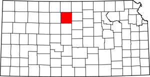 Map of Kansas highlighting Osborne County | |
| Unincorporated communities | ||
| Ghost towns | ||
| Townships |
| |
| Authority control |
|
|---|