Geroldsgrün
Geroldsgrün is a municipality in the Hof district of Bavaria, Germany.
Geroldsgrün | |
|---|---|
 Church of Saint James the Elder | |
 Coat of arms | |
Location of Geroldsgrün within Hof district 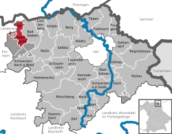 | |
 Geroldsgrün  Geroldsgrün | |
| Coordinates: 50°20′N 11°35′E | |
| Country | Germany |
| State | Bavaria |
| Admin. region | Oberfranken |
| District | Hof |
| Subdivisions | 13 Boroughs |
| Government | |
| • Mayor | Helmut Oelschlegel (SPD) |
| Area | |
| • Total | 15.57 km2 (6.01 sq mi) |
| Elevation | 606 m (1,988 ft) |
| Population (2018-12-31)[1] | |
| • Total | 2,763 |
| • Density | 180/km2 (460/sq mi) |
| Time zone | CET/CEST (UTC+1/+2) |
| Postal codes | 95179 |
| Dialling codes | 09288 and 09267 |
| Vehicle registration | HO |
| Website | www |
Geography
Boroughs
- Dürrenwaid
- Dürrenwaiderhammer
- Langenbachtal
- Langenau
- Langenbach
- Lotharheil
- Mühlleiten
- Geroldsgrün
- Geroldsreuth
- Großenreuth
- Hermesgrün
- Hertwegsgrün
- Hirschberglein
- Silberstein
- Steinbach
- Untersteinbach
The boroughs of Geroldsgrün for the most part are registered air health resorts.
History
The earliest mention of the town is 1323 as Gerhartsgrün. Until recently Geroldsgrün always has been a bordertown between various dominions. In the past it was on the border of the Archdiocese of Bamberg to Grafen von Orlamünde, later between the diocese and Margravate Bayreuth-Kulmbach and in recent times until the reunification between West- and East-Germany.
In 1972 the former municipality of Dürrenwaid becomes part of Geroldsgrün[2] and with the dissolution of the district of Naila Geroldsgrün becomes part of the rural district of Hof. On 1 May 1978 Geroldsgrün reached its current size with the inclusion of Langenbach and Steinbach.[3]
Climate
The annual average temperature in Geroldsgrün is 6.7 °C, the average rainfall is 1,002 mm.
References
- "Fortschreibung des Bevölkerungsstandes". Bayerisches Landesamt für Statistik und Datenverarbeitung (in German). July 2019.
- Wilhelm Volkert (Hrsg.) (1983), Handbuch der bayerischen Ämter, Gemeinden und Gerichte 1799–1980 (in German), München: C.H.Beck’sche Verlagsbuchhandlung, p. 500, ISBN 3-406-09669-7
- Statistisches Bundesamt, ed. (1983), Historisches Gemeindeverzeichnis für die Bundesrepublik Deutschland. Namens-, Grenz- und Schlüsselnummernänderungen bei Gemeinden, Kreisen und Regierungsbezirken vom 27. 5. 1970 bis 31. 12. 1982 (in German), Stuttgart und Mainz: W. Kohlhammer, p. 687, ISBN 3-17-003263-1
Towns and municipalities in Hof (district) | ||
|---|---|---|
| Coat of Arms of Hof district | |
| Authority control |
|
|---|