Galguduud
Galguduud (Somali: Galgaduud, Arabic: جلجدود, Italian: Galgudud or Ghelgudud) is an administrative region (gobol) of Galmudug state in central Somalia.[3] Its administrative capital is Dusmareb.
Galguduud Galgudud, Ghelgudud | |
|---|---|
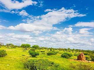 Guriceel District countryside | |
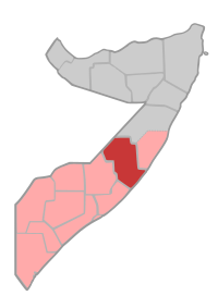 Location in central Somalia | |
| Coordinates: 5°20′13″N 46°37′13″E | |
| Country | |
| Regional State | |
| Capital | Dusmareb |
| Galmudug parliamentary center | Adado |
| Government | |
| • Type | state |
| • Governor | Ahmadnur Ali Jimale |
| Population (2018) | |
| • Total | 800,000[1] |
| Time zone | UTC+3 (EAT) |
| HDI (2017) | 0.270[2] low · 17th |
Galguduud is bordered by Ethiopia, the Somali regions of Mudug; Hiran, Middle Shebelle (Shabeellaha Dhexe), and the Indian Ocean.
The region of Galgaduud and southern half of Mudug formed the Galmudug State by 2016, which considers itself an autonomous state within the larger Federal Republic of Somalia, as defined by the Provisional Constitution of the Federal Republic of Somalia.[4]
Districts
The Galguduud region consists of five Districts:[5]
- Adado District
- Dusmareb District
- Abudwak District
- Balan-Bale District
- El Buur District
- Hobyo District
Major towns
The largest towns within the ten districts of the Galguduud region are:
Small towns
There are smaller towns that reside amongst the major towns, which are:
References
- http://www.fsnau.org/downloads/Somalia%202017%20Post%20Deyr%20Acute%20Food%20Insecurity%20Rural%2C%20Urban%20and%20IDP%20Population%20Stressed%2C%20in%20Crisis%20and%20Emergency%20%28Projection%2C%20February-%20June%202018%29.pdf
- "Sub-national HDI - Area Database - Global Data Lab". hdi.globaldatalab.org. Retrieved 13 September 2018.
- "Somalia". The World Factbook. Langley, Virginia: Central Intelligence Agency. Retrieved 6 December 2013.
- "Somalia's Federal Govt Endorses Central State". All Africa. Retrieved 18 June 2016.
- "Galgaduud Region" (PDF). Retrieved 30 January 2014.
External links
| History |
|  | |||||||
|---|---|---|---|---|---|---|---|---|---|
| Geography |
| ||||||||
| Politics |
| ||||||||
| Economy | |||||||||
| Society |
| ||||||||
| |||||||||