Gaasterlân-Sleat
Gaasterlân-Sleat is a former municipality in the northern Netherlands. Its official name is in West Frisian. The name in Dutch is Gaasterland-Sloten (![]()
Gaasterlân-Sleat Gaasterland-Sloten | |
|---|---|
Former municipality | |
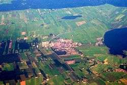 Aerial photo of Balk | |
 Flag  Coat of arms | |
.svg.png) Location in Friesland | |
| Coordinates: 52°54′N 5°35′E | |
| Country | Netherlands |
| Province | Friesland |
| Established | 1 January 1984 |
| Dissolved | 1 January 2014[1] |
| Area | |
| • Total | 209.34 km2 (80.83 sq mi) |
| • Land | 95.24 km2 (36.77 sq mi) |
| • Water | 114.10 km2 (44.05 sq mi) |
| Elevation | 1 m (3 ft) |
| Population (November 2013)[4] | |
| • Total | 10,186 |
| • Density | 107/km2 (280/sq mi) |
| Time zone | UTC+1 (CET) |
| • Summer (DST) | UTC+2 (CEST) |
| Postcode | 8556–8583 |
| Area code | 0514 |
Population centres
Bakhuizen, Balk, Elahuizen, Harich, Kolderwolde, Mirns, Nijemirdum, Oudega, Oudemirdum, Rijs, Ruigahuizen, Sloten, Sondel and Wijckel.
Demographics
In 2010
References
- "Gemeentelijke indeling op 1 januari 2014" [Municipal divisions on 1 January 2014]. cbs.nl (in Dutch). CBS. Retrieved 10 January 2014.
- "Kerncijfers wijken en buurten" [Key figures for neighbourhoods]. CBS Statline (in Dutch). CBS. 2 July 2013. Retrieved 11 July 2013.
- "Postcodetool for 8561BC". Actueel Hoogtebestand Nederland (in Dutch). Het Waterschapshuis. Archived from the original on 21 September 2013. Retrieved 10 September 2013.
- "Bevolkingsontwikkeling; regio per maand" [Population growth; regions per month]. CBS Statline (in Dutch). CBS. 23 December 2013. Retrieved 20 January 2014.
- "Archived copy". Archived from the original on 2016-10-02. Retrieved 2011-05-11.CS1 maint: archived copy as title (link)
External links

Neighbouring municipalities at time of dissolution | ||||||||||
|---|---|---|---|---|---|---|---|---|---|---|
| ||||||||||
Municipalities of Friesland | ||
|---|---|---|
 | ||
| ||
This article is issued from Wikipedia. The text is licensed under Creative Commons - Attribution - Sharealike. Additional terms may apply for the media files.