Fruitvale, Colorado
Fruitvale is a census-designated place (CDP) in Mesa County, Colorado, United States. The population was 7,675 at the 2010 census.[3][4] The Grand Junction Post Office (ZIP Code 81504) serves Fruitvale postal addresses.[2]
Fruitvale, Colorado | |
|---|---|
 The Grand Valley Canal (right, dry in winter) passes through part of Fruitvale | |
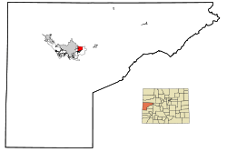 Location in Mesa County and the state of Colorado | |
| Coordinates: 39°5′32″N 108°28′53″W | |
| Country | |
| State | |
| County | Mesa[1] |
| Area | |
| • Total | 3.1 sq mi (8 km2) |
| • Land | 3.1 sq mi (8 km2) |
| • Water | 0 sq mi (0 km2) |
| Elevation | 4,669 ft (1,423 m) |
| Population (2010) | |
| • Total | 7,675 |
| • Density | 2,237.4/sq mi (867/km2) |
| Time zone | UTC-7 (MST) |
| • Summer (DST) | UTC-6 (MDT) |
| ZIP code[2] | 81504 |
| Area code(s) | 970 |
| FIPS code | 08-28800 |
| GNIS feature ID | 0174621 |
Geography
Fruitvale is located at 39°5′32″N 108°28′53″W (39.092349, -108.481512).[5]
According to the United States Census Bureau, the CDP has a total area of 3.1 square miles (8.0 km2), all of it land.
Demographics
| Historical population | |||
|---|---|---|---|
| Census | Pop. | %± | |
| U.S. Decennial Census[6] | |||
As of the census[4] of 2000, there were 6,936 people, 2,656 households, and 2,098 families residing in the CDP. The population density was 2,233.2 people per square mile (861.1/km²). There were 2,747 housing units at an average density of 884.5 per square mile (341.0/km²). The racial makeup of the CDP was 93.41% White, 0.23% African American, 0.72% Native American, 0.62% Asian, 0.01% Pacific Islander, 2.94% from other races, and 2.06% from two or more races. Hispanic or Latino of any race were 6.76% of the population.
There were 2,656 households out of which 33.7% had children under the age of 18 living with them, 69.1% were married couples living together, 6.9% had a female householder with no husband present, and 21.0% were non-families. 18.2% of all households were made up of individuals and 9.3% had someone living alone who was 65 years of age or older. The average household size was 2.61 and the average family size was 2.93.
In the CDP, the population was spread out with 25.7% under the age of 18, 5.7% from 18 to 24, 26.3% from 25 to 44, 24.9% from 45 to 64, and 17.4% who were 65 years of age or older. The median age was 40 years. For every 100 females, there were 96.1 males. For every 100 females age 18 and over, there were 93.3 males.
The median income for a household in the CDP was $44,438, and the median income for a family was $48,920. Males had a median income of $35,500 versus $22,702 for females. The per capita income for the CDP was $19,044. About 2.8% of families and 2.7% of the population were below the poverty line, including 1.2% of those under age 18 and 5.1% of those age 65 or over.
Climate
| Climate data for Fruitvale, Colorado | |||||||||||||
|---|---|---|---|---|---|---|---|---|---|---|---|---|---|
| Month | Jan | Feb | Mar | Apr | May | Jun | Jul | Aug | Sep | Oct | Nov | Dec | Year |
| Average high °F (°C) | 38 (3) |
46 (8) |
56 (13) |
65 (18) |
75 (24) |
86 (30) |
92 (33) |
90 (32) |
81 (27) |
68 (20) |
51 (11) |
41 (5) |
65.75 (18.75) |
| Average low °F (°C) | 17 (−8) |
24 (−4) |
33 (1) |
39 (4) |
48 (9) |
57 (14) |
63 (17) |
61 (16) |
52 (11) |
41 (5) |
29 (−2) |
19 (−7) |
40.25 (4.58) |
| Source: Intellicast[7] | |||||||||||||
References
- U.S. Geological Survey Geographic Names Information System: Fruitvale
- "ZIP Code Lookup". United States Postal Service. December 14, 2006. Archived from the original (JavaScript/HTML) on November 4, 2010. Retrieved December 14, 2006.
- Colorado Trend Report 2: State and Complete Places (Sub-state 2010 Census Data). Missouri Census Data Center. Accessed 2011-02-25.
- "U.S. Census website". United States Census Bureau. Retrieved 2008-01-31.
- "US Gazetteer files: 2010, 2000, and 1990". United States Census Bureau. 2011-02-12. Retrieved 2011-04-23.
- "Census of Population and Housing". Census.gov. Retrieved June 4, 2016.
- "Historic Averages". Retrieved November 7, 2015.
External links
![]()
Municipalities and communities of Mesa County, Colorado, United States | ||
|---|---|---|
| Cities | 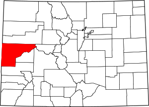 Map of Colorado highlighting Mesa County | |
| Towns | ||
| CDPs | ||
| Unincorporated communities | ||
| Ghost towns | ||