Fresh Pond Road station
Fresh Pond Road is a station on the BMT Myrtle Avenue Line of the New York City Subway located on Fresh Pond Road opposite of 67th Avenue at the border of Ridgewood and Glendale, Queens. The station is served by the M train at all times.
Fresh Pond Road | |||||||
|---|---|---|---|---|---|---|---|
 Platform view | |||||||
| Station statistics | |||||||
| Address | Fresh Pond Road opposite 67th Avenue Queens, NY 11385 | ||||||
| Borough | Queens | ||||||
| Locale | Ridgewood, Glendale | ||||||
| Coordinates | 40.705953°N 73.896704°W | ||||||
| Division | B (BMT) | ||||||
| Line | BMT Myrtle Avenue Line | ||||||
| Services | M | ||||||
| Transit connections | |||||||
| Structure | Elevated | ||||||
| Platforms | 1 island platform | ||||||
| Tracks | 2 | ||||||
| Other information | |||||||
| Opened | August 9, 1915 | ||||||
| Closed | July 1, 2017 (temporary line closure) | ||||||
| Reopened | September 1, 2017 | ||||||
| Station code | 109[1] | ||||||
| Opposite-direction transfer available | Yes | ||||||
| Traffic | |||||||
| Passengers (2019) | 1,776,084[2] | ||||||
| Rank | 263 out of 424[2] | ||||||
| Station succession | |||||||
| Next east | Middle Village: M | ||||||
| Next west | Forest Avenue: M | ||||||
| |||||||
| |||||||
| |||||||


Station layout
| P Platform level |
Westbound | ← |
| Island platform | ||
| Eastbound | | |
| M | Mezzanine | Fare control, station agent, MetroCard machines |
| G | Street level | Exit/entrance |
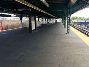
This elevated station, which was opened on August 9, 1915 and originally operated by the Brooklyn Rapid Transit Company, has two tracks and an island platform. The platform is wider than those in most other stations in the system because the station was formerly a major transfer point to the Flushing–Ridgewood streetcar Line to Flushing.[3] This service was replaced by the Q58 bus on July 17, 1949.[4]
A brown canopy with green frames and support columns run along the entire length of the platform except for a small section at the west end (railroad north). Below the station is an MTA-owned lot commonly used for storing buses based out of the neighboring Fresh Pond Bus Depot.
To the east of the station is the Fresh Pond Yard. However, it can only be accessed from Middle Village–Metropolitan Avenue, the next station east (railroad south). Trains heading to the yard from Manhattan and Brooklyn must first enter Metropolitan Avenue, then reverse into the yard.[5]
Exits
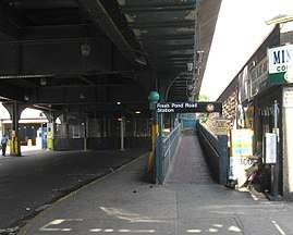
This station has a mezzanine/station house below the platform and tracks near the east (railroad south) end. Two staircases from the platform go down to the waiting area, where a turnstile bank provides access to and from the station. Outside fare control, there is a token booth and two sets of doors.
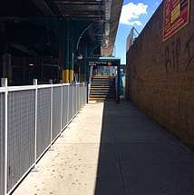
One set of doors leads to an elevated passageway that turns 90 degrees to a short staircase before a stair goes down to the east side of Fresh Pond Road. The passageway has a high exit-only turnstile with its own staircase from the platform.[6] The station house's other set of doors leads to a staircase that goes down to a passageway on the left and also goes to a disused and usually gated staircase on the right. The passageway heads to a four-step stairway at the dead-end of 62nd Street, north of 68th Avenue, and the staircase comes out just east of the start of the stair to Fresh Pond Road.[6] The Fresh Pond Road entrance used to be a ramp to the mezzanine, but the ramp was removed following a 2010s renovation.
References
- "Station Developers' Information". Metropolitan Transportation Authority. Retrieved June 13, 2017.
- "Facts and Figures: Annual Subway Ridership 2014–2019". Metropolitan Transportation Authority. 2020. Retrieved May 26, 2020.
- "New L Train Service to Lutheran Cemetery: B.R.T. Opens a Line To-morrow That Takes Passengers Into Queens County". Brooklyn Daily Eagle. September 30, 1906. p. 33. Retrieved 28 September 2015 – via Newspapers.com.
- "Buses to Replace Crosstown Trolley". Brooklyn Daily Eagle. July 14, 1949. Retrieved 30 September 2015 – via Newspapers.com.
- Dougherty, Peter (2020). Tracks of the New York City Subway 2020 (16th ed.). Dougherty. OCLC 1056711733.
- "MTA Neighborhood Maps: Ridgewood" (PDF). mta.info. Metropolitan Transportation Authority. 2015. Retrieved 20 July 2016.
External links
- nycsubway.org – BMT Myrtle Avenue Line: Fresh Pond Road
- Station Reporter — M Train
- The Subway Nut — Fresh Pond Road Pictures
- Fresh Pond Road entrance from Google Maps Street View
- 62nd Street entrance from Google Maps Street View
- Platform from Google Maps Street View
| Myrtle Ave. Line | |
|---|---|
| |