Framura
Framura (Ligurian: Framua [fɾaˈmyːa]) is a comune (municipality) in the Province of La Spezia in the Italian region Liguria, located about 50 kilometres (31 mi) southeast of Genoa and about 25 kilometres (16 mi) northwest of La Spezia. As of 31 December 2004, it had a population of 739 and an area of 18.9 square kilometres (7.3 sq mi).[3]
Framura | |
|---|---|
| Comune di Framura | |
 Street in the historical centre | |
Location of Framura 
| |
 Framura Location of Framura in Italy 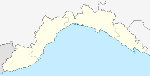 Framura Framura (Liguria) | |
| Coordinates: 44°13′N 9°33′E | |
| Country | Italy |
| Region | Liguria |
| Province | Province of La Spezia (SP) |
| Frazioni | Anzo, Ravecca, Setta, Costa, Castagnola |
| Area | |
| • Total | 18.9 km2 (7.3 sq mi) |
| Population (Dec. 2004)[2] | |
| • Total | 739 |
| • Density | 39/km2 (100/sq mi) |
| Time zone | UTC+1 (CET) |
| • Summer (DST) | UTC+2 (CEST) |
| Postal code | 19014 |
| Dialing code | 0187 |
| Website | http://www.comune.framura.sp.it/ |
The municipality of Framura contains the frazioni (subdivisions, mainly villages and hamlets) Anzo, Ravecca, Setta, Costa, and Castagnola.
Framura borders the following municipalities: Bonassola, Carrodano, Deiva Marina, Levanto.
History
During World War Two, American 15-men missions called Operations Ginny I and II tried to land and blow up a railway tunnel between Framura and Bonassola. Both missions failed but the second mission's soldiers were executed and buried in a mass grave by the German Army.[4]
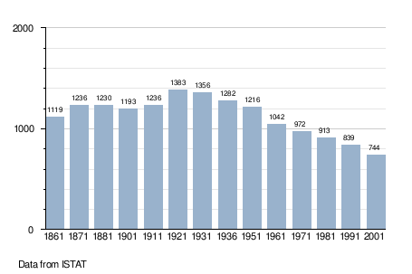
Demographic evolution
References
| Wikivoyage has a travel guide for Framura. |
- "Superficie di Comuni Province e Regioni italiane al 9 ottobre 2011". Istat. Retrieved 16 March 2019.
- "Popolazione Residente al 1° Gennaio 2018". Istat. Retrieved 16 March 2019.
- All demographics and other statistics: Italian statistical institute Istat.
- OSS Operation Ginny met with a tragic end during the Italian Campaign Archived 2009-04-20 at the Wayback Machine, WWII History Magazine, Sept 2005, Don Smart, accessed 2 August 2013